Category:Hochfrottspitze
Vai alla navigazione
Vai alla ricerca
mountain in the Allgäu Alps at the border Tyrol / Bavaria  | |||||
| Carica un file multimediale | |||||
| Istanza di | |||||
|---|---|---|---|---|---|
| Luogo |
| ||||
| Catena montuosa | |||||
| Prominenza topografica |
| ||||
| Isolamento topografico |
| ||||
| Altezza sul mare |
| ||||
 | |||||
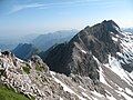
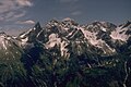
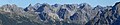
Deutsch: Die Hochfrottspitze ist mit 2649 Meter der dritthöchste Berg der Allgäuer Alpen, über den die Grenze zwischen Deutschland und Österreich verläuft.
English: The Hochfrottspitze (2649 m) is the third highest mountain in the Allgäu Alps (Border between Tyrol/ Austria and Bavaria/ Germany).
File nella categoria "Hochfrottspitze"
Questa categoria contiene 19 file, indicati di seguito, su un totale di 19.
-
 20230278 Alpenpanorama.jpg 4 320 × 2 432; 1,45 MB
-
 Allgäuer Alpen Gebirgskette Oberstdorf 01.jpg 2 172 × 1 633; 1,77 MB
-
 Allgäuer Hauptkamm from Joechelspitze.JPG 3 264 × 2 448; 2,53 MB
-
 Bacherloch Trettachspitze Mädelegabel.jpg 4 000 × 3 000; 4,6 MB
-
 Birgsau 2020c.jpg 4 000 × 3 000; 4,54 MB
-
 Bockkarkopf Hochfrottspitze.JPG 3 264 × 2 448; 3,96 MB
-
 Einödsbachtal - panoramio.jpg 1 024 × 768; 253 KB
-
 Felle Aufzug auf die Alm.jpg 638 × 415; 227 KB
-
 Griesgundkopf Alpgundkopf.JPG 3 264 × 2 448; 3,08 MB
-
 Guggersee Trettachspitze Maedelegabel Hochfrottspitze.JPG 3 264 × 2 448; 3,38 MB
-
 Hochfrottspitze Wilder Kasten from Maedelegabel.JPG 3 264 × 2 448; 4,58 MB
-
 Hochfrottspitze.jpg 2 015 × 1 604; 1,98 MB
-
 Hochfrottspitze02.JPG 3 264 × 2 448; 3,36 MB
-
 Maedelegabelgruppe von Nordwesten.jpg 1 464 × 976; 222 KB
-
 Mädelegabel, Hochfrottspitze, Bockkarkopf ^ Rothgundspitze - panoramio (1).jpg 3 872 × 2 592; 6,52 MB
-
 Mädelegabel, Hochfrottspitze, Bockkarkopf ^ Rothgundspitze - panoramio.jpg 3 872 × 2 437; 638 KB
-
 Oberstdorf - Trettach, Mädelegabel, Hochfrottspitze.JPG 4 000 × 3 000; 1,92 MB
-
 Panorama Schafalpenköpfe from Walmendingerhorn.jpg 18 132 × 3 750; 19,43 MB
-
 Trettach Maedelegabel Hochfrottspitze.JPG 3 264 × 2 448; 3,05 MB


.jpg)


