Category:Hoge der A 8 (Groningen)
Jump to navigation
Jump to search
| Object location | | View all coordinates using: OpenStreetMap |
|---|
building in Groningen, Netherlands  | |||||
| Upload media | |||||
| Instance of | |||||
|---|---|---|---|---|---|
| Location | Groningen, Netherlands | ||||
| Heritage designation |
| ||||
 | |||||
Nederlands: Hoge der A 8, Groningen (15/16de eeuw, rm 18516)
|
This is a category about rijksmonument number 18516
|
| Address |
|
Media in category "Hoge der A 8 (Groningen)"
The following 9 files are in this category, out of 9 total.
-
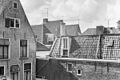 Achterzijde - Groningen - 20093947 - RCE.jpg 1,200 × 800; 246 KB
-
 Gang tussen de twee huizen - Groningen - 20093945 - RCE.jpg 804 × 1,200; 139 KB
-
 Groningen Hoge der A 8.jpg 2,448 × 3,264; 4.59 MB
-
 Groningen Hooge der A 8.jpg 2,042 × 3,558; 2.64 MB
-
 Tussengang, sporen van vensters - Groningen - 20093946 - RCE.jpg 804 × 1,200; 153 KB
-
 Voorgevel - Groningen - 20093954 - RCE.jpg 1,200 × 964; 250 KB
-
 Voorgevels - Groningen - 20093948 - RCE.jpg 816 × 1,200; 225 KB
-
 Voorgevels - Groningen - 20093949 - RCE.jpg 808 × 1,200; 226 KB
-
 Voorgevels - Groningen - 20093950 - RCE.jpg 1,200 × 814; 228 KB


