Category:Hohen Neuendorf, Stolper Straße 23
Jump to navigation
Jump to search
| Object location | | View all coordinates using: OpenStreetMap |
|---|
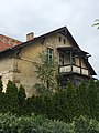
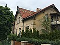
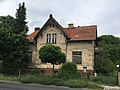
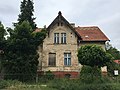
This is the category of the Brandenburger Baudenkmal (cultural heritage monument) with the ID 09166054 (Wikidata)
|
| Upload media | |||||
| Instance of | |||||
|---|---|---|---|---|---|
| Location | Brandenburg, Germany | ||||
| Heritage designation | |||||
 | |||||
Media in category "Hohen Neuendorf, Stolper Straße 23"
The following 10 files are in this category, out of 10 total.
-
 Hohen Neuendorf, Stolper Straße 23 (1).jpg 4,032 × 3,024; 3.14 MB
-
 Hohen Neuendorf, Stolper Straße 23 (10).jpg 4,032 × 3,024; 3.68 MB
-
 Hohen Neuendorf, Stolper Straße 23 (2).jpg 3,024 × 4,032; 2.66 MB
-
 Hohen Neuendorf, Stolper Straße 23 (3).jpg 4,032 × 3,024; 2.36 MB
-
 Hohen Neuendorf, Stolper Straße 23 (4).jpg 4,032 × 3,024; 2.71 MB
-
 Hohen Neuendorf, Stolper Straße 23 (5).jpg 4,032 × 3,024; 3.4 MB
-
 Hohen Neuendorf, Stolper Straße 23 (6).jpg 4,032 × 3,024; 2.8 MB
-
 Hohen Neuendorf, Stolper Straße 23 (7).jpg 4,032 × 3,024; 2.72 MB
-
 Hohen Neuendorf, Stolper Straße 23 (8).jpg 3,024 × 4,032; 4.12 MB
-
 Hohen Neuendorf, Stolper Straße 23 (9).jpg 4,032 × 3,024; 3.23 MB
.jpg)
.jpg)
.jpg)
.jpg)
.jpg)
.jpg)
.jpg)
.jpg)
.jpg)
.jpg)