Category:Horley, Oxfordshire
Jump to navigation
Jump to search
village and civil parish in Cherwell district, Oxfordshire, England  | |||||
| Upload media | |||||
| Instance of | |||||
|---|---|---|---|---|---|
| Location | Cherwell, Oxfordshire, South East England, England | ||||
| Population |
| ||||
| Area |
| ||||
| official website | |||||
 | |||||
English: Horley is a village and civil parish in the north of Oxfordshire about northwest of Banbury.
Subcategories
This category has only the following subcategory.
C
Media in category "Horley, Oxfordshire"
The following 119 files are in this category, out of 119 total.
-
 Alpacas near Horley - geograph.org.uk - 1092729.jpg 640 × 480; 126 KB
-
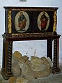 Book cabinet, St Etheldreda's, Horley - geograph.org.uk - 3692304.jpg 1,194 × 1,600; 370 KB
-
 Church Lane, Horley - geograph.org.uk - 3488125.jpg 2,000 × 1,500; 499 KB
-
 Church Lane, Horley - geograph.org.uk - 3488146.jpg 2,000 × 1,391; 577 KB
-
 Church of St Etheldreda, Horley - geograph.org.uk - 3487864.jpg 2,000 × 1,328; 598 KB
-
 Church of St Etheldreda, Horley - geograph.org.uk - 3487906.jpg 2,000 × 1,335; 613 KB
-
 Church of St Etheldreda, Horley - geograph.org.uk - 3487926.jpg 2,000 × 1,500; 614 KB
-
 Church of St Etheldreda, Horley - geograph.org.uk - 3488088.jpg 2,000 × 1,500; 640 KB
-
 Church of St Etheldreda, Horley - geograph.org.uk - 3488103.jpg 2,000 × 1,325; 548 KB
-
 Failed oilseed rape crop - geograph.org.uk - 3489988.jpg 2,000 × 1,500; 592 KB
-
 Farm Track near Glebe farm - geograph.org.uk - 3174860.jpg 640 × 480; 122 KB
-
 Farmland and footpath, Horley - geograph.org.uk - 2676762.jpg 640 × 480; 141 KB
-
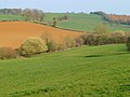 Farmland, Horley - geograph.org.uk - 2676732.jpg 640 × 480; 126 KB
-
 Farmland, Horley - geograph.org.uk - 2676779.jpg 640 × 480; 143 KB
-
 Farmland, Horley - geograph.org.uk - 2676792.jpg 640 × 480; 174 KB
-
 Farmland, Horley - geograph.org.uk - 2676803.jpg 640 × 480; 120 KB
-
 Field margin north east of Quarry Road - geograph.org.uk - 3487805.jpg 2,000 × 1,500; 500 KB
-
 Field near Horley - geograph.org.uk - 1865822.jpg 640 × 480; 88 KB
-
 Fields near Savee Farm - geograph.org.uk - 3486813.jpg 2,000 × 1,500; 573 KB
-
 Footpath between Wroxton and Drayton - geograph.org.uk - 188273.jpg 640 × 480; 150 KB
-
 Footpath descends Bush Hill - geograph.org.uk - 3489839.jpg 1,500 × 2,000; 536 KB
-
 Footpath near Savee Farm - geograph.org.uk - 197983.jpg 640 × 480; 44 KB
-
 Footpath round the trees - geograph.org.uk - 3486737.jpg 2,000 × 1,500; 533 KB
-
 Footpath to Bush Hill - geograph.org.uk - 3494182.jpg 2,000 × 1,500; 574 KB
-
 Footpath to Manor farm - geograph.org.uk - 2694627.jpg 640 × 480; 68 KB
-

-
 Horley duck with sunglasses - geograph.org.uk - 442250.jpg 480 × 640; 109 KB
-
 Horley duck with umbrella - geograph.org.uk - 435069.jpg 480 × 640; 141 KB
-
 Horley tool shed or p-hut 1.png 1,739 × 583; 1.97 MB
-
 Horley tool shed or p-hut 2.JPG 3,620 × 1,228; 767 KB
-
 Horley-Converted Chapel - geograph.org.uk - 4965983.jpg 1,600 × 1,240; 501 KB
-
 Horley2001.jpg 864 × 580; 724 KB
-
 Horse riders in Horley - geograph.org.uk - 3691394.jpg 1,600 × 1,056; 301 KB
-
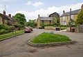
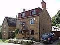
 Houses in Horley - geograph.org.uk - 3174865.jpg 640 × 477; 65 KB
-
 Houses in Horley - geograph.org.uk - 3174870.jpg 640 × 480; 76 KB
-
 Inside St. Etheldreda, Horley (i) - geograph.org.uk - 5099990.jpg 640 × 480; 61 KB
-
 Inside St. Etheldreda, Horley (ii) - geograph.org.uk - 5099995.jpg 480 × 640; 56 KB
-
 Inside St. Etheldreda, Horley (iii) - geograph.org.uk - 5099996.jpg 480 × 640; 78 KB
-
 Inside St. Etheldreda, Horley (iv) - geograph.org.uk - 5099997.jpg 480 × 640; 69 KB
-
 Inside St. Etheldreda, Horley (ix) - geograph.org.uk - 5100002.jpg 640 × 480; 35 KB
-
 Inside St. Etheldreda, Horley (v) - geograph.org.uk - 5099998.jpg 480 × 640; 54 KB
-
 Inside St. Etheldreda, Horley (vi) - geograph.org.uk - 5099999.jpg 480 × 640; 75 KB
-
 Inside St. Etheldreda, Horley (vii) - geograph.org.uk - 5100000.jpg 640 × 480; 75 KB
-
 Inside St. Etheldreda, Horley (viii) - geograph.org.uk - 5100001.jpg 640 × 480; 79 KB
-
 Inside St. Etheldreda, Horley (x) - geograph.org.uk - 5100003.jpg 480 × 640; 65 KB
-
 Inside St. Etheldreda, Horley (xi) - geograph.org.uk - 5100005.jpg 640 × 480; 81 KB
-
 Inside St. Etheldreda, Horley (xii) - geograph.org.uk - 5100006.jpg 480 × 640; 65 KB
-
 Inside St. Etheldreda, Horley (xiii) - geograph.org.uk - 5100007.jpg 480 × 640; 55 KB
-
 Inside St. Etheldreda, Horley (xiv) - geograph.org.uk - 5100008.jpg 480 × 640; 56 KB
-
 Inside St. Etheldreda, Horley (xv) - geograph.org.uk - 5100013.jpg 640 × 480; 66 KB
-
 Inside St. Etheldreda, Horley (xvi) - geograph.org.uk - 5100014.jpg 640 × 480; 55 KB
-

-
 Little Lane, Horley - geograph.org.uk - 1138843.jpg 640 × 480; 120 KB
-
 Little Lane, Horley, Oxon - geograph.org.uk - 1138851.jpg 480 × 640; 120 KB
-
-
 Medieval glass, St Etheldreda's, Horley - geograph.org.uk - 3692278.jpg 1,600 × 1,211; 275 KB
-
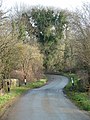
 Minor road, Horley, Oxfordshire - geograph.org.uk - 3691411.jpg 1,600 × 1,045; 503 KB
-
 Organ, St Etheldreda's, Horley - geograph.org.uk - 3692356.jpg 1,600 × 1,194; 381 KB
-
 Pasture Fields at Eastgate Farm - geograph.org.uk - 3174837.jpg 640 × 471; 68 KB
-
 Pulpit, St. Eltheldreda's, Horley - geograph.org.uk - 3692282.jpg 1,600 × 1,422; 409 KB
-
 Red Lion, Horley, late August 2016 - geograph.org.uk - 5099970.jpg 640 × 480; 79 KB
-
 Reservoir by the footpath - geograph.org.uk - 3487794.jpg 2,000 × 1,500; 501 KB
-
 Reservoir by the footpath - geograph.org.uk - 3494218.jpg 2,000 × 1,500; 548 KB
-
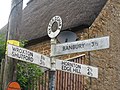
 Road to Horley - geograph.org.uk - 1865810.jpg 640 × 480; 44 KB
-
 Road to Horley - geograph.org.uk - 2698587.jpg 640 × 480; 98 KB
-
 Rood loft,St Etheldreda, Horley - geograph.org.uk - 3692270.jpg 1,600 × 1,200; 364 KB
-
 Rush hour in Horley - geograph.org.uk - 5099972.jpg 480 × 640; 61 KB
-
 Seven Shires Way - geograph.org.uk - 2695065.jpg 640 × 480; 106 KB
-
 Seven Shires Way - geograph.org.uk - 2695073.jpg 640 × 480; 83 KB
-
 Site of Moore Mill - geograph.org.uk - 1138827.jpg 480 × 640; 130 KB
-
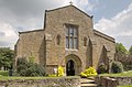
 St Etheldreda's Church, Horley - geograph.org.uk - 2588853.jpg 3,264 × 2,448; 3.21 MB
-
 St Etheldreda's, Horley - geograph.org.uk - 3692337.jpg 1,600 × 1,188; 338 KB
-
 St Etheldreda's, Horley - geograph.org.uk - 3692369.jpg 1,600 × 1,191; 368 KB
-
 St Etheldreda's, Horley, Oxfordshire - geograph.org.uk - 3692264.jpg 1,600 × 988; 348 KB
-
 St. Eltheldreda, Horley, organ - geograph.org.uk - 5100060.jpg 480 × 640; 66 KB
-

-

-

-

-

-
 St. Etheldreda, Horley, churchyard (F) - geograph.org.uk - 5099982.jpg 640 × 480; 126 KB
-
 St. Etheldreda, Horley, churchyard (G) - geograph.org.uk - 5099983.jpg 640 × 480; 103 KB
-
 St. Etheldreda, Horley, churchyard (H) - geograph.org.uk - 5099984.jpg 640 × 480; 103 KB
-

-
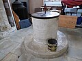 St. Etheldreda, Horley, font - geograph.org.uk - 5099988.jpg 640 × 480; 69 KB
-
 St. Etheldreda, Horley, funeral cart - geograph.org.uk - 5100096.jpg 640 × 480; 81 KB
-

-

-
 St. Etheldreda, Horley, lectern - geograph.org.uk - 5100029.jpg 480 × 640; 65 KB
-
 St. Etheldreda, Horley, main altar - geograph.org.uk - 5100079.jpg 480 × 640; 62 KB
-
 St. Etheldreda, Horley, memorial (a) - geograph.org.uk - 5099991.jpg 640 × 480; 42 KB
-
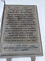 St. Etheldreda, Horley, memorial (b) - geograph.org.uk - 5099992.jpg 480 × 640; 70 KB
-
 St. Etheldreda, Horley, memorial (c) - geograph.org.uk - 5099993.jpg 640 × 480; 68 KB
-
 St. Etheldreda, Horley, memorial (d) - geograph.org.uk - 5099994.jpg 640 × 480; 56 KB
-
 St. Etheldreda, Horley, memorial (e) - geograph.org.uk - 5100009.jpg 640 × 480; 70 KB
-
 St. Etheldreda, Horley, memorial (i) - geograph.org.uk - 5099987.jpg 640 × 480; 67 KB
-
 St. Etheldreda, Horley, pulpit - geograph.org.uk - 5100137.jpg 480 × 640; 71 KB
-
 St. Etheldreda, Horley, side altar - geograph.org.uk - 5100111.jpg 640 × 480; 65 KB
-
 St. Etheldreda, Horley, south door - geograph.org.uk - 5099986.jpg 480 × 640; 87 KB
-
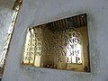
 St. Etheldreda, Horley, The Creed - geograph.org.uk - 5100138.jpg 480 × 640; 61 KB
-

-
 Statue, St Etheldreda's, Horley - geograph.org.uk - 3692287.jpg 963 × 1,600; 267 KB
-
 Stile on footpath to Bush Hill - geograph.org.uk - 3494161.jpg 2,000 × 1,500; 622 KB
-
 Straw bales by the farm track - geograph.org.uk - 3494495.jpg 2,000 × 2,000; 555 KB
-
 The Red Lion, Horley - geograph.org.uk - 442255.jpg 640 × 480; 99 KB
-
 The road through Horley - geograph.org.uk - 4534498.jpg 1,500 × 999; 238 KB
-
 The road through Horley - geograph.org.uk - 4534503.jpg 1,500 × 999; 217 KB
-
 The road to Horley - geograph.org.uk - 4534491.jpg 1,500 × 999; 316 KB
-
 The road to ^ - geograph.org.uk - 2588861.jpg 3,264 × 2,448; 3.05 MB
-
 Track to Fir Tree Farm - geograph.org.uk - 3489900.jpg 2,000 × 1,500; 539 KB
-
 Track to Horley Fields Farm - geograph.org.uk - 3174855.jpg 640 × 480; 78 KB
-
 Unnamed wood near Horley Fields Farm - geograph.org.uk - 3494251.jpg 2,000 × 975; 546 KB
-
 View north through field gateway - geograph.org.uk - 5193649.jpg 640 × 428; 134 KB
-
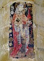 Wall painting, St Etheldreda's, Horley - geograph.org.uk - 3692275.jpg 1,177 × 1,600; 480 KB
-
 Wroxton Lane - geograph.org.uk - 2694580.jpg 640 × 480; 86 KB
-
 Bridge outside Horley - geograph.org.uk - 434176.jpg 640 × 480; 160 KB
-

-
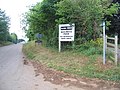 Glebe Farm Business Park - geograph.org.uk - 198025.jpg 640 × 480; 85 KB
-
 Horley Lane - geograph.org.uk - 116312.jpg 640 × 427; 78 KB


_-_geograph.org.uk_-_5099990.jpg)
_-_geograph.org.uk_-_5099995.jpg)
_-_geograph.org.uk_-_5099996.jpg)
_-_geograph.org.uk_-_5099997.jpg)
_-_geograph.org.uk_-_5100002.jpg)
_-_geograph.org.uk_-_5099998.jpg)
_-_geograph.org.uk_-_5099999.jpg)
_-_geograph.org.uk_-_5100000.jpg)
_-_geograph.org.uk_-_5100001.jpg)
_-_geograph.org.uk_-_5100003.jpg)
_-_geograph.org.uk_-_5100005.jpg)
_-_geograph.org.uk_-_5100006.jpg)
_-_geograph.org.uk_-_5100007.jpg)
_-_geograph.org.uk_-_5100008.jpg)
_-_geograph.org.uk_-_5100013.jpg)
_-_geograph.org.uk_-_5100014.jpg)


_-_geograph.org.uk_-_5099975.jpg)
_-_geograph.org.uk_-_5099976.jpg)
_-_geograph.org.uk_-_5099977.jpg)
_-_geograph.org.uk_-_5099979.jpg)
_-_geograph.org.uk_-_5099981.jpg)
_-_geograph.org.uk_-_5099982.jpg)
_-_geograph.org.uk_-_5099983.jpg)
_-_geograph.org.uk_-_5099984.jpg)
_-_geograph.org.uk_-_5099985.jpg)


_-_geograph.org.uk_-_5099991.jpg)
_-_geograph.org.uk_-_5099992.jpg)
_-_geograph.org.uk_-_5099993.jpg)
_-_geograph.org.uk_-_5099994.jpg)
_-_geograph.org.uk_-_5100009.jpg)
_-_geograph.org.uk_-_5099987.jpg)


