Category:Horní Heřmanice (Třebíč District)
Jump to navigation
Jump to search
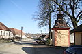
village in Třebíč District of Vysočina region  Centrum obce s kaplí Panny Marie   | |||||
| Upload media | |||||
| Instance of | |||||
|---|---|---|---|---|---|
| Location |
| ||||
| Population |
| ||||
| Area |
| ||||
| Elevation above sea level |
| ||||
| official website | |||||
 | |||||
Subcategories
This category has the following 7 subcategories, out of 7 total.
B
D
S
Media in category "Horní Heřmanice (Třebíč District)"
The following 2 files are in this category, out of 2 total.
-
 Center of Horní Heřmanice in 2015, Třebíč District.JPG 3,888 × 2,592; 4.74 MB
-
 Center with chapel of Saint Mary in Horní Heřmanice, Třebíč District.JPG 4,320 × 3,240; 3.89 MB
