Category:Huis Empe
Jump to navigation
Jump to search
| Object location | | View all coordinates using: OpenStreetMap |
|---|
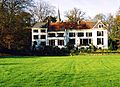
house in Brummen, Netherlands  | |||||
| Upload media | |||||
| Instance of | |||||
|---|---|---|---|---|---|
| Part of | |||||
| Location | Empe, Brummen, Gelderland, Netherlands | ||||
| Street address |
| ||||
| Located on street |
| ||||
| Heritage designation |
| ||||
 | |||||
Nederlands: Hoofdgebouw:
Daarnaast hebben diverse onderdelen een eigen Rijksmonumentnummer.
|
This is a category about rijksmonument number 510144
|
| Address |
|
Subcategories
This category has the following 2 subcategories, out of 2 total.
K
- Kassen, Huis Empe (21 F)
M
- Moestuin, Huis Empe (5 F)
Media in category "Huis Empe"
The following 17 files are in this category, out of 17 total.
-
 20140421 Huis Empe (achterzijde).jpg 4,896 × 3,672; 2.18 MB
-
 20140421 Huis Empe (voorzijde).jpg 4,817 × 3,613; 2.15 MB
-
 20140421 Huis Empe (windvaan).jpg 3,672 × 4,896; 540 KB
-
 Achterzijde huis Empe - Empe - 20405035 - RCE.jpg 1,197 × 1,200; 319 KB
-
 Empe bruggen.jpg 2,034 × 1,482; 1.02 MB
-
 Empe tuin.jpg 2,040 × 1,482; 780 KB
-
 Empe", achter - Brummen - 20044526 - RCE.jpg 1,200 × 807; 268 KB
-
 Empe", voor - Brummen - 20044525 - RCE.jpg 1,200 × 812; 213 KB
-
 Empe-huis.jpg 3,008 × 2,000; 6.53 MB
-
 Exterieur LINKER ZIJGEVEL - Brummen - 20311353 - RCE.jpg 1,177 × 1,200; 438 KB
-
 Exterieur OVERZICHT - Brummen - 20311351 - RCE.jpg 1,190 × 1,200; 484 KB
-
 Exterieur OVERZICHT - Brummen - 20311352 - RCE.jpg 1,183 × 1,200; 437 KB
-
 Exterieur OVERZICHT ACHTERGEVEL - Brummen - 20311354 - RCE.jpg 1,197 × 1,200; 404 KB
-
 Exterieur OVERZICHT ACHTERGEVEL - Brummen - 20311355 - RCE.jpg 1,188 × 1,200; 479 KB
-
 Exterieur OVERZICHT ACHTERGEVEL - Brummen - 20311356 - RCE.jpg 1,186 × 1,200; 444 KB
-
 Koetshuis bij Huis Empe.jpg 3,648 × 2,097; 1.66 MB
-
 Overzicht begroeiing waarachter het kassencomplex ligt - Empe - 20405037 - RCE.jpg 1,187 × 1,200; 370 KB
.jpg)
.jpg)
.jpg)


