Category:Hôtel de ville d'Avesnes-sur-Helpe
Jump to navigation
Jump to search
| Object location | | View all coordinates using: OpenStreetMap |
|---|
|
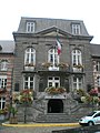
This building is classé au titre des monuments historiques de la France. It is indexed in the base Mérimée, a database of architectural heritage maintained by the French Ministry of Culture, under the reference PA00107354
|
 | |||||
| Upload media | |||||
| Instance of | |||||
|---|---|---|---|---|---|
| Location | Avesnes-sur-Helpe, canton of Avesnes-sur-Helpe-Nord | ||||
| Street address |
| ||||
| Owned by | |||||
| Operator | |||||
| Heritage designation |
| ||||
 | |||||
Media in category "Hôtel de ville d'Avesnes-sur-Helpe"
The following 2 files are in this category, out of 2 total.
-
 Mairie - Hôtel de ville.jpg 4,592 × 3,056; 6.09 MB
-
 Mairie Avesnes-sur-Helpe.JPG 2,112 × 2,816; 1.86 MB
