Category:Hördlertorstraße 16 (Schwabach)
Jump to navigation
Jump to search
| Object location | | View all coordinates using: OpenStreetMap |
|---|
 | |||||
| Upload media | |||||
| Instance of | |||||
|---|---|---|---|---|---|
| Location | Schwabach, Middle Franconia, Bavaria, Germany | ||||
| Street address |
| ||||
| Heritage designation | |||||
 | |||||
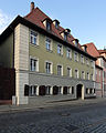
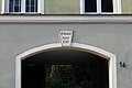
This is the category of the Bavarian Baudenkmal (cultural heritage monument) with the ID D-5-65-000-63 (Wikidata)
|
Deutsch: Schwabach - Hördlertorstraße 16 - Ehemalige Brauerei. Dreigeschossiger, stattlicher, Walmdachbau, im Kern Fachwerk, 1693.
Media in category "Hördlertorstraße 16 (Schwabach)"
The following 7 files are in this category, out of 7 total.
-
 Hördlertorstraße 16 Schwabach 20190626 001.jpg 5,316 × 3,549; 9.63 MB
-
 Schwabach - Hördlertorstraße 16 - 1.jpg 3,030 × 3,788; 3.42 MB
-
 Schwabach - Hördlertorstraße 16 - 2.jpg 2,858 × 3,572; 2.84 MB
-
 Schwabach - Hördlertorstraße 16 - Detail 1.jpg 4,972 × 3,315; 5.03 MB
-
 Schwabach, Hördlertorstraße 16-20160815-001.jpg 5,996 × 4,003; 10.79 MB
-
 Schwabach, Hördlertorstraße 16-20160815-002.jpg 5,996 × 4,003; 10.4 MB
-
 Schwabach, Hördlertorstraße 16-20160815-003.jpg 4,003 × 5,996; 10.84 MB


