Category:Islands of Ireland
Pereiti į navigaciją
Jump to search
Europos valstybės: Airija · Albanija · Armėnija‡ · Austrija · Azerbaidžanas‡ · Belgija · Bosnija ir Hercegovina · Bulgarija · Čekija · Danija · Estija · Graikija · Gruzija‡ · Islandija · Ispanija‡ · Italija · Jungtinė Karalystė · Juodkalnija · Kazachstanas‡ · Kipras‡ · Kroatija · Latvija · Lenkija · Lietuva · Malta · Norvegija · Nyderlandai‡ · Portugalija‡ · Prancūzija‡ · Rumunija · Rusija‡ · Serbija · Slovakija · Slovėnija · Suomija · Šiaurės Makedonija · Švedija · Šveicarija · Turkija‡ · Ukraina · Vengrija · Vokietija
Konkrečias statusas: Farerai · Džersis · Gernsis · Meno Sala · Svalbardas – Ribotas pripažinimas: Turkų Kipras‡
‡: partly located in Europe
Konkrečias statusas: Farerai · Džersis · Gernsis · Meno Sala · Svalbardas – Ribotas pripažinimas: Turkų Kipras‡
‡: partly located in Europe
Wikimedia category | |||||
| Įkelti mediją | |||||
| Tai yra | |||||
|---|---|---|---|---|---|
| Kategorija sujungia temas | |||||
| Airijos sala | |||||
island in the North Atlantic Ocean .jpg)   Kaart vun Irland | |||||
| Tarimas (garso failas) | |||||
| Tai yra | |||||
| Yra dalis | |||||
| Vieta | Britų salos, Europa, Šiaurės pusrutulis | ||||
| Yra prie arba vandens telkinyje | |||||
| Plotis |
| ||||
| Ilgis |
| ||||
| Aukščiausia vieta |
| ||||
| Gyventojų skaičius |
| ||||
| Plotas |
| ||||
| Skiriasi nuo | |||||
 | |||||
Multimedia files about Irish islands.
Subkategorijos
Rodoma 10 subkategorijų (iš viso yra 10 subkategorijų).
Daugialypės terpės rinkmenos kategorijoje „Islands of Ireland“
Rodomi 35 šios kategorijos rinkmenos (iš viso kategorijoje yra 35 rinkmenos).
-
 A man and the sea (269552564).jpg 1 840 × 1 240; 1,55 MiB
-
 Achillbeg.jpg 676 × 348; 136 KiB
-
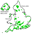 AONBSUK.png 886 × 915; 37 KiB
-
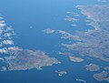 Arranmore, Co. Donegal (Aerial 2007).jpg 2 770 × 2 098; 1,86 MiB
-
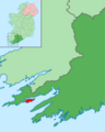 Bere Island within Ireland.png 1 450 × 1 806; 814 KiB
-
 Britske ostrovy 01.PNG 510 × 710; 16 KiB
-
 Bullock Island and entrance to Loch Hyne - geograph.org.uk - 97763.jpg 640 × 417; 67 KiB
-
 Bullock Island and Loch Hyne entrance - geograph.org.uk - 97770.jpg 640 × 401; 94 KiB
-
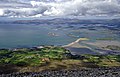 Clew Bay, June 2015.jpg 1 564 × 1 010; 2,01 MiB
-
 Coney Island Sign, Co. Sligo.jpg 4 032 × 3 024; 5,46 MiB
-
 End of Bartraw Strand - geograph.org.uk - 187233.jpg 640 × 480; 96 KiB
-
 Illaunglass - geograph.org.uk - 14837.jpg 640 × 480; 207 KiB
-
 Inchbofin, Lough Ree - geograph.org.uk - 412925.jpg 640 × 480; 57 KiB
-
 Inis Seimir Island.jpg 2 560 × 1 920; 1,41 MiB
-
 Island landscape island.jpg 1 050 × 700; 89 KiB
-

-

-
 Knocklane Promontory Fort.JPG 3 488 × 2 616; 1,43 MiB
-
 Long Hole-Ireland's Eye.jpg 560 × 595; 130 KiB
-
 Lough Gill - geograph.org.uk - 188480.jpg 640 × 480; 61 KiB
-
 Magharees kerry.jpg 5 136 × 1 940; 3,42 MiB
-
 Panorama Dursey Island.jpg 6 415 × 1 626; 2,09 MiB
-
 Skellig Michael map.png 4 320 × 4 320; 19,67 MiB
-
 Swan Island, Garadice Lough - geograph.org.uk - 1309575.jpg 640 × 480; 101 KiB
-
 That's some back garden... (8764827950).jpg 2 000 × 1 319; 1,28 MiB
-
 Tory Island 1.jpg 3 264 × 2 448; 4,82 MiB
-
 Tory Island 2.jpg 3 264 × 2 448; 4,81 MiB
-
 Tory Island 3.jpg 3 264 × 2 448; 4,63 MiB
-
 Tory Island 4.jpg 3 264 × 2 448; 4,89 MiB
-
 Tory Island 5.jpg 3 264 × 2 448; 4,38 MiB
-
 Tory Island Generators.jpg 3 264 × 2 448; 5,06 MiB
-
 Tory Island OpenStreetMaps.svg 2 963 × 1 958; 3,13 MiB
-
 View across Derrynane Harbour towards Denish and Scariff Island Co Kerry Ireland Aug16 2018.jpg 5 152 × 3 864; 7,13 MiB
-
 View from Beenarouke to Deenish and Scariff Island Co Kerry Ireland Aug13 2018.jpg 5 152 × 3 864; 6,93 MiB
-
 Cromwell Fort, Port Island, Inishbofin - geograph.org.uk - 199476.jpg 640 × 432; 90 KiB
.jpg)


.jpg)


.jpg)


