Category:Islands of Washington (state)
Zur Navigation springen
Zur Suche springen
Bundesstaaten der Vereinigten Staaten: Alabama · Alaska · Arizona · Arkansas · Colorado · Connecticut · Florida · Georgia · Hawaii · Idaho · Illinois · Indiana · Kalifornien · Louisiana · Maine · Maryland · Massachusetts · Michigan · Minnesota · Mississippi · Missouri · Montana · Nebraska · Nevada · New Hampshire · New Jersey · New York · North Carolina · Ohio · Oregon · Pennsylvania · Rhode Island · South Carolina · South Dakota · Tennessee · Texas · Utah · Vermont · Virginia · Washington · West Virginia · Wisconsin · Wyoming – District of Columbia: Washington, D.C.
Amerikanisch-Samoa · Amerikanische Jungferninseln · Nördliche Marianen · Puerto Rico – United States Minor Outlying Islands
Amerikanisch-Samoa · Amerikanische Jungferninseln · Nördliche Marianen · Puerto Rico – United States Minor Outlying Islands
Wikimedia-Kategorie | |||||
| Medium hochladen | |||||
| Ist ein(e) | |||||
|---|---|---|---|---|---|
| Kategorie kombiniert die Themen | |||||
| Washington | |||||
Bundesstaat der Vereinigten Staaten von Amerika someja satełitar in setenbre    | |||||
| Aussprache (Audiodatei) | |||||
| Ist ein(e) | |||||
| Ist Teil von | |||||
| Benannt nach | |||||
| Ort |
| ||||
| Liegt am oder im Gewässer | |||||
| Hauptstadt | |||||
| Gesetzgebende Körperschaft | |||||
| Exekutivorgan | |||||
| Höchstes Gericht | |||||
| Leiter der Regierung oder Verwaltung |
| ||||
| Datum der Gründung, Erstellung, Entstehung, Erbauung |
| ||||
| Höchster Punkt | |||||
| Einwohnerzahl |
| ||||
| Fläche |
| ||||
| Höhe über dem Meeresspiegel |
| ||||
| Ersetzt | |||||
| Verschieden von | |||||
| Höchsttemperatur |
| ||||
| Historische Tiefsttemperatur |
| ||||
| offizielle Website | |||||
 | |||||
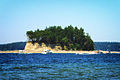
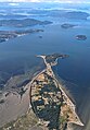
Most of Washington's islands are within Puget Sound.
Unterkategorien
Es werden 29 von insgesamt 29 Unterkategorien in dieser Kategorie angezeigt:
In Klammern die Anzahl der enthaltenen Kategorien (K), Seiten (S), Dateien (D)
*
A
- Allan Island, Washington (3 D)
B
- Blakely Island, Washington (11 D)
- Burrows Island, Washington (1 S, 4 D)
C
- Carroll Island (Washington) (14 D)
- Clark Island (1 D)
- Craft Island, Washington (1 S, 115 D)
D
E
- Edmount Island (4 D)
G
- Gedney Island (2 D)
- Guemes Island (5 D)
H
J
- Jetty Island (4 D)
M
O
- Obstruction Island (1 D)
- Ozette Island (6 D)
P
S
T
Medien in der Kategorie „Islands of Washington (state)“
Folgende 57 Dateien sind in dieser Kategorie, von 57 insgesamt.
-
 Alexander Island Washington.jpg 1.920 × 2.560; 1,56 MB
-
 Anacortes, WA - Island in Lake Campbell from Mount Erie.jpg 6.000 × 4.000; 11,51 MB
-
 Anacortes, WA - looking northwest from Mount Erie 01.jpg 6.000 × 4.000; 12,52 MB
-
 Anacortes, WA - looking northwest from Mount Erie 02.jpg 6.000 × 4.000; 11,48 MB
-
 Anacortes, WA - Mount Erie - pano 01.jpg 13.735 × 2.500; 17,14 MB
-
 Anacortes, WA - Mount Erie - pano 02.jpg 14.200 × 2.355; 17,37 MB
-
 Argus - A.Y.P. ed. - Page 12.jpg 4.711 × 6.854; 7,87 MB
-
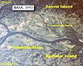 Bachelor and Sauvie Island map.jpg 500 × 400; 89 KB
-

-
 Blake Island in Puget Sound.jpg 2.203 × 1.369; 884 KB
-
 Chuckanut Island and Lion Rock.jpg 4.446 × 3.334; 3,14 MB
-
 Copalis NWR.jpg 512 × 219; 135 KB
-
 Cutts Island from Kopachuck State Park beach.jpg 1.529 × 1.019; 2,14 MB
-
 Cutts Island, 01.jpg 1.100 × 734; 1,14 MB
-
 Driftwood Shores Camano Island.jpg 2.272 × 1.507; 630 KB
-
 Eagle-Island-from-canoe.jpg 604 × 453; 63 KB
-
 Eastbound from Lopez Island 01.jpg 2.592 × 1.944; 669 KB
-
 Eastbound from Lopez Island 02.jpg 2.592 × 1.944; 675 KB
-
 Eastbound from Lopez Island 03.jpg 2.592 × 1.944; 619 KB
-
 Eastbound from Lopez Island 04.jpg 2.592 × 1.944; 643 KB
-
 Eastbound from Lopez Island 05.jpg 2.592 × 1.944; 681 KB
-
 Eastbound from Lopez Island 06.jpg 2.592 × 1.944; 614 KB
-
 Eliza Island with Lummi Island behind.jpg 4.080 × 3.072; 1,52 MB
-
 Eliza Island.jpg 497 × 292; 62 KB
-
 Friday Harbor.jpg 1.600 × 1.200; 905 KB
-
 Gulf Islands map 2 without border.png 801 × 871; 582 KB
-
 Gulf Islands map 2.png 801 × 871; 594 KB
-
 Jagged Island, Washington coast.jpeg 1.253 × 632; 548 KB
-
 James Islands and Western Gull.jpg 889 × 562; 141 KB
-
 James Islands seen from Rialto Beach. Washington coast.jpg 2.272 × 1.444; 1,02 MB
-
 James Islands seen from Rialto Beach.jpg 2.267 × 1.338; 885 KB
-
 Kopachuck State Park beach, 02.jpg 1.878 × 1.252; 3,41 MB
-
 Lake Campbell, ca. 1880 - DPLA - d3ba45e797bc843b7c654d1919d68acc.jpg 4.972 × 3.476; 1,67 MB
-
 Little James Island seen from La Push.jpg 2.272 × 1.426; 830 KB
-
 Looking north from south span of Deception Pass bridge 01.jpg 4.288 × 2.848; 6,88 MB
-
 Makah Ozette Longhouse Memorial site with Tskawahyah Island.jpg 4.032 × 3.024; 4,7 MB
-
 Moran - Mt. Constitution toward Clark Island.jpg 2.592 × 1.944; 699 KB
-
 Moran - Mt. Constitution toward Lummi Island 2.jpg 2.592 × 1.944; 835 KB
-
 Moran - Mt. Constitution toward Lummi Island.jpg 2.592 × 1.944; 700 KB
-
 Moran - Mt. Constitution toward Matos Island.jpg 2.592 × 1.944; 732 KB
-

-
 OrkilaSunset.jpg 2.048 × 1.536; 820 KB
-
 Point of the Arches, Washington - panoramio.jpg 2.560 × 1.920; 1,73 MB
-
 Popeye, official seal of Friday Harbor on San Juan Island, Washington.jpg 1.137 × 852; 361 KB
-
 Port of Friday Harbor.jpg 1.600 × 1.200; 1,02 MB
-
 Portage Island with Lummi Island behind.jpg 2.733 × 2.466; 1,15 MB
-
 Portageisland1.gif 600 × 600; 12 KB
-
 Quillayute Needles NWR.jpg 512 × 219; 82 KB
-
 Quinault River - Lake Quinault.jpg 2.560 × 1.920; 1,73 MB
-
 Rennie Island in Grays Harbor.jpg 978 × 624; 426 KB
-
 Salish Sea, probably Puget Sound, circa 1903.jpg 2.939 × 1.184; 398 KB
-
 Samish Island.jpg 2.724 × 3.909; 1,4 MB
-

-
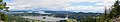
 Skagit, Hope, and Goat Islands from Mount Erie, Anacortes, WA.jpg 6.000 × 4.000; 9,62 MB
-
 Deception Pass 21.jpg 2.848 × 4.288; 6,6 MB
-
 Tskawahyah Island Olympic Coast National Marine Sanctuary 2009 .jpg 1.784 × 1.176; 253 KB
-
 View from Washington Park, Anacortes, WA.jpg 1.947 × 1.368; 2,34 MB


.jpeg)


.jpg)


.jpg)


