Category:Kaiser-Wilhelm-Turm (Bad Schmiedeberg)
Jump to navigation
Jump to search
| Object location | | View all coordinates using: OpenStreetMap |
|---|
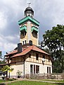
observation tower near Bad Schmiedeberg  | |||||
| Upload media | |||||
| Instance of | |||||
|---|---|---|---|---|---|
| Named after | |||||
| Made from material | |||||
| Location | Bad Schmiedeberg, Wittenberg, Saxony-Anhalt, Germany | ||||
| Heritage designation | |||||
| Height |
| ||||
 | |||||
This is the category of the Saxony-Anhalt Kulturdenkmal (cultural heritage monument) with the ID 09435422 (Wikidata)
|
Media in category "Kaiser-Wilhelm-Turm (Bad Schmiedeberg)"
The following 18 files are in this category, out of 18 total.
-
 AK-Bad-Schmiedeberg-Kaiser-Wilhelm-Aussichtsturm 1920.jpg 511 × 800; 121 KB
-
 Bad Schmiedeberg - Weinbergstraße + Kaiser-Wilhelm-Turm 01 ies.jpg 5,616 × 3,744; 21.25 MB
-
 Bad Schmiedeberg - Weinbergstraße + Kaiser-Wilhelm-Turm 02 ies.jpg 5,616 × 3,745; 21.33 MB
-
 Bad Schmiedeberg - Weinbergstraße - Kaiser-Wilhelm-Turm 01 ies.jpg 3,744 × 5,616; 22.59 MB
-
 Bad Schmiedeberg - Weinbergstraße - Kaiser-Wilhelm-Turm 02 ies.jpg 3,743 × 5,616; 17.92 MB
-
 Bad Schmiedeberg - Weinbergstraße - Kaiser-Wilhelm-Turm 03 ies.jpg 5,616 × 3,744; 19.55 MB
-
 Bad Schmiedeberg - Weinbergstraße - Kaiser-Wilhelm-Turm 04 ies.jpg 5,616 × 3,744; 17.43 MB
-
 Bad Schmiedeberg - Weinbergstraße - Kaiser-Wilhelm-Turm 05 ies.jpg 3,744 × 5,616; 17.59 MB
-
 Bad Schmiedeberg - Weinbergstraße - Kaiser-Wilhelm-Turm 06 ies.jpg 3,745 × 5,616; 17.23 MB
-
 Bad Schmiedeberg.jpg 2,560 × 1,920; 949 KB
-
 Borkenhäuschen.jpg 600 × 433; 42 KB
-
 K.W.-Turm 2010.jpg 2,560 × 1,920; 870 KB
-
 K.W.-Turm 2020.jpg 1,200 × 1,588; 333 KB
-
 Kaiser-Wilhelm-Turm Bad Schmiedeberg.jpg 2,128 × 2,832; 1,013 KB
-
 Kaiser-Wilhelm-Turm1 - panoramio.jpg 1,943 × 2,022; 2.18 MB
-
 Kaiser-Wilhelm-Turm2 - panoramio.jpg 2,413 × 2,158; 3.02 MB
-
 Weinbergstraße 33 (Bad Schmiedeberg ) (cropped).jpg 2,008 × 1,130; 2.47 MB
-
 Weinbergstraße 33 (Bad Schmiedeberg) Gaststätte (cropped).jpg 1,185 × 876; 245 KB


_(cropped).jpg)
_Gastst%C3%A4tte_(cropped).jpg)
Categories:
- Towers in Bad Schmiedeberg
- Towers named after people
- Cultural heritage monuments in Bad Schmiedeberg
- Weinbergstraße (Bad Schmiedeberg)
- Observation towers in Landkreis Wittenberg
- Monuments of Wilhelm I of Germany in Saxony-Anhalt
- Built in Saxony-Anhalt in 1910
- 1910 monuments and memorials
- Stone towers in Saxony-Anhalt
- Tetragonal towers in Saxony-Anhalt
- 30-meter-tall buildings in Germany
- Buildings named after monarchs
- Things named after William I, German Emperor