Category:Kapelle St. Barbara (Schwandorf)
Jump to navigation
Jump to search
This is the category of the Bavarian Baudenkmal (cultural heritage monument) with the ID D-3-76-161-31 (Wikidata)
|
| Object location | | View all coordinates using: OpenStreetMap |
|---|
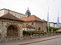
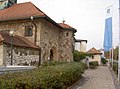
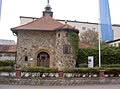
building in Schwandorf, Upper Palatinate, Germany | |||||
| Upload media | |||||
| Instance of | |||||
|---|---|---|---|---|---|
| Location | Schwandorf, Upper Palatinate, Bavaria, Germany | ||||
| Street address |
| ||||
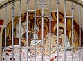
| Has part(s) |
| ||||
| Heritage designation | |||||
 | |||||
Media in category "Kapelle St. Barbara (Schwandorf)"
The following 16 files are in this category, out of 16 total.
-
 SchwandorfKapelleStBarbara 01.jpg 2,304 × 1,704; 881 KB
-
 SchwandorfKapelleStBarbara 02.jpg 2,304 × 1,704; 727 KB
-
 SchwandorfKapelleStBarbara 03.jpg 2,304 × 1,704; 918 KB
-
 SchwandorfKapelleStBarbara 04.jpg 2,304 × 1,704; 772 KB
-
 SchwandorfKapelleStBarbara 05.jpg 2,304 × 1,704; 828 KB
-
 SchwandorfKapelleStBarbara 06.jpg 2,304 × 1,704; 933 KB
-
 SchwandorfKapelleStBarbara 07.jpg 2,304 × 1,704; 899 KB
-
 SchwandorfKapelleStBarbara 08.jpg 2,304 × 1,704; 840 KB
-
 SchwandorfKapelleStBarbara 09.jpg 2,304 × 1,704; 780 KB
-
 SchwandorfKapelleStBarbara 10.jpg 2,304 × 1,704; 852 KB
-
 SchwandorfKapelleStBarbara 11.jpg 2,304 × 1,704; 834 KB
-
 SchwandorfKapelleStBarbara 12.jpg 2,304 × 1,704; 883 KB
-
 SchwandorfKapelleStBarbara 13.jpg 2,304 × 1,704; 771 KB
-
 SchwandorfKapelleStBarbara 14.jpg 2,304 × 1,704; 887 KB
-
 SchwandorfKapelleStBarbara 15.jpg 2,304 × 1,704; 914 KB
-
 SchwandorfKapelleStBarbara 16.jpg 2,304 × 1,704; 835 KB


