Category:Kasteel Ravenhof (Stabroek)
Jump to navigation
Jump to search
| Object location | | View all coordinates using: OpenStreetMap |
|---|
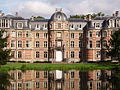
Nederlands: Afbeeldingen van het Kasteel Ravenhof Stabroek, Oud Broek 4, 2940 Stabroek België. Gelegen in de gemeente Stabroek in het noorden van de provincie Antwerpen in België.
Nabij Putte. Kasteel Ravenhof is gebouwd begin 19de eeuw (middendeel) en begin 20ste eeuw, in neo-rococostijl. Tot het kasteel behoort, op Belgisch grondgebied, een 25 ha groot, vrij toegankelijk park met de theekoepel de Gloriëtte op Nederlands grondgebied (bron [1]; [2];[3])
|
This is a category about onroerend erfgoed number 14212
|
castle in Stabroek, Belgium  | |||||
| Upload media | |||||
| Instance of | |||||
|---|---|---|---|---|---|
| Location | Stabroek, Arrondissement of Antwerp, Province of Antwerp, Flemish Region, Belgium | ||||
| Street address |
| ||||
| Architectural style |
| ||||
| Architect |
| ||||
| Heritage designation | |||||
| Inception |
| ||||
 | |||||
Media in category "Kasteel Ravenhof (Stabroek)"
The following 30 files are in this category, out of 30 total.
-
 Stabroek Ravenhof 28.JPG 2,560 × 1,920; 1.94 MB
-
 Kasteel Ravenhof - 353460 - onroerenderfgoed.jpg 3,060 × 4,202; 1.34 MB
-
 Putte ravenhof.JPG 640 × 480; 149 KB
-
 Ravenhof.JPG 4,320 × 3,240; 4.77 MB
-
 Stabroek Ravenhof 1.psd.jpg 4,493 × 1,990; 4.96 MB
-
 Stabroek Ravenhof 10.JPG 2,560 × 1,920; 1.89 MB
-
 Stabroek Ravenhof 11.JPG 2,560 × 1,920; 1.94 MB
-
 Stabroek Ravenhof 12.JPG 2,558 × 1,836; 2.18 MB
-
 Stabroek Ravenhof 13.JPG 2,560 × 1,920; 2.07 MB
-
 Stabroek Ravenhof 14.psd.jpg 2,560 × 1,920; 2.55 MB
-
 Stabroek Ravenhof 15.JPG 1,920 × 2,560; 1.98 MB
-
 Stabroek Ravenhof 16.JPG 1,920 × 2,560; 2.06 MB
-
 Stabroek Ravenhof 17.JPG 1,920 × 2,560; 2.01 MB
-
 Stabroek Ravenhof 18.JPG 1,920 × 2,560; 2.13 MB
-
 Stabroek Ravenhof 19.JPG 1,920 × 2,560; 2.09 MB
-
 Stabroek Ravenhof 2.JPG 2,560 × 1,920; 1.87 MB
-
 Stabroek Ravenhof 20.JPG 2,560 × 1,853; 1.99 MB
-
 Stabroek Ravenhof 21.JPG 2,560 × 1,920; 1.81 MB
-
 Stabroek Ravenhof 29.JPG 1,920 × 2,560; 1.98 MB
-
 Stabroek Ravenhof 3.JPG 2,560 × 1,920; 2.06 MB
-
 Stabroek Ravenhof 30.JPG 2,560 × 1,920; 2.17 MB
-
 Stabroek Ravenhof 31.JPG 2,560 × 1,920; 1.77 MB
-
 Stabroek Ravenhof 32.JPG 1,920 × 2,560; 3.43 MB
-
 Stabroek Ravenhof 33.JPG 1,920 × 2,560; 1.82 MB
-
 Stabroek Ravenhof 4.JPG 2,560 × 1,920; 1.95 MB
-
 Stabroek Ravenhof 5.JPG 2,560 × 1,920; 1.85 MB
-
 Stabroek Ravenhof 6.JPG 2,560 × 1,920; 1.87 MB
-
 Stabroek Ravenhof 7.JPG 2,560 × 1,920; 1.94 MB
-
 Stabroek Ravenhof 8.JPG 2,560 × 1,920; 2.02 MB
-
 Stabroek Ravenhof 9.psd.jpg 2,560 × 1,920; 2.11 MB


