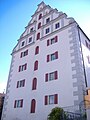
Category:Kastenhaus Höchstädt
Jump to navigation
Jump to search
| Object location | | View all coordinates using: OpenStreetMap |
|---|
| Upload media | |||||
| Instance of | |||||
|---|---|---|---|---|---|
| Location | Höchstädt an der Donau, Dillingen, Swabia, Bavaria, Germany | ||||
| Street address |
| ||||
| Has part(s) |
| ||||
| Heritage designation | |||||
 | |||||
This is the category of the Bavarian Baudenkmal (cultural heritage monument) with the ID D-7-73-130-16 (Wikidata)
|
Media in category "Kastenhaus Höchstädt"
The following 9 files are in this category, out of 9 total.
-
 Höchstädt Kastenhaus 565.jpg 4,770 × 3,180; 9.47 MB
-
 Höchstädt Kastenhaus 566.jpg 4,896 × 3,264; 9.41 MB
-
 Höchstädt Kastenhaus 567.jpg 3,264 × 4,896; 9.49 MB
-
 Höchstädt Kastenhaus 568.jpg 3,805 × 2,536; 6.48 MB
-
 Höchstädt Kastenhaus.jpg 1,728 × 1,951; 299 KB
-
 Höchstädter Kastenhaus.jpg 2,139 × 1,729; 327 KB
-
 Kastenhaus Höchstädt.jpg 1,728 × 2,304; 302 KB
-
 Nordseite Kastenhaus.jpg 1,728 × 2,304; 1.5 MB
-
 Ostseite Kastenhaus.jpg 1,728 × 2,304; 1.44 MB


