Category:Kerk, Wijnjeterp
Jump to navigation
Jump to search
| Object location | | View all coordinates using: OpenStreetMap |
|---|
church building in Opsterland, Netherlands  | |||||
| Upload media | |||||
| Instance of | |||||
|---|---|---|---|---|---|
| Dedicated to | |||||
| Location | Wijnjewoude, Opsterland, Friesland, Netherlands | ||||
| Street address |
| ||||
| Located on street |
| ||||
| Heritage designation |
| ||||
| Inception |
| ||||
| Significant event |
| ||||
| official website | |||||
 | |||||
|
This is a category about rijksmonument number 31869
|
| Address |
|
Media in category "Kerk, Wijnjeterp"
The following 22 files are in this category, out of 22 total.
-
 2023 Weinterp, klokkestoel.jpg 1,838 × 1,841; 813 KB
-
 2023 Weinterper Nikolaastsjerke.jpg 1,896 × 1,895; 1.46 MB
-
 2023 Weinterper tsjerke.jpg 2,275 × 1,514; 1.37 MB
-
 Exterieur zuid-gevel - Wijnjeterp - 20213917 - RCE.jpg 1,200 × 944; 188 KB
-
 Houtsnijwerk bank - Wijnjeterp - 20213915 - RCE.jpg 953 × 1,200; 155 KB
-
 Houtsnijwerk bank - Wijnjeterp - 20213916 - RCE.jpg 961 × 1,200; 149 KB
-
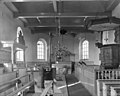 Interieur naar het oosten - Wijnjeterp - 20213918 - RCE.jpg 1,200 × 958; 179 KB
-
 Interieur naar het westen - Wijnjeterp - 20213912 - RCE.jpg 1,200 × 951; 212 KB
-
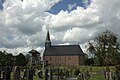
 Kerk en klokkestoel - Wijnjeterp - 20213907 - RCE.jpg 1,200 × 1,199; 296 KB
-
 Kerk en klokkestoel - Wijnjeterp - 20213908 - RCE.jpg 1,199 × 1,200; 239 KB
-
 Kerk en klokkestoel - Wijnjeterp - 20213909 - RCE.jpg 1,200 × 1,199; 231 KB
-
 Kerk en klokkestoel - Wijnjeterp - 20213910 - RCE.jpg 1,200 × 1,200; 224 KB
-
 Kerk Wijnjewoude..JPG 2,592 × 1,944; 875 KB
-
 Klokkenstoel Wijnjewoude 09cw.JPG 575 × 768; 72 KB
-
 Noord-gevel - Wijnjeterp - 20213913 - RCE.jpg 960 × 1,200; 222 KB
-
 Oost-zijde - Wijnjeterp - 20213914 - RCE.jpg 1,200 × 957; 211 KB
-

-

-
 Preekstoel - Wijnjeterp - 20213911 - RCE.jpg 952 × 1,200; 178 KB
-
 Tsjerke fan Weinterp, gevelstien.jpg 2,905 × 2,459; 3.12 MB
-
 Tsjerke fan Weinterp.jpg 5,197 × 3,545; 9.28 MB
-
 Wijjewoude..jpg 4,770 × 3,177; 4.05 MB


