Category:Kerkstraat 29, Vollenhove
Jump to navigation
Jump to search
| Object location | | View all coordinates using: OpenStreetMap |
|---|
building in Steenwijkerland, Netherlands  | |||||
| Upload media | |||||
| Instance of | |||||
|---|---|---|---|---|---|
| Location | Vollenhove, Vollenhove | ||||
| Street address |
| ||||
| Located on street |
| ||||
| Heritage designation |
| ||||
 | |||||
|
This is a category about rijksmonument number 10561
|
| Address |
|
Media in category "Kerkstraat 29, Vollenhove"
The following 8 files are in this category, out of 8 total.
-
 Achtergevels - Vollenhove - 20245161 - RCE.jpg 948 × 1,200; 294 KB
-
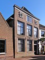 Kerkstraat29 Vollenhove.jpg 1,368 × 1,824; 385 KB
-
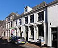 Kerkstraat31 Vollenhove.jpg 1,612 × 1,336; 222 KB
-

-
 Vollenhove 063.JPG 2,448 × 3,264; 1.89 MB
-
 Vollenhove 069.JPG 3,264 × 2,448; 1.85 MB
-
 Voorgevel - Vollenhove - 20245162 - RCE.jpg 805 × 1,200; 208 KB
-
 Voorgevels - Vollenhove - 20245159 - RCE.jpg 953 × 1,200; 311 KB


