Category:Kerkstraat 30, Vollenhove
Jump to navigation
Jump to search
| Object location | | View all coordinates using: OpenStreetMap |
|---|
building in Steenwijkerland, Netherlands  | |||||
| Upload media | |||||
| Instance of | |||||
|---|---|---|---|---|---|
| Location | Vollenhove, Vollenhove | ||||
| Street address |
| ||||
| Located on street |
| ||||
| Heritage designation |
| ||||
 | |||||
|
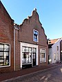
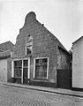
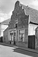
This is a category about rijksmonument number 10562
|
| Address |
|
Media in category "Kerkstraat 30, Vollenhove"
The following 15 files are in this category, out of 15 total.
-
 Achtergevel - Vollenhove - 20245167 - RCE.jpg 1,200 × 960; 278 KB
-
 Detail linker zijgevel - Vollenhove - 20245165 - RCE.jpg 959 × 1,200; 308 KB
-
 Detail linker zijgevel - Vollenhove - 20245166 - RCE.jpg 949 × 1,200; 303 KB
-
 Detail zolder - Vollenhove - 20245172 - RCE.jpg 1,192 × 1,200; 292 KB
-
 Detail zolder - Vollenhove - 20245173 - RCE.jpg 1,200 × 1,200; 291 KB
-
 Kelder - Vollenhove - 20245175 - RCE.jpg 1,200 × 1,192; 304 KB
-
 Kelder - Vollenhove - 20245176 - RCE.jpg 1,200 × 1,197; 324 KB
-
 Kelder - Vollenhove - 20245177 - RCE.jpg 1,195 × 1,200; 314 KB
-
 Kerkstraat30 Vollenhove.jpg 1,368 × 1,824; 287 KB
-
 Linker zijgevel - Vollenhove - 20245164 - RCE.jpg 950 × 1,200; 298 KB
-
 Voorgevel - Vollenhove - 20245163 - RCE.jpg 943 × 1,200; 196 KB
-
 Voorgevel - Vollenhove - 20245168 - RCE.jpg 804 × 1,200; 167 KB
-
 Zolder - Vollenhove - 20245169 - RCE.jpg 1,200 × 1,200; 294 KB
-
 Zolder - Vollenhove - 20245170 - RCE.jpg 1,200 × 1,200; 283 KB
-
 Zolder - Vollenhove - 20245171 - RCE.jpg 1,200 × 1,190; 299 KB


