Category:Kerkstraat 56, Vollenhove
Jump to navigation
Jump to search
| Object location | | View all coordinates using: OpenStreetMap |
|---|
 | |||||
| Upload media | |||||
| Instance of |
| ||||
|---|---|---|---|---|---|
| Location | Vollenhove, Vollenhove | ||||
| Street address |
| ||||
| Located on street |
| ||||
| Heritage designation |
| ||||
 | |||||
|
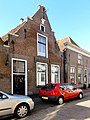
This is a category about rijksmonument number 10570
|
| Address |
|
Media in category "Kerkstraat 56, Vollenhove"
The following 3 files are in this category, out of 3 total.
-
 Gevelsteen met smeedijzeren jaaranker 1664 - Vollenhove - 20509813 - RCE.jpg 1,200 × 900; 124 KB
-
 Kerkstraat56 Vollenhove.jpg 1,368 × 1,824; 279 KB
-
 Voorgevel - Vollenhove - 20245185 - RCE.jpg 810 × 1,200; 183 KB

