Category:Kirche (Hohen Neuendorf)
Jump to navigation
Jump to search
| Object location | | View all coordinates using: OpenStreetMap |
|---|
church building in Brandenburg state, Germany    | |||||
| Upload media | |||||
| Instance of | |||||
|---|---|---|---|---|---|
| Location | Hohen Neuendorf, Oberhavel District, Brandenburg, Germany | ||||
| Heritage designation | |||||
 | |||||
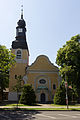
English: Village church, Hohen Neuendorf city, Oberhavel district, Brandenburg state, Germany
Deutsch: Dorfkirche Hohen Neuendorf, Stadt Hohen Neuendorf, Landkreis Oberhavel, Land Brandenburg, Deutschland
Français : Église de Hohen Neuendorf, ville de Hohen Neuendorf, arrondissement Haute-Havel, état fédéral de Brandebourg, Allemagne
This is the category of the Brandenburger Baudenkmal (cultural heritage monument) with the ID 09165359 (Wikidata)
|
Subcategories
This category has only the following subcategory.
I
Media in category "Kirche (Hohen Neuendorf)"
The following 27 files are in this category, out of 27 total.
-
 05012514kirchew.jpg 600 × 437; 64 KB
-
 Dorfkirche Hohen Neuendorf Gedenktafel Ernst Flatow Emma Rosenthal.jpg 3,613 × 2,948; 4.15 MB
-
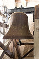
 Dorfkirche Hohen Neuendorf Glocke1.jpg 3,456 × 5,184; 6.89 MB
-
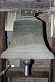
 Dorfkirche Hohen Neuendorf Glocke2.jpg 3,456 × 5,184; 6.05 MB
-
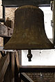
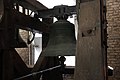 Dorfkirche Hohen Neuendorf Glocke3.jpg 5,184 × 3,456; 6.29 MB
-
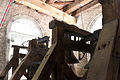
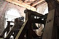 Dorfkirche Hohen Neuendorf Glockenstuhl.jpg 5,184 × 3,456; 6.05 MB
-
 Dorfkirche Hohen-Neuendorf Nordseite.jpg 5,184 × 3,456; 10.35 MB
-
 Dorfkirche Hohen-Neuendorf Ostseite.jpg 3,456 × 5,184; 8.43 MB
-
 Dorfkirche Hohen-Neuendorf Portal.jpg 5,184 × 3,456; 8.37 MB
-
 Dorfkirche Hohen-Neuendorf Südseite.jpg 5,184 × 3,456; 10.64 MB
-
 Dorfkirche Hohen-Neuendorf Südwestseite.jpg 3,456 × 5,184; 7.59 MB
-
 Dorfkirche Hohen-Neuendorf-Giesserzeichen-kleine Glocke.jpg 2,590 × 1,146; 2.81 MB
-
 Dorfkirche Hohen-Neuendorf-Glockenstuhl.jpg 5,184 × 3,456; 10.67 MB
-
 Dorfkirche Hohen-Neuendorf-große Glocke.jpg 3,456 × 5,184; 12.05 MB
-
 Dorfkirche Hohen-Neuendorf-kleine Glocke.jpg 3,456 × 5,184; 9.79 MB
-
 Dorfkirche Hohen-Neuendorf-mittlere Glocke.jpg 3,456 × 5,184; 11.09 MB
-
 Dorfkirche Hohen-Neuendorf-Programm Grundsteinlegung.pdf 1,239 × 1,754, 2 pages; 1.03 MB
-
 Gedenkplakette Turm Dorkirche Hohen Neuendorf.png 3,029 × 2,140; 5.72 MB
-
 Giesserzeichen grosse und kleine Glocke.jpg 5,184 × 3,456; 1.24 MB
-
 Hohen Neuendorf - panoramio.jpg 4,000 × 3,000; 6.23 MB
-
 Hohen Neuendorf Dorfkirche.jpg 2,615 × 3,378; 5.14 MB
-
 Hohen Neuendorf-Dorfkirche-Postkartenansicht von 1908.jpg 339 × 545; 96 KB
-
 Innenansicht Dorfkirche Hohen Neuendorf.jpg 50,222 × 25,111; 1.23 GB
-
 Kirche Hohen Neuendorf.jpg 292 × 305; 95 KB
-
 Verkleinert Glockenstube Dorfkirche Hohen Neuendorf.jpg 12,630 × 6,315; 92.57 MB
-
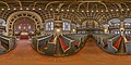 Verkleinert Innenansicht Dorfkirche Hohen Neuendorf.jpg 14,142 × 7,071; 103.67 MB
-
 Verkleinert Seitenempore Dorfkirche Hohen Neuendorf.jpg 14,142 × 7,071; 86.28 MB


