Category:Kirchplatz 19 (Hattingen)
Jump to navigation
Jump to search
| Object location | | View all coordinates using: OpenStreetMap |
|---|
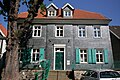
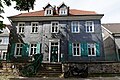
This is the category for an architectural monument.
It is on the list of cultural monuments of Hattingen, no. A-021.
It is on the list of cultural monuments of Hattingen, no. A-021.
Media in category "Kirchplatz 19 (Hattingen)"
The following 4 files are in this category, out of 4 total.
-
 Hattingen - Kirchplatz 07 ies.jpg 3,888 × 2,592; 2.1 MB
-
 Hattingen - Kirchplatz 08 ies.jpg 3,888 × 2,592; 1.76 MB
-
 Hattingen Kirchplatz 19.jpg 4,083 × 2,722; 2.79 MB
-
 Hattingen-Kirchplatz 19.jpg 4,608 × 3,456; 4.16 MB


