Category:Kirchstraße 26 (Impflingen)
Jump to navigation
Jump to search
This is the category for a cultural monument.
It is on the list of cultural monuments of Impflingen.
It is on the list of cultural monuments of Impflingen.
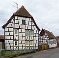
![]() Kirchstraße 26, baroque farmstead, half-timbered house, 18th century.
Kirchstraße 26, baroque farmstead, half-timbered house, 18th century.
| Object location | | View all coordinates using: OpenStreetMap |
|---|
Media in category "Kirchstraße 26 (Impflingen)"
The following 3 files are in this category, out of 3 total.
-
 049 2016 02 14 Kulturdenkmaeler Impflingen.jpg 2,269 × 2,203; 2.94 MB
-
 050 2016 02 14 Kulturdenkmaeler Impflingen.jpg 2,261 × 2,211; 3.65 MB
-
 051 2016 02 14 Kulturdenkmaeler Impflingen.jpg 2,143 × 2,332; 3.61 MB


