Category:Klosterkirche (Himmelpfort)
Jump to navigation
Jump to search
| Object location | | View all coordinates using: OpenStreetMap |
|---|
church building in Brandenburg state, Germany  _Kloster_Kirche.jpg) | |||||
| Upload media | |||||
| Instance of | |||||
|---|---|---|---|---|---|
| Part of | |||||
| Location | Himmelpfort, Fürstenberg/Havel, Oberhavel District, Brandenburg, Germany | ||||
| Heritage designation | |||||
 | |||||
This is the category of the Brandenburger Baudenkmal (cultural heritage monument) with the ID 09165173 (Wikidata)
|
Deutsch: Die Klosterkirche in Himmelpfort (zu Fürstenberg an der Havel), Mark Brandenburg, gehört und dient einer lutherischen Gemeinde der unierten Evangelischen Kirche Berlin-Brandenburg-Schlesische Oberlausitz. Bau und Kirchenname gehen auf die Zisterze an dieser Stelle zurück.
English: The Abbey Church in Himmelpfort (literally Heaven's Gate, a locality of Fürstenberg upon Havel), Brandenburg, Germany, is owned and used by a Lutheran congregation within the Evangelical Church of Berlin-Brandenburg-Silesian Upper Lusatia, a united Protestant church body of Calvinist, Lutheran and united congregations. The structure and name derives from the cloister of the former Cistercian monk monastery at this location.
Subcategories
This category has only the following subcategory.
I
Media in category "Klosterkirche (Himmelpfort)"
The following 16 files are in this category, out of 16 total.
-
 19870516160NR Himmelpfort (Fürstenberg Havel) Kloster Kirche.jpg 3,579 × 3,448; 7.53 MB
-
 19870516165NR Himmelpfort (Fürstenberg Havel) Kloster Kirche.jpg 3,716 × 2,880; 6.39 MB
-
 20010830200NR Kloster Himmelpfort.jpg 3,600 × 2,391; 8.17 MB
-
 20010830250NR Kloster Himmelpfort Kirche.jpg 3,497 × 2,130; 7.24 MB
-
 DSD Plakette.jpg 1,521 × 780; 176 KB
-
 Himmelpfort Klosteranlage und Kirche.jpg 1,600 × 1,200; 533 KB
-
 Himmelpfort Klosterruine.png 260 × 154; 96 KB
-
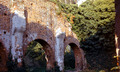
 Himmelpfort Ruinen-Zisterzienserkloster.jpg 1,280 × 960; 479 KB
-
 Interior of Klosterkirche (Himmelpfort)-msu-2024-2183-2183.jpg 6,000 × 4,000; 12.22 MB
-
 Kloster Himmelpfort 1975 0051.png 1,079 × 689; 1.31 MB
-
 Kloster Himmelpfort 1975 0052.png 1,079 × 677; 1.51 MB
-
 Kloster Himmelpfort 1975 0053.png 1,081 × 653; 1.29 MB
-
 Kloster-Himmelpfort-Kirche-22-04-2008-079.jpg 1,024 × 768; 595 KB
-
 Kloster-Himmelpfort-Kirche-Gesamtansicht-22-04-2008-101.jpg 1,024 × 768; 499 KB
-
 Kloster-Himmelpfort-Kirche-Hauptschiffruine-22-04-2008-093.jpg 1,024 × 768; 549 KB
-
 Klosterkirche (Himmelpfort)-msu-2024-2287-.jpg 6,000 × 4,000; 12.59 MB
_Kloster_Kirche.jpg)
_Kloster_Kirche.jpg)


-msu-2024-2183-2183.jpg)


-msu-2024-2287-.jpg)
Categories:
- Kloster Himmelpfort
- Churches in Fürstenberg/Havel
- Churches in Kirchenkreis Oberes Havelland
- Lutheran churches in Brandenburg
- Cistercian churches in Germany
- Monastery churches in Brandenburg
- Brick Gothic churches in Brandenburg
- Brick Gothic basilicas in Germany
- Architectural basilicas in Brandenburg
- 14th-century churches in Brandenburg
- Deutsche Stiftung Denkmalschutz