Category:Koepelgevangenis, Arnhem
Jump to navigation
Jump to search
| Object location | | View all coordinates using: OpenStreetMap |
|---|
 | |||||
| Upload media | |||||
| Instance of | |||||
|---|---|---|---|---|---|
| Part of | |||||
| Location | Arnhem, Gelderland, Netherlands | ||||
| Street address |
| ||||
| Heritage designation |
| ||||
 | |||||
|
This is a category about rijksmonumentcomplex number 516730
|
Cellengebouw:
|
This is a category about rijksmonument number 516731
|
Administratiegebouw:
|
This is a category about rijksmonument number 516732
|
Poortgebouw en ringmuur:
|
This is a category about rijksmonument number 516733
|
| Address |
|
Media in category "Koepelgevangenis, Arnhem"
The following 36 files are in this category, out of 36 total.
-
 Allround - Flickr - Rob Oo.jpg 5,426 × 3,617; 13.11 MB
-
 Arnhem - Koepelgevangenis1.jpg 2,592 × 1,944; 974 KB
-
 Arnhem - Wilhelminastraat bij 16 - Administratiegebouw - 1.jpg 2,592 × 1,944; 1.75 MB
-
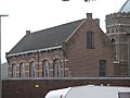 Arnhem - Wilhelminastraat bij 16 - Administratiegebouw - 2.jpg 2,592 × 1,944; 1.42 MB
-
 Arnhem - Wilhelminastraat bij 16 - Cellencomplex - 1.jpg 2,592 × 1,944; 1.3 MB
-
 Arnhem - Wilhelminastraat bij 16 - Cellencomplex - 2.jpg 2,592 × 1,944; 1,013 KB
-
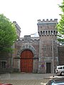 Arnhem - Wilhelminastraat bij 16 - Poort - 1.jpg 1,944 × 2,592; 1.3 MB
-
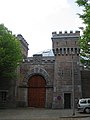 Arnhem - Wilhelminastraat bij 16 - Poort - 2.jpg 1,944 × 2,592; 1.15 MB
-
 Arnhem - Wilhelminastraat bij 16 - Poort - 4.jpg 1,944 × 2,592; 1.05 MB
-
 Arnhem Rijnkade 1963.jpg 2,436 × 1,808; 572 KB
-
 Bovenaanzicht vanaf zendmast - Arnhem - 20365904 - RCE.jpg 1,200 × 783; 187 KB
-
 Bovenaanzicht vanaf zendmast - Arnhem - 20365905 - RCE.jpg 1,200 × 783; 209 KB
-
 Bovenaanzicht vanaf zendmast - Arnhem - 20365906 - RCE.jpg 1,200 × 783; 201 KB
-

-
 Exterieur OVERZICHT COMPLEX - Arnhem - 20339604 - RCE.jpg 1,197 × 1,200; 291 KB
-
 Exterieur OVERZICHT GEVEL - Arnhem - 20339603 - RCE.jpg 1,184 × 1,200; 275 KB
-
 Exterieur OVERZICHT GEVEL - Arnhem - 20339605 - RCE.jpg 1,181 × 1,200; 249 KB
-

-

-

-

-

-

-
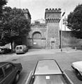 Exterieur TOEGANGSPOORT (1887), VOORZIJDE - Arnhem - 20339599 - RCE.jpg 1,165 × 1,200; 331 KB
-
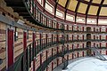
 Interieur Koepelgevangenis Arnhem 2.jpg 3,543 × 2,362; 6.63 MB
-
 Interieur Koepelgevangenis Arnhem.jpg 3,543 × 2,362; 6.49 MB
-
 Koepel Arnhem, exterieur.jpg 3,543 × 2,362; 7.28 MB
-
 Koepelgevangenis - panoramio.jpg 1,944 × 2,592; 1.98 MB
-
 Koepelgevangenis en Rijn - Arnhem mei 2007.jpg 2,592 × 1,944; 2.08 MB
-
 Mei 2010 042.jpg 2,592 × 1,944; 1.32 MB
-
 Overzicht met hoektorens - Arnhem - 20345322 - RCE.jpg 1,190 × 1,200; 365 KB
-
 Overzicht met hoektorens - Arnhem - 20345324 - RCE.jpg 1,192 × 1,200; 342 KB
-
 Overzicht met wachttoren met kantelen - Arnhem - 20345321 - RCE.jpg 1,192 × 1,200; 329 KB
-
 Poort Koepelgevangenis Arnhem.jpg 3,543 × 2,362; 7.66 MB
-

-


_STRAALVERBINDINGSTOREN_(110_METER_HOOGTE)_-_Arnhem_-_20339600_-_RCE.jpg)
_STRAALVERBINDINGSTOREN_(110_METER_HOOGTE)_-_Arnhem_-_20339606_-_RCE.jpg)
_STRAALVERBINDINGSTOREN_(110_METER_HOOGTE)_-_Arnhem_-_20339607_-_RCE.jpg)
_STRAALVERBINDINGSTOREN_(110_METER_HOOGTE)_-_Arnhem_-_20339608_-_RCE.jpg)
_STRAALVERBINDINGSTOREN_-_Arnhem_-_20339601_-_RCE.jpg)
_STRAALVERBINDINGSTOREN_-_Arnhem_-_20339602_-_RCE.jpg)
,_VOORZIJDE_-_Arnhem_-_20339599_-_RCE.jpg)


