Category:Kramersmolen, Goutum
Jump to navigation
Jump to search
| Object location | | View all coordinates using: OpenStreetMap |
|---|
windmill in Goutum, Netherlands  | |||||
| Upload media | |||||
| Instance of | |||||
|---|---|---|---|---|---|
| Location | Goutum, Leeuwarden, Friesland, Netherlands | ||||
| Has use |
| ||||
| Heritage designation |
| ||||
| Source of energy | |||||
 | |||||
|
This is a category about rijksmonument number 24508
|
| Address |
|
Media in category "Kramersmolen, Goutum"
The following 7 files are in this category, out of 7 total.
-
 Exterieur IN ERNSTIG VERVAL - Wirdum - 20296648 - RCE.jpg 1,200 × 1,200; 363 KB
-
 Exterieur IN ERNSTIG VERVAL - Wirdum - 20296649 - RCE.jpg 1,200 × 1,193; 323 KB
-
 Goutum - Kramersmolen malend.jpg 1,250 × 1,172; 550 KB
-
 Goutum - Molen Hoogland en Kramersmolen malend.jpg 1,501 × 1,000; 1.22 MB
-
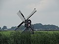 Kramersmolen, Wirdum.JPG 4,608 × 3,456; 3.44 MB
-
 Spinnekopmolens - Wirdum - 20215565 - RCE.jpg 1,200 × 1,179; 217 KB
-
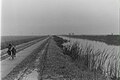 Swettepaad.jpg 3,900 × 2,600; 1.62 MB


