Category:Kreuzweg (Kürnach)
Jump to navigation
Jump to search
| Object location | | View all coordinates using: OpenStreetMap |
|---|
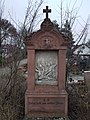
This is the category of the Bavarian Baudenkmal (cultural heritage monument) with the ID D-6-79-156-5 (Wikidata)
|
Deutsch: Kreuzweg, 15 Stationen, figürliche Relieftafeln mit gesprengtem Segmentbogenaufsatz und Kreuzbekrönung über Sockel mit Inschrift, Sandstein, bez. 1885. Friedhofstraße 7; Nähe Flurstraße, im Friedhof, Kürnach, Unterfranken, Deutschland
Media in category "Kreuzweg (Kürnach)"
The following 61 files are in this category, out of 61 total.
-
 00 Vorab-Station Kreuzweg im Friedhof (Kürnach).jpg 2,736 × 3,648; 2.89 MB
-
 01 Station Kreuzweg im Friedhof (Kürnach).jpg 2,736 × 3,648; 3.11 MB
-
 02 Station Kreuzweg im Friedhof (Kürnach).jpg 2,736 × 3,648; 2.67 MB
-
 03 Station Kreuzweg im Friedhof (Kürnach).jpg 2,736 × 3,648; 2.81 MB
-
 04 Station Kreuzweg im Friedhof (Kürnach).jpg 2,736 × 3,648; 2.63 MB
-
 05 Station Kreuzweg im Friedhof (Kürnach).jpg 2,736 × 3,648; 2.77 MB
-
 06 Station Kreuzweg im Friedhof (Kürnach).jpg 2,736 × 3,648; 2.68 MB
-
 07 Station Kreuzweg im Friedhof (Kürnach).jpg 2,736 × 3,648; 4.25 MB
-
 08 Station Kreuzweg im Friedhof (Kürnach).jpg 2,736 × 3,648; 4.22 MB
-
 09 Station Kreuzweg im Friedhof (Kürnach).jpg 2,736 × 3,648; 5.99 MB
-
 10 Station Kreuzweg im Friedhof (Kürnach).jpg 2,736 × 3,648; 5.61 MB
-
 11 Station Kreuzweg im Friedhof (Kürnach).jpg 2,736 × 3,648; 4.7 MB
-
 12 Station Kreuzweg im Friedhof (Kürnach).jpg 2,736 × 3,648; 5.22 MB
-
 13 Station Kreuzweg im Friedhof (Kürnach).jpg 2,736 × 3,648; 5.29 MB
-
 14 Station Kreuzweg im Friedhof (Kürnach).jpg 2,736 × 3,648; 4.91 MB
-
 2017-12-25 Rundgang Kürnach Baudenkmäler Teil 2 - 11.jpg 4,032 × 3,024; 4.72 MB
-
 2017-12-25 Rundgang Kürnach Baudenkmäler Teil 3 Kreuzweg Station - 0.jpg 3,024 × 4,032; 3.76 MB
-
 2017-12-25 Rundgang Kürnach Baudenkmäler Teil 3 Kreuzweg Station - 1.jpg 3,024 × 4,032; 3.35 MB
-
 2017-12-25 Rundgang Kürnach Baudenkmäler Teil 3 Kreuzweg Station - 10.jpg 3,024 × 4,032; 4.06 MB
-
 2017-12-25 Rundgang Kürnach Baudenkmäler Teil 3 Kreuzweg Station - 11.jpg 3,024 × 4,032; 4.12 MB
-
 2017-12-25 Rundgang Kürnach Baudenkmäler Teil 3 Kreuzweg Station - 12.jpg 3,024 × 4,032; 4.3 MB
-
 2017-12-25 Rundgang Kürnach Baudenkmäler Teil 3 Kreuzweg Station - 13.jpg 3,024 × 4,032; 4.05 MB
-
 2017-12-25 Rundgang Kürnach Baudenkmäler Teil 3 Kreuzweg Station - 14.jpg 3,024 × 4,032; 3.53 MB
-
 2017-12-25 Rundgang Kürnach Baudenkmäler Teil 3 Kreuzweg Station - 2.jpg 3,024 × 4,032; 3.28 MB
-
 2017-12-25 Rundgang Kürnach Baudenkmäler Teil 3 Kreuzweg Station - 3.jpg 3,024 × 4,032; 3.4 MB
-
 2017-12-25 Rundgang Kürnach Baudenkmäler Teil 3 Kreuzweg Station - 4.jpg 3,024 × 4,032; 3.4 MB
-
 2017-12-25 Rundgang Kürnach Baudenkmäler Teil 3 Kreuzweg Station - 5.jpg 3,024 × 4,032; 3.39 MB
-
 2017-12-25 Rundgang Kürnach Baudenkmäler Teil 3 Kreuzweg Station - 6.jpg 3,024 × 4,032; 3.44 MB
-
 2017-12-25 Rundgang Kürnach Baudenkmäler Teil 3 Kreuzweg Station - 7.jpg 3,024 × 4,032; 3.36 MB
-
 2017-12-25 Rundgang Kürnach Baudenkmäler Teil 3 Kreuzweg Station - 8.jpg 3,024 × 4,032; 3.07 MB
-
 2017-12-25 Rundgang Kürnach Baudenkmäler Teil 3 Kreuzweg Station - 9.jpg 3,024 × 4,032; 4.67 MB
-
 Kürnach, Friedhof, Kreuzweg I. Station-20151025-001.jpg 3,264 × 4,928; 8.62 MB
-
 Kürnach, Friedhof, Kreuzweg I. Station-20151025-002.jpg 3,264 × 4,928; 8.97 MB
-
 Kürnach, Friedhof, Kreuzweg II. Station-20151025-001.jpg 3,264 × 4,928; 8.55 MB
-
 Kürnach, Friedhof, Kreuzweg II. Station-20151025-002.jpg 3,264 × 4,928; 7.68 MB
-
 Kürnach, Friedhof, Kreuzweg III. Station-20151025-001.jpg 3,264 × 4,928; 8.86 MB
-
 Kürnach, Friedhof, Kreuzweg III. Station-20151025-002.jpg 3,264 × 4,928; 8.62 MB
-
 Kürnach, Friedhof, Kreuzweg IV. Station-20151025-001.jpg 3,264 × 4,928; 8.87 MB
-
 Kürnach, Friedhof, Kreuzweg IV. Station-20151025-002.jpg 3,264 × 4,928; 9.02 MB
-
 Kürnach, Friedhof, Kreuzweg IX. Station-20151025-001-2.jpg 3,264 × 4,928; 11.04 MB
-
 Kürnach, Friedhof, Kreuzweg IX. Station-20151025-001.jpg 3,264 × 4,928; 12.09 MB
-
 Kürnach, Friedhof, Kreuzweg IX. Station-20151025-002-2.jpg 3,264 × 4,928; 9.95 MB
-
 Kürnach, Friedhof, Kreuzweg IX. Station-20151025-002.jpg 3,264 × 4,928; 8.87 MB
-
 Kürnach, Friedhof, Kreuzweg V. Station-20151025-001.jpg 3,264 × 4,928; 9.59 MB
-
 Kürnach, Friedhof, Kreuzweg V. Station-20151025-002.jpg 3,264 × 4,928; 9.25 MB
-
 Kürnach, Friedhof, Kreuzweg VI. Station-20151025-001.jpg 3,264 × 4,928; 8.95 MB
-
 Kürnach, Friedhof, Kreuzweg VI. Station-20151025-002.jpg 3,264 × 4,928; 8.45 MB
-
 Kürnach, Friedhof, Kreuzweg VII. Station-20151025-001.jpg 3,264 × 4,928; 9.45 MB
-
 Kürnach, Friedhof, Kreuzweg VII. Station-20151025-002.jpg 3,264 × 4,928; 8.87 MB
-
 Kürnach, Friedhof, Kreuzweg VIII. Station-20151025-001.jpg 3,264 × 4,928; 9.25 MB
-
 Kürnach, Friedhof, Kreuzweg VIII. Station-20151025-002.jpg 3,264 × 4,928; 8.72 MB
-
 Kürnach, Friedhof, Kreuzweg X. Station-20151025-001.jpg 3,264 × 4,928; 13.49 MB
-
 Kürnach, Friedhof, Kreuzweg XII. Station-20151025-001.jpg 3,264 × 4,928; 10.94 MB
-
 Kürnach, Friedhof, Kreuzweg XII. Station-20151025-002.jpg 3,264 × 4,928; 9.66 MB
-
 Kürnach, Friedhof, Kreuzweg XIII. Station-20151025-001.jpg 3,264 × 4,928; 10.08 MB
-
 Kürnach, Friedhof, Kreuzweg XIII. Station-20151025-002.jpg 3,264 × 4,928; 9.5 MB
-
 Kürnach, Friedhof, Kreuzweg XIV. Station-20151025-001.jpg 3,264 × 4,928; 8.78 MB
-
 Kürnach, Friedhof, Kreuzweg XIV. Station-20151025-002.jpg 3,264 × 4,928; 9.86 MB
-
 Kürnach, Friedhof, Kreuzweg Ölberg-20151025-001.jpg 3,264 × 4,928; 9.19 MB
-
 Kürnach, Friedhof, Kreuzweg Ölberg-20151025-002.jpg 3,264 × 4,928; 8.45 MB
-
 Kürnach, Friedhof, Kreuzweg Ölberg-20151025-003.jpg 4,928 × 3,264; 10.52 MB
.jpg)
.jpg)
.jpg)
.jpg)
.jpg)
.jpg)
.jpg)
.jpg)
.jpg)
.jpg)
.jpg)
.jpg)
.jpg)
.jpg)
.jpg)


