Category:Kriegerdenkmal am Rabenstein
Jump to navigation
Jump to search
| Object location | | View all coordinates using: OpenStreetMap |
|---|
national heritage site  | |||||
| Upload media | |||||
| Instance of |
| ||||
|---|---|---|---|---|---|
| Location | Bad Homburg vor der Höhe, Hochtaunuskreis, Darmstadt Government Region, Hesse, Germany | ||||
| Heritage designation | |||||
 | |||||
This is the category of the Hessian Kulturdenkmal (cultural monument) with the ID 7826 (Wikidata)
|
Media in category "Kriegerdenkmal am Rabenstein"
The following 5 files are in this category, out of 5 total.
-
 Bad Homburg Rabenstein Kriegerdenkmal 2014-03-28 18.19.33.jpg 3,386 × 4,515; 9.3 MB
-
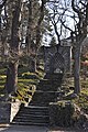 Bad Homburg, Kriegerdenkmal am Rabenstein, Aufgang.JPG 2,848 × 4,288; 6.21 MB
-
 Bad Homburg, Kriegerdenkmal am Rabenstein, Innen.JPG 2,848 × 4,288; 5.19 MB
-
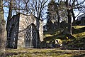 Bad Homburg, Kriegerdenkmal am Rabenstein.JPG 4,288 × 2,848; 6.31 MB
-
 Rabenstein Bad Homburg Gustavstein 2014-03-29 08.54.23 1 WMC.jpg 2,783 × 3,347; 7.88 MB


