Category:Krügerloch
Jump to navigation
Jump to search
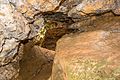
Deutsch: Das Krügerloch (HFA-Katasternummer: K 16) ist Höhle im Doggersandstein im Landkreis Neumarkt in der Oberpfalz in Bayern. Sie ist als Geotop (373H003) und Naturdenkmal ausgewiesen.
Geotop in Landkreis Neumarkt i.d.OPf. in Bavaria, Germany  | |||||
| Upload media | |||||
| Instance of |
| ||||
|---|---|---|---|---|---|
| Part of | |||||
| Location | Berching, Neumarkt, Upper Palatinate, Bavaria, Germany | ||||
| Heritage designation | |||||
| Width |
| ||||
| Length |
| ||||
| Area |
| ||||
| Elevation above sea level |
| ||||
| official website | |||||
 | |||||
Media in category "Krügerloch"
The following 9 files are in this category, out of 9 total.
-
 2015 Krügerloch 01.jpg 4,936 × 3,291; 6.36 MB
-
 2015 Krügerloch 02.jpg 5,056 × 3,371; 4.01 MB
-
 2015 Krügerloch 03.jpg 5,056 × 3,371; 2.9 MB
-
 2015 Krügerloch 04.jpg 3,371 × 5,056; 3.04 MB
-
 2015 Krügerloch 05.jpg 5,056 × 3,371; 4.25 MB
-
 2015 Krügerloch 06.jpg 5,056 × 3,371; 4.51 MB
-
 2015 Krügerloch 07.jpg 5,056 × 3,371; 4.08 MB
-
 2015 Krügerloch 08.jpg 3,371 × 5,056; 5.61 MB
-
 2015 Krügerloch 09.jpg 5,184 × 3,456; 6.24 MB


Categories:
- Geography of Berching
- Plankstetten
- Geotopes in Landkreis Neumarkt in der Oberpfalz
- Caves of Karstgebiet K
- Protected areas in Naturpark Altmühltal
- FFH-Gebiet Trauf der südlichen Frankenalb
- Schutzzone im Naturpark Altmühltal (Landschaftsschutzgebiet)
- Natural monuments in Landkreis Neumarkt in der Oberpfalz
- Geotopes in Naturpark Altmühltal
- Caves in Naturpark Altmühltal
- Eglasmühle