Category:Kuppenloch (D 27)
Jump to navigation
Jump to search
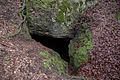
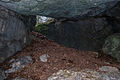
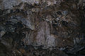
Deutsch: Die Karsthöhle Kuppenloch (HFA-Katasternummer: D 27), auch als Kuppenlochhöhle bezeichnet, befindet sich am Westhang des Kuppenberges im oberfränkischen Landkreis Bayreuth, etwa 1350 Meter nördlich der Ortsmitte der Ortschaft Spies in der Gemeinde Betzenstein im Bundesland Bayern in Deutschland. Die kleine Höhle besteht nur aus einer Halle, und zeigt wenig Sinterschmuck sowie ein Sinterbecken. Sie ist als Naturdenkmal und als Geotop 472R145: "Fels mit Kuppenlochhöhle (D27) N von Spies" geschützt.
This category shows the natural monument in Betzenstein in Bavaria with the ID 04/13 and the name Kuppenlochhöhle.
|
 |
 |
Geotop in Landkreis Bayreuth in Bavaria, Germany _06.jpg) | |||||
| Upload media | |||||
| Instance of | |||||
|---|---|---|---|---|---|
| Location | Betzenstein, Bayreuth, Upper Franconia, Bavaria, Germany | ||||
| Heritage designation | |||||
| Width |
| ||||
| Length |
| ||||
| Area |
| ||||
| Elevation above sea level |
| ||||
| official website | |||||
 | |||||
Media in category "Kuppenloch (D 27)"
The following 12 files are in this category, out of 12 total.
-
 Kuppenloch (D 27) 01.jpg 5,472 × 3,648; 17.09 MB
-
 Kuppenloch (D 27) 02.jpg 5,472 × 3,648; 14.38 MB
-
 Kuppenloch (D 27) 03.jpg 5,472 × 3,648; 14.45 MB
-
 Kuppenloch (D 27) 04.jpg 5,472 × 3,648; 12.88 MB
-
 Kuppenloch (D 27) 05.jpg 5,472 × 3,648; 13.06 MB
-
 Kuppenloch (D 27) 06.jpg 5,472 × 3,648; 14.37 MB
-
 Kuppenloch (D 27) 07.jpg 5,472 × 3,648; 13.43 MB
-
 Kuppenloch (D 27) 08.jpg 5,472 × 3,648; 13.58 MB
-
 Kuppenloch (D 27) 09.jpg 5,472 × 3,648; 14.15 MB
-
 Kuppenloch (D 27) 10.jpg 5,472 × 3,648; 13.02 MB
-
 Kuppenloch (D 27) 11.jpg 3,648 × 5,472; 12.66 MB
-
 Kuppenloch (D 27) 12.jpg 3,648 × 5,472; 12.68 MB
_01.jpg)
_02.jpg)
_03.jpg)
_04.jpg)
_05.jpg)
_07.jpg)
_08.jpg)
_09.jpg)
_10.jpg)
_11.jpg)
_12.jpg)
Categories:
- Natural monuments in Landkreis Bayreuth
- Caves of Karstgebiet D
- Caves of Landkreis Bayreuth
- Geography of Betzenstein
- Geotopes in Landkreis Bayreuth
- Landschaftsschutzgebiet Fränkische Schweiz - Veldensteiner Forst im Regierungsbezirk Oberfranken
- Caves in Naturpark Fränkische Schweiz-Veldensteiner Forst
- Protected areas in Naturpark Fränkische Schweiz-Veldensteiner Forst
- Geotopes in Naturpark Fränkische Schweiz-Veldensteiner Forst