Category:Köpperner Straße 101
Jump to navigation
Jump to search
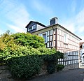
This is the category of the Hessian Kulturdenkmal (cultural monument) with the ID Unknown? (Wikidata)
|
| Object location | | View all coordinates using: OpenStreetMap |
|---|
.JPG) | |||||
| Upload media | |||||
| Instance of | |||||
|---|---|---|---|---|---|
| Location |
| ||||
| Heritage designation | |||||
 | |||||
Media in category "Köpperner Straße 101"
The following 3 files are in this category, out of 3 total.
-
 Köppern, Köpperner Straße 101 (1).JPG 3,096 × 2,360; 3.6 MB
-
 Köppern, Köpperner Straße 101, Seite.jpg 4,939 × 4,785; 17.34 MB
-
 Köppern, Köpperner Straße 101.JPG 4,920 × 3,256; 6.76 MB

