Category:Lütje Hörn
Vai alla navigazione
Vai alla ricerca
Isole Frisone: Ameland · Amrum · Baltrum · Borkum · Engelsmanplaat · Föhr · Griend · Hamburger Hallig · Helgoland · Hooge · Japsand · Juist · Jungnamensand · Kachelotplate · Karkhof · Langeneß · Langeoog · Lütje Hörn · Mellum · Memmert · Minsener Oog · Noorderhaaks · Norderney · Norderoog · Norderoogsand · Nordstrand · Pellworm · Richel · Rif · Rottumeroog · Rottumerplaat · Schiermonnikoog · Simonszand · Spiekeroog · Süderoogsand · Sylt · Terschelling · Texel · Trischen · Vlieland · Wangerooge · Zuiderduintjes ·
isola tedesca   | |||||
| Carica un file multimediale | |||||
| Istanza di |
| ||||
|---|---|---|---|---|---|
| Parte di | |||||
| Area protetta | |||||
| Luogo | Insel Lütje Hörn, circondario di Leer, Bassa Sassonia, Germania | ||||
| Situato sul mare / lago / fiume | |||||
| Popolazione |
| ||||
| Superficie |
| ||||
| Altezza sul mare |
| ||||
 | |||||
Sottocategorie
Questa categoria contiene un'unica sottocategoria, indicata di seguito.
- Aerial photographs of Lütje Hörn (13 F)
File nella categoria "Lütje Hörn"
Questa categoria contiene 4 file, indicati di seguito, su un totale di 4.
-
 Borkum 6.72782E 53.59398N.jpg 1 280 × 958; 87 KB
-
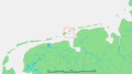
 Lütje Hörn in LER.svg 1 719 × 1 023; 443 KB
-
 Ostfriesische Inseln (Karte).png 13 425 × 5 135; 6,04 MB
-
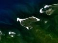
 Wadden - Lutje Horn.png 921 × 512; 29 KB


.png)