Category:LaGrange, New York
Aller à la navigation
Aller à la recherche
town de l'État de New York (États-Unis)  | |||||
| Téléverser des médias | |||||
| Nature de l’élément | |||||
|---|---|---|---|---|---|
| Lieu | comté de Dutchess, New York, É.-U. | ||||
| Population |
| ||||
| Superficie |
| ||||
| Altitude |
| ||||
 | |||||
Media taken in, of or otherwise pertinent to the Town of LaGrange, NY, USA, including the hamlets of LaGrangeville and Freedom Plains.
Sous-catégories
Cette catégorie comprend 2 sous-catégories, dont les 2 ci-dessous.
J
- James Baird State Park (7 F)
T
- Todd Hill Service Area (2 F)
Média dans la catégorie « LaGrange, New York »
Cette catégorie comprend 14 fichiers, dont les 14 ci-dessous.
-
 AHSQuarterMile.jpg 2 304 × 1 728 ; 678 kio
-
 Arlington HS front.jpg 2 304 × 1 728 ; 776 kio
-
 Bales of hay in an open field at sunset.JPG 3 872 × 2 592 ; 3,66 Mio
-
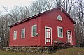
 Beekman Friends Meeting House ruins, LaGrangeville, NY.jpg 2 134 × 1 562 ; 3,38 Mio
-
 Calabi-Picker House.jpeg 3 000 × 2 250 ; 2,58 Mio
-
 Dutchess County New York incorporated areas La Grange highlighted.svg 954 × 766 ; 148 kio
-
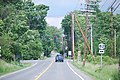 Dutchess CR 21 at NY 82.JPG 3 872 × 2 592 ; 4,64 Mio
-
 Inn at the Falls.jpg 3 888 × 2 592 ; 7,22 Mio
-
 LaGrange District School, Freedom Plains, NY.jpg 3 772 × 2 496 ; 1,06 Mio
-
 LaGrange, NY, town hall.jpg 3 276 × 2 308 ; 3,92 Mio
-
 Lagrange-middle-school-fall07.jpg 1 600 × 1 200 ; 458 kio
-
 Red-oaks-mill-falls.jpg 3 072 × 2 304 ; 1,34 Mio
-
 Taconic State Parkway NB near LaGrangeville, NY.jpg 2 180 × 2 652 ; 5,28 Mio
-
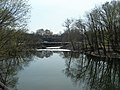
 Wappinger Creek at Red Oaks Mill.jpg 3 072 × 2 304 ; 2,57 Mio


