Category:Labergement-Sainte-Marie - Chapelle Saint-Théodule
Jump to navigation
Jump to search
| Object location | | View all coordinates using: OpenStreetMap |
|---|
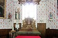
chapel located in Doubs, in France    | |||||
| Upload media | |||||
| Instance of | |||||
|---|---|---|---|---|---|
| Location | Labergement-Sainte-Marie, canton of Mouthe | ||||
 | |||||
Media in category "Labergement-Sainte-Marie - Chapelle Saint-Théodule"
The following 17 files are in this category, out of 17 total.
-
 Chapelle Saint-Théodule - img 36175.jpg 3,630 × 2,420; 3.49 MB
-
 Chapelle Saint-Théodule. (2).jpg 4,000 × 3,000; 4.67 MB
-
 Chapelle Saint-Théodule. (3).jpg 3,000 × 4,000; 2.81 MB
-
 Chapelle saint-Théodule.jpg 3,317 × 2,776; 5.73 MB
-
 Labergement-Sainte-Marie - chapelle Saint-Théodule - intérieur 2.JPG 2,592 × 1,944; 1.9 MB
-
 Labergement-Sainte-Marie - chapelle Saint-Théodule - intérieur.JPG 1,024 × 768; 411 KB
-
 Labergement-Sainte-Marie - chapelle Saint-Théodule 1.JPG 1,024 × 768; 436 KB
-
 Labergement-Sainte-Marie - chapelle Saint-Théodule 2.JPG 2,592 × 1,944; 2.78 MB
-
 Labergement-Sainte-Marie - chapelle Saint-Théodule 3.JPG 2,592 × 1,944; 2.82 MB
-
 Labergement-Sainte-Marie - Chapelle Saint-Théodule.jpg 5,106 × 3,404; 14.91 MB
-
 Labergement-Sainte-Marie. Chapelle Saint Théodule. (2). 2014-03-28.jpg 4,000 × 3,000; 5.13 MB
-
 Saint-Théodule - img 44397.jpg 4,995 × 3,600; 11.08 MB
-
 Saint-Théodule - img 44398.jpg 3,294 × 4,850; 13.23 MB
-
 Saint-Théodule - img 44399.jpg 5,085 × 3,388; 12.32 MB
-
 Saint-Théodule - img 44400.jpg 4,953 × 3,312; 11.53 MB
-
 Saint-Théodule - img 44401.jpg 5,280 × 3,512; 19.53 MB
-
 Saint-Théodule - img 44402.jpg 2,154 × 4,800; 9.7 MB
.jpg)
.jpg)


._2014-03-28.jpg)


