Category:Landkreis Uecker-Randow
Przejdź do nawigacji
Przejdź do wyszukiwania
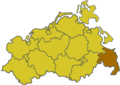
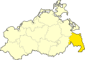
Deutsch: Der ehemalige Landkreis Uecker-Randow liegt im äußersten Südosten von Mecklenburg-Vorpommern an der Grenze zu Polen und am Stettiner Haff.
English: The former Landkreis Uecker-Randow was a district (Landkreis) in the outher south-east of Mecklenburg-Western Pomerania at the boundary to the Republic of Poland and in the west of the Szczecin Lagoon.
former rural district of Germany   | |||||
| Prześlij plik multimedialny | |||||
| Jest to | |||||
|---|---|---|---|---|---|
| Miejsce | Meklemburgia-Pomorze Przednie, Niemcy | ||||
| Stolica | |||||
| Język urzędowy | |||||
| Data utworzenia lub powstania |
| ||||
| Data rozwiązania lub końca |
| ||||
| Liczba ludności |
| ||||
| Powierzchnia |
| ||||
| Zastąpił |
| ||||
| Zastąpiono przez | |||||
 | |||||
Podkategorie
Poniżej wyświetlono 2 spośród wszystkich 2 podkategorii tej kategorii.
U
- Uecker-Randow Bus (4 pliki)
Pliki w kategorii „Landkreis Uecker-Randow”
Poniżej wyświetlono 22 spośród wszystkich 22 plików w tej kategorii.
-
 DEU Landkreis Uecker-Randow COA.svg 512 × 598; 83 KB
-
 Wappen Landkreis Uecker-Randow.png 500 × 566; 183 KB
-
 Anteil der sozialvers. Beschäftigten UER.jpg 2128 × 2571; 1,2 MB
-
 Arbeitslosenquote Uecker-Randow.png 1714 × 1357; 39 KB
-
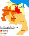
 Bevölkerungsentwicklung Uecker Randow 1990-2002.jpg 2140 × 2607; 1,2 MB
-
 Bevölkerungsentwicklung Uecker Randow 1990-2002.pdf 1062 × 1297; 164 KB
-
 Bevölkerungsentwicklung Uecker-Randow 1990 - 2007.png 2481 × 1753; 77 KB
-
 Bevölkerungsentwicklung Uecker-Randow.png 2235 × 1499; 139 KB
-

-
 Bevölkerungsgewinn- bzw. verlust 2002 bis 2007.png 2154 × 2154; 144 KB
-
 Entwicklung der Beschäftigten in UER.png 2493 × 2958; 196 KB
-
 Entwicklung der Beschäftigten in UER.svg 677 × 792; 101 KB
-
 Gewerbesteueraufkommen 2000 bis 2002 UER.jpg 2122 × 2571; 1,17 MB
-
 Gästeübernachtungen und angebotene Betten im Landkreis Uecker randow.png 1891 × 1241; 59 KB
-
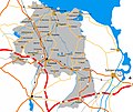 Infrastruktur Uecker Randow.jpg 3068 × 2571; 1,8 MB
-
 Lage des Landkreises Uecker-Randow in Deutschland.png 176 × 234; 5 KB
-
 Locator map UER in Germany.svg 1075 × 1273; 519 KB
-
 Locator map UER in Mecklenburg-Vorpommern.svg 1129 × 775; 260 KB
-
 Mecklenburg wp uer.png 280 × 199; 11 KB
-
 Mecklenburg-Vorpommern UER.svg 1129 × 775; 472 KB
-
 Uecker-Randow, Germany - panoramio.jpg 3072 × 2304; 3,44 MB
-
 UER in Mecklenburg-Vorpommern.svg 859 × 607; 84 KB


