Category:Landsat
Перейти до навігації
Перейти до пошуку
American network of Earth-observing satellites for international research purposes  | |||||
| Завантажити медіафайл | |||||
| Є одним із | |||||
|---|---|---|---|---|---|
| Складники | |||||
| |||||
Підкатегорії
Показано 12 підкатегорій із 12.
1
- Landsat 1 (10 F)
2
3
- Landsat 3 (5 F)
4
- Landsat 4 (4 F)
5
- 50th anniversary of Landsat (4 F)
6
- Landsat 6 (2 F)
7
8
9
I
T
- Valerie L. Thomas (6 F)
Файли в категорії «Landsat»
Показано 19 файлів цієї категорії (із 19).
-
 ERT - LANDSAT SATELLITE AND LAKE MICHIGAN - NARA - 17426523.jpg 6217 × 4846; 26,46 МБ
-
 ERT - LANDSAT SATELLITE AND LAKE MICHIGAN - NARA - 17426525.jpg 6199 × 4846; 28,52 МБ
-
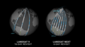
 L8and9-to-LandsatNext-BandComparison.png 2000 × 1546; 249 КБ
-
 Land Sat satellite at the Asteroid Grand Challenge anniversary event 2015.jpg 4746 × 3159; 7,04 МБ
-
Landsat 2023- A Year in Review (SVS14526).webm 6хв 18с, 1920×1080; 49,98 МБ
-
Landsat 40th.ogv 7хв 26с, 640×360; 85,94 МБ
-
 Landsat Missionen.jpg 900 × 216; 99 КБ
-
 Landsat Next Defined (SVS14379 - LNext Blueprint Thumb).png 3186 × 1760; 7,58 МБ
-
 Landsat Next Defined (SVS14379 - LNext Orbits Thumb).png 3396 × 1882; 4,19 МБ
-
 Landsat Next Defined (SVS14379 - LNext Quad Thumb).png 3436 × 1928; 9,51 МБ
-
 Landsat Next Defined (SVS14379 - LNext Spectral Thumb).png 3434 × 1918; 7,36 МБ
-
Landsat Next Defined (SVS14379 - NASA LNext Final).webm 10хв 57с, 1920×1080; 86,69 МБ
-
 Landsat program timeline.png 3200 × 1282; 781 КБ
-
 Landsat-program-timeline-in-2021.jpg 1334 × 628; 180 КБ
-
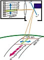 Multispektralabtaster02.jpg 300 × 410; 84 КБ
-
NASA ARSET- Deriving NDVI from Landsat, Part 2-4 (elPbB8k2Sxg).webm 53хв 15с, 1280×720; 133,84 МБ
-
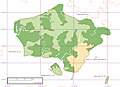 Pepel Island - Marplot Map With PGS Shorelines (1-30,000).jpg 1240 × 904; 316 КБ
-
 Remotesensing-11-01502-v2.pdf 1239 × 1752, 23 сторінки; 5,23 МБ
-
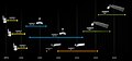
 The spectral band placement for each sensor of Landsat.jpg 1199 × 531; 221 КБ


.png)
.png)
.png)
.png)


.jpg)
