Category:Lange Bisschopstraat 35, Deventer
Jump to navigation
Jump to search
| Object location | | View all coordinates using: OpenStreetMap |
|---|
building in Deventer, Netherlands  | |||||
| Upload media | |||||
| Instance of | |||||
|---|---|---|---|---|---|
| Location | Deventer, Overijssel, Netherlands | ||||
| Street address |
| ||||
| Located on street | |||||
| Heritage designation |
| ||||
 | |||||
|
This is a category about rijksmonument number 12661
|
| Address |
|
Media in category "Lange Bisschopstraat 35, Deventer"
The following 6 files are in this category, out of 6 total.
-
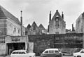 Achteraanzicht - Deventer - 20055513 - RCE.jpg 1,200 × 813; 192 KB
-
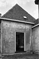
 Achtergevel - Deventer - 20055514 - RCE.jpg 808 × 1,200; 220 KB
-
 Exterieur ACHTERGEVEL NAAST NUMMER 33 - Deventer - 20293911 - RCE.jpg 788 × 1,200; 181 KB
-
 Exterieur ACHTERGEVEL RECHTS VAN NUMMER 33 - Deventer - 20293910 - RCE.jpg 1,195 × 1,200; 300 KB
-
 Lange Bisschopstraat 35 Deventer.jpg 1,712 × 2,560; 889 KB
-
 Voorgevel - Deventer - 20055515 - RCE.jpg 814 × 1,200; 189 KB


