Category:Lange Voorhout 9, The Hague
Jump to navigation
Jump to search
| Object location | | View all coordinates using: OpenStreetMap |
|---|
building in The Hague, Netherlands  | |||||
| Upload media | |||||
| Instance of | |||||
|---|---|---|---|---|---|
| Location | The Hague, South Holland, Netherlands | ||||
| Located on street |
| ||||
| Heritage designation |
| ||||
 | |||||
|
This is a category about rijksmonument number 17677
|
| Address |
|
Media in category "Lange Voorhout 9, The Hague"
The following 11 files are in this category, out of 11 total.
-
 Den Haag - Lange Voorhout 9.JPG 2,736 × 3,648; 4.81 MB
-
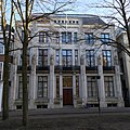 Lange Voorhout 9, The Hague.jpg 3,024 × 3,024; 3.47 MB
-
 Plafond - 's-Gravenhage - 20091026 - RCE.jpg 1,200 × 847; 159 KB
-
 Plafond - 's-Gravenhage - 20091029 - RCE.jpg 1,200 × 875; 145 KB
-
 Plafond - 's-Gravenhage - 20091030 - RCE.jpg 1,200 × 865; 143 KB
-
 Plafonds - 's-Gravenhage - 20091027 - RCE.jpg 1,200 × 787; 187 KB
-
 Plafonds - 's-Gravenhage - 20091028 - RCE.jpg 1,200 × 848; 113 KB
-
 Uitgeverij Martinus Nijhoff - Martinus Nijhoff Publishers (4751573476).jpg 931 × 1,280; 233 KB
-
 Voorgevel - 's-Gravenhage - 20091032 - RCE.jpg 953 × 1,200; 243 KB
-
 Voorgevel - 's-Gravenhage - 20091033 - RCE.jpg 950 × 1,200; 245 KB
-
 Voorgevels - 's-Gravenhage - 20091034 - RCE.jpg 1,200 × 952; 272 KB


.jpg)


