Category:Langkofel group
Zur Navigation springen
Zur Suche springen
Gebirgsgruppe der Dolomiten  | |||||
| Medium hochladen | |||||
| Ist ein(e) | |||||
|---|---|---|---|---|---|
| Ort |
| ||||
| Gebirgszug | |||||
| Höchster Punkt | |||||
| Höhe über dem Meeresspiegel |
| ||||
 | |||||
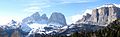
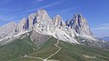
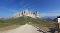
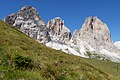
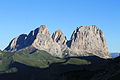
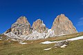
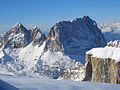
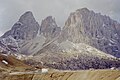
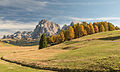
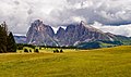
Deutsch: Die Langkofelgruppe ist ein Bergmassiv der Dolomiten in Trentino-Südtirol.
English: The Langkofel group is a massif of the Dolomites in Trentino-South Tyrol.
Italiano: Il Gruppo del Sassolungo è un massico delle Dolomiti, Sudtirolo, Trentino
Unterkategorien
Es werden 14 von insgesamt 14 Unterkategorien in dieser Kategorie angezeigt:
In Klammern die Anzahl der enthaltenen Kategorien (K), Seiten (S), Dateien (D)
E
- Emilio-Comici-Hütte (3 D)
F
- Fünffingerspitze (21 D)
G
- Grohmannspitze (1 S, 23 D)
I
- Innerkoflerturm (10 D)
L
- Langkofelhütte (33 D)
P
- Plattkofelhütte (7 D)
R
- Rifugio Friedrich August (7 D)
- Rifugio Sandro Pertini (4 D)
S
- Sellajochhaus (3 D)
T
- Toni-Demetz-Hütte (5 D)
Z
- Zahnkofel (1 S, 11 D)
Seiten in der Kategorie „Langkofel group“
Diese Kategorie enthält nur die folgende Seite.
Medien in der Kategorie „Langkofel group“
Folgende 200 Dateien sind in dieser Kategorie, von 351 insgesamt.
(vorherige Seite) (nächste Seite)-
 070406-10 Langkofel.jpg 3.072 × 2.304; 3,08 MB
-
 070406-10 Sellajoch.jpg 6.174 × 1.920; 1,87 MB
-
 11 Langkofel group, Dolomites, Italy.jpg 1.024 × 768; 204 KB
-
 2315-Duron-N.jpg 3.376 × 5.064; 9,36 MB
-
 2315-Duron-SW.jpg 1.744 × 2.616; 2,72 MB
-
 2340-Latzfons-SO.jpg 6.000 × 3.376; 8,82 MB
-
 39040 Kastelruth, Province of Bolzano - South Tyrol, Italy - panoramio (87).jpg 3.072 × 1.728; 3,12 MB
-
 39040 Kastelruth, Province of Bolzano - South Tyrol, Italy - panoramio (88).jpg 3.072 × 1.728; 3,07 MB
-
 39040 Kastelruth, Province of Bolzano - South Tyrol, Italy - panoramio (89).jpg 3.072 × 1.728; 2,89 MB
-
 39040 Kastelruth, Province of Bolzano - South Tyrol, Italy - panoramio (90).jpg 3.072 × 1.728; 2,79 MB
-
 A108433-Pano-1.jpg 13.564 × 3.161; 13,39 MB
-
 A108448-Pano-1.jpg 15.102 × 3.151; 16,29 MB
-
 Abendliches Bergpanorama von der Klausner Hütte.jpg 5.472 × 2.912; 1,66 MB
-
 Alba rosè - panoramio.jpg 4.000 × 3.000; 2,51 MB
-
 Alpe di Siusi banner Panorama.jpg 2.100 × 300; 833 KB
-
 AlpediSiusi panorama2.JPG 10.528 × 1.568; 6,06 MB
-
 Altipiano Sciliar.jpg 1.181 × 886; 124 KB
-
 Anonimo.Dolomiti, Panorama Col Sassolungo? RA50.jpg 1.024 × 733; 147 KB
-
 Anton Hlavacek Langkofel mit Fünffinger Spitze und Grohmannspitze vom Sellajoch.jpg 2.322 × 1.704; 774 KB
-
 St. Peter Lajen J. Arnold d.j. 1845.jpg 3.657 × 2.542; 5,14 MB
-
 Astfeld-046.JPG 3.888 × 2.222; 688 KB
-
 Autumn on the meadows of Seiser Alm with Saslong.jpg 5.000 × 3.021; 8,44 MB
-
 Autunno in quota,ogni stagione ha la sua grande bellezza - panoramio.jpg 4.000 × 3.000; 2,44 MB
-
 Baita tarassaco & Dolomiti.jpg 3.024 × 4.032; 4,07 MB
-
 Blick in das Tal zwischen Plattkofel und Langkofel - panoramio.jpg 2.048 × 1.536; 1,2 MB
-
 Blick vom piz Boe 2019-09-03 8.jpg 3.648 × 2.736; 4,24 MB
-
 Bolzano-Tirol del Sur 1995 16.jpg 1.065 × 707; 641 KB
-
 Bujes de Ciaulonch troi per Dantersasc.jpg 4.912 × 7.360; 30,05 MB
-
 Bujes de Ciaulonch.jpg 7.208 × 4.648; 20,18 MB
-
 CampitelloFassa.JPG 3.072 × 2.304; 1,17 MB
-
 Canazei - Passo Sella, Italy - panoramio.jpg 3.008 × 2.000; 2,63 MB
-
 Canazei, Province of Trento, Italy - panoramio (10).jpg 4.922 × 2.765; 5,19 MB
-
 Canazei, Province of Trento, Italy - panoramio (13).jpg 4.712 × 2.660; 4,66 MB
-
 Canazei, Province of Trento, Italy - panoramio (3).jpg 2.592 × 1.944; 1,27 MB
-
 Canazei, Province of Trento, Italy - panoramio (33).jpg 3.264 × 2.448; 2,2 MB
-
 Canazei, Province of Trento, Italy - panoramio (5).jpg 2.592 × 1.944; 1,26 MB
-
 Canazei, Province of Trento, Italy - panoramio (7).jpg 2.592 × 1.944; 1,29 MB
-
 Capela dl Pas Sela cun Saslonch.jpg 15.086 × 12.172; 79,34 MB
-
 Cherta Sela Saslonch DÖAV Freytag Berndt 1904.jpg 8.272 × 6.200; 38,47 MB
-
 Church St. Jakob Urtijei.jpg 4.288 × 2.848; 6,85 MB
-
 Ciajea Cason sun Resciesa Urtijëi.jpg 18.905 × 9.069; 118,36 MB
-
 Ciandevaves y Mont de Pana cun Saslonch Sela y Cir.jpg 17.893 × 8.082; 72,38 MB
-
 Cime Spettacolari - panoramio.jpg 2.304 × 1.728; 962 KB
-
 Col da Mesdi Saslonch Gherdëina.jpg 15.960 × 6.623; 81,02 MB
-
 Col Rodella.jpg 8.444 × 3.918; 5,13 MB
-

-
 Costa de Sot pert sun streda Urtijëi.jpg 8.272 × 6.200; 44,21 MB
-
 Crepuscolo sul Sassolungo - nov2012 - panoramio.jpg 2.560 × 1.920; 1,91 MB
-
 Dal Corno del Renon (BZ) panorama sulle Dolomiti - panoramio (1).jpg 3.264 × 2.448; 2,31 MB
-
 Dal Sass-Pordoi ....Magnifico paesagggio - panoramio.jpg 2.048 × 1.533; 391 KB
-
 Dalla Regina ,vista dolomitica - panoramio.jpg 4.000 × 3.000; 2,58 MB
-
 Dantersasc Saslonch.JPG 4.288 × 2.848; 7,15 MB
-
 Dark and gloomy atmosphere at Alpe di Siusi in italian Dolomites.jpg 6.630 × 3.996; 5,12 MB
-
 Der Weg zur Friedrich-August Hütte in der Abendsonne - panoramio.jpg 2.048 × 1.536; 1,37 MB
-
 Diagonale nel cuore - panoramio.jpg 4.000 × 3.000; 2,38 MB
-
 Die Friedrich-August Hütte (ca. 2300m) - panoramio.jpg 2.048 × 1.536; 1,42 MB
-
 Dlieja da Sacun cun Saslonch-edit.jpg 6.000 × 4.004; 19,97 MB
-
 Dlieja da Sacun cun Saslonch.jpg 6.000 × 4.004; 11,28 MB
-
 Dolomiten - Seiser Alm - Puflatschhütte - 02-2007 - panoramio.jpg 1.600 × 1.200; 424 KB
-
 Dolomiten - Sella mit Langkofel und Plattkofel - 02-2007 - panoramio.jpg 1.600 × 1.200; 427 KB
-
 Dolomiten1974 44 hg.jpg 5.405 × 3.506; 3,45 MB
-
 Dolomiten1974 45 hg.jpg 5.358 × 3.434; 15,89 MB
-
 Dolomiti Alpe Siusi - panoramio.jpg 3.978 × 2.641; 1,69 MB
-
 Duron-S-Pano.jpg 12.416 × 1.856; 9,7 MB
-
 Erratischer Dolomit-Block Cionstoan Seiseralm 2017 2.jpg 7.360 × 4.912; 15,77 MB
-
 Etappe 3 - Aussicht vom Walter-Brenninger-Biwak.jpg 4.896 × 3.672; 3,08 MB
-
 Fassa valley.jpg 5.582 × 4.032; 3,1 MB
-
 Ferrata Schuster - panoramio (1).jpg 4.000 × 2.664; 4,35 MB
-
 Fischbachl Seiseralm Südtirol.JPG 7.360 × 4.912; 15,74 MB
-
 Foto concorso alpi 7.jpg 5.994 × 3.749; 11,52 MB
-
 Friedrich-August-Hütte.jpg 3.862 × 1.572; 1,7 MB
-
 Fuenffinger.jpg 3.072 × 2.304; 3,06 MB
-
 Georg Janny - Langkofelgruppe seen from the Pordoijoch.jpg 5.741 × 4.494; 4,89 MB
-
 Gherdeina da Stevia Silvester.jpg 12.000 × 4.417; 22,55 MB
-
 Giaurida dla sosta dl Jëuf dl Sela.jpg 5.106 × 3.949; 20,84 MB
-
 Giro Sassopiatto - Sassolungo 01.jpg 4.128 × 2.322; 3,5 MB
-
 Giro Sassopiatto - Sassolungo 02.jpg 2.560 × 1.440; 1,14 MB
-
 Giro Sassopiatto - Sassolungo 04.jpg 2.322 × 4.128; 4,33 MB
-
 Giro Sassopiatto - Sassolungo 05.jpg 4.128 × 2.322; 4,38 MB
-
 Giro Sassopiatto - Sassolungo 06.jpg 2.560 × 1.440; 1,41 MB
-
 Giro Sassopiatto - Sassolungo 07.jpg 4.128 × 2.322; 4,28 MB
-
 Giro Sassopiatto - Sassolungo 08.jpg 2.322 × 4.128; 4,94 MB
-
 Giro Sassopiatto - Sassolungo 09.jpg 4.128 × 2.322; 4,2 MB
-
 Giro Sassopiatto - Sassolungo 10.jpg 4.128 × 2.322; 4,1 MB
-
 Giro Sassopiatto - Sassolungo 11.jpg 2.322 × 4.128; 4,8 MB
-
 Giro Sassopiatto - Sassolungo 12.jpg 2.560 × 1.440; 1,16 MB
-
 Giro Sassopiatto - Sassolungo 13.jpg 4.128 × 2.322; 3,49 MB
-
 Giro Sassopiatto - Sassolungo 14.jpg 2.560 × 1.440; 1,23 MB
-
 Giro Sassopiatto - Sassolungo 15.jpg 4.128 × 2.322; 3,6 MB
-
 Groednerjoch westrampe langkofel.jpg 1.944 × 1.296; 888 KB
-
 Grohmann und Fünffinger.jpg 7.360 × 4.912; 17,71 MB
-
 Gruppo del Sassolungo 20200817 n02.jpg 8.305 × 4.671; 17,23 MB
-
 Gruppo del Sassolungo 20200819 n01.jpg 8.256 × 5.504; 14,87 MB
-
 Gruppo del Sassolungo dal Passo Pordoi.jpeg 4.272 × 2.848; 3,8 MB
-
 Grödner Dolomiten Seiser-Alm Hi res.jpg 15.468 × 4.163; 24,76 MB
-
 Il Gruppo del Sassolungo.jpg 4.752 × 3.168; 6,76 MB
-
 Il Gruppo delle Odle da Velturno (BZ) - panoramio.jpg 2.560 × 1.920; 395 KB
-
 Il sasso lungo dalla marmolada - panoramio.jpg 4.000 × 3.000; 4,19 MB
-
 Image schilliar wiki.jpg 4.992 × 2.368; 1,26 MB
-
 It-Punta Grohmann, de-Grohmannspitze.jpg 2.048 × 1.536; 641 KB
-
 Italien - Lang- und Plattkofel von der Seiser Alm aus - panoramio.jpg 1.600 × 1.200; 915 KB
-
 Italy Ortisei panorama.JPG 1.600 × 1.200; 712 KB
-
 Karte der Langkofel und Sellagruppe DÖAV.jpg 8.272 × 6.200; 35,7 MB
-
 Kastelruth vom Ritten.jpg 3.264 × 2.448; 1,15 MB
-
 Konrad Petrides Langkofelgruppe.jpg 3.486 × 2.508; 4,59 MB
-
 La città dei sassi.jpg 5.088 × 1.760; 3,05 MB
-
 La maestosita' del Sasso lungo e del Sasso piatto - val Gardena.jpg 4.032 × 3.024; 2,38 MB
-
 La Marmolada dal Sasso Piatto - panoramio.jpg 4.000 × 3.000; 2,47 MB
-
 Lagekarte der Langkofelgruppe.png 4.311 × 5.006; 5,52 MB
-
 Lang- und Plattkofel mit Wolken - panoramio.jpg 1.600 × 1.200; 410 KB
-
 Lang- und Plattkofel.jpg 3.264 × 1.836; 1,19 MB
-
 Langkofel - Puez - Sella - 01.jpg 13.129 × 3.851; 29,45 MB
-
 Langkofel - Puez - Sella - 02.jpg 16.535 × 4.685; 51,4 MB
-
 Langkofel Gipfelregion.jpg 3.070 × 574; 846 KB
-
 Langkofel Group 01.jpg 4.752 × 3.168; 11,53 MB
-
 Langkofel Group 02.jpg 11.595 × 3.953; 24,99 MB
-
 Langkofel Group 03.jpg 4.080 × 3.168; 9,08 MB
-
 Langkofel Group from Sellajoch 2012.jpg 7.360 × 4.912; 18,31 MB
-
 Langkofel group from Sellajoch Col Rodella Fassa.jpg 10.500 × 9.423; 95,19 MB
-
 Langkofel Group from Sellajoch Fassa.jpg 7.360 × 4.912; 17,66 MB
-
 Langkofel group from Sellajoch Fassa.jpg 13.000 × 7.945; 97,77 MB
-
 Langkofel group from Sellajoch Gherdëina.jpg 13.393 × 5.175; 58,3 MB
-
 Langkofel Group from Sellajoch.jpg 4.288 × 2.848; 6,2 MB
-
 Langkofel group from the Sella pass 2016.jpg 7.171 × 4.912; 15,91 MB
-
 Langkofel Group S.JPG 3.759 × 1.692; 4,5 MB
-
 Langkofel Gruppe 2019-09-03.jpg 3.648 × 2.736; 3,58 MB
-
 Langkofel Sassolungo Saslonch aus St. Peter.jpg 2.304 × 3.072; 4,63 MB
-
 Langkofel scharte.jpg 1.280 × 960; 377 KB
-
 Langkofel Schlern über Seis.jpg 9.000 × 4.012; 24,89 MB
-
 Langkofel stchristina.jpg 1.280 × 960; 253 KB
-
 Langkofel und Plattkofel..jpg 3.772 × 2.077; 1,06 MB
-
 Langkofel und Plattkofel.jpg 5.184 × 2.963; 5,02 MB
-
 Langkofel-im-Winter 0604 a.jpg 2.560 × 1.920; 2,28 MB
-
 Langkofelgruppe 1.JPG 2.592 × 1.944; 2,77 MB
-
 Langkofelgruppe Blick vom Ritten Oktober 2004.jpg 1.600 × 1.200; 703 KB
-
 Langkofelgruppe E v Sellajoch 300 PICT0183 199005tt.jpg 2.520 × 1.680; 1.008 KB
-
 Langkofelgruppe from the sky.jpg 1.902 × 1.513; 605 KB
-
 Langkofelgruppe nach Bergalbum.png 4.311 × 5.006; 5,52 MB
-
 Langkofelgruppe-von-Osten 4433.jpg 3.264 × 2.448; 4,22 MB
-
 Langkofelgruppe.jpg 1.024 × 768; 637 KB
-
 Langkofelgruppe.JPG 3.648 × 2.048; 2,48 MB
-
 Langkofelis.JPG 1.638 × 625; 313 KB
-
 Langkokfel e Plattkofel.jpg 6.016 × 4.016; 10,53 MB
-
 Latzfons Aussicht auf die Dolomiten (2 05-2015).jpg 5.472 × 3.648; 4,31 MB
-
 Lech de Mont de Pana Cëndevaves.jpg 15.047 × 9.458; 97,97 MB
-
 Lech dl Mandl sun Mastle cun Saslonch y Sella.jpg 6.500 × 4.338; 8,56 MB
-
 Leresc y pec sa Sacun cun Saslonch Gherdeina.jpg 7.360 × 4.912; 25,14 MB
-
 Leresc y pec sa Sacun Gherdeina.jpg 7.360 × 4.912; 22,92 MB
-
 Maria Matilda Ogilvie Gordon Langkofelgruppe.jpg 1.000 × 498; 104 KB
-
 Marmolada, cime.jpg 4.592 × 3.056; 4,03 MB
-
 Marmolada, Dolomites (agost 2013) - panoramio (1).jpg 3.648 × 2.736; 3,7 MB
-
 Marmolada, Pordoi.jpg 4.592 × 3.056; 4,03 MB
-
 Max Sparer Seiseralm mit Langkofel Holzschnitt.jpg 3.505 × 4.483; 9,11 MB
-
 Mont dal Ega.jpg 7.360 × 4.912; 19,63 MB
-
 Mont de Seuc Fabian 2012 017 01.JPG 7.360 × 4.912; 16,49 MB
-
 Mont de Seuc y l Saslong auton.jpg 7.360 × 4.912; 21,12 MB
-
 Mont de Seuc y l Saslong da Cod dal Fil.jpg 7.360 × 3.504; 14,67 MB
-
 Mont de Seuc y l Saslong da Col de Mezdi.jpg 6.986 × 3.750; 14,22 MB
-
 Mont de Seuc y l Saslong Edit.jpg 5.000 × 3.000; 6,97 MB
-
 Mont de Seuc y l Saslong.jpg 5.000 × 3.002; 9,62 MB
-
 Mont de Sëuc cun paluc Col dal Fil.jpg 33.282 × 8.860; 167,31 MB
-
 Mont de Sëuc cun palusc y saslong auton.jpg 6.624 × 4.142; 15,34 MB
-
 Mont de Sëuc cun Saslonch y nibles.jpg 10.000 × 5.916; 53,02 MB
-
 Mont de Sëuc Saslonch y lëns de leresc pudejé.jpg 10.584 × 5.625; 35,07 MB
-
 Mont de Sëuc Saslonch y lëns de leresc.jpg 8.272 × 6.200; 43,44 MB
-
 Mont de Sëuc Seiser Alm Montes de Gherdëina purtoies da pudejé.jpg 13.017 × 4.654; 28,3 MB
-
 Mont de Sëuc Seiser Alm Montes de Gherdëina.jpg 11.835 × 5.724; 37,16 MB
-
 Mont de Sëuc y crëpes de Gherdëina.jpg 14.500 × 7.681; 95,45 MB
-
 Mont de Sëuc y la Dolomites de Gherdëina dinviërn.jpg 13.693 × 6.195; 54,66 MB
-
 Mont de Sëuc y Saslonch cun leresc.jpg 6.500 × 4.338; 15,92 MB
-
 Monte Pana, Blick auf Langkofel - panoramio.jpg 3.920 × 2.204; 1,99 MB
-
 Monte pana3.jpg 1.280 × 960; 149 KB
-
 Notte in tenda a Punta Rocca 3250 m. Con Sambo.jpg 4.032 × 2.268; 3,16 MB
-
 Odles Seceda Pic Sela Saslonch da Resciesa Gherdëina.jpg 14.491 × 3.715; 27,72 MB
-
 Odles Seceda Saslonch da Resciesa dedite.jpg 17.476 × 6.278; 58,3 MB
-
 Odles Secëda Saslonch da Resciesa dedite Gherdëina.jpg 17.476 × 6.278; 58,67 MB
-
 Old hotel Pordoi.jpg 3.269 × 2.097; 2,32 MB
-
 P8120049-3.jpg 4.608 × 1.892; 2,8 MB
-
 P8120071-Edit-2-2.jpg 4.199 × 3.377; 5,46 MB
-
 Padded (252577089).jpeg 2.048 × 1.536; 278 KB
-
 PANO 20170312 131112.jpg 7.430 × 1.872; 2,68 MB
-
 PANO 20170804 100744.jpg 5.928 × 2.696; 2,96 MB
-
 Panorama dalla ferrata Schuster - panoramio.jpg 4.000 × 3.000; 2,54 MB
-
 Panorama from Belvedere Dolomites.jpg 15.444 × 4.461; 42,6 MB
-
 Paolo Monti - Serie fotografica - BEIC 6363580.jpg 1.244 × 1.280; 1,99 MB
-
 Paraglider tauchen auf - panoramio.jpg 2.048 × 1.536; 1.005 KB
-
 Pardell Villanders Dolomitenblick.jpg 3.768 × 5.340; 13,79 MB
-
 Partenza del giro al sasso lungo - panoramio.jpg 2.816 × 2.112; 1,5 MB
-
 Passo Pordoi 2007.jpg 1.815 × 1.093; 1,67 MB
-

-
 Passo Sella - panoramio.jpg 3.008 × 2.000; 1,45 MB
-
 Passo sella langkofelgruppe.jpg 1.944 × 1.296; 910 KB
-
 Passo sella on the path.jpg 3.888 × 2.592; 779 KB
-
 PassoSella0002.jpg 500 × 374; 59 KB
-
 Pastura te Ncisles Pieralongia cun Saslong.jpg 6.500 × 4.338; 16,48 MB
-
 Pietro De Grandi 2017 (Unsplash).jpg 6.000 × 3.375; 17,7 MB
-
 Platt- und Langkofel.jpg 3.115 × 1.896; 711 KB
-
 Plattkofel 1.JPG 6.000 × 4.000; 6,06 MB
-
 Plattkofel 2.JPG 6.000 × 4.000; 6,02 MB
-
 Plattkofel 3.JPG 6.000 × 4.000; 4,74 MB


.jpg)
.jpg)
.jpg)
.jpg)


.jpg)
.jpg)
.jpg)
.jpg)
.jpg)
.jpg)


_panorama_sulle_Dolomiti_-_panoramio_(1).jpg)


_-_panoramio.jpg)


.jpg)


_-_panoramio.jpg)


.jpg)


_-_panoramio_(1).jpg)


.jpeg)


_-_panoramio.jpg)


.jpg)


