Category:Laxton, East Riding of Yorkshire
Jump to navigation
Jump to search
Main Wikipedia article: Laxton, East Riding of Yorkshire.
a village located in East Riding of Yorkshire, United Kingdom  | |||||
| Upload media | |||||
| Instance of | |||||
|---|---|---|---|---|---|
| Location | East Riding of Yorkshire, Yorkshire and the Humber, England | ||||
 | |||||
Subcategories
This category has the following 6 subcategories, out of 6 total.
Media in category "Laxton, East Riding of Yorkshire"
The following 200 files are in this category, out of 298 total.
(previous page) (next page)-
 "The Bricklayers Arms" in Laxton - geograph.org.uk - 3132635.jpg 4,142 × 2,959; 2.54 MB
-
 A Field Of Northside Farm - geograph.org.uk - 256243.jpg 640 × 480; 105 KB
-
 A house on Trandy Lane, Laxton - geograph.org.uk - 859233.jpg 640 × 480; 242 KB
-
 A minor road to Yokefleet - geograph.org.uk - 2209017.jpg 800 × 600; 186 KB
-
 A nice house in Laxton - geograph.org.uk - 858671.jpg 640 × 508; 210 KB
-
 A Public Bridleway - geograph.org.uk - 248035.jpg 640 × 480; 107 KB
-
 A Public Bridleway - geograph.org.uk - 248037.jpg 640 × 480; 99 KB
-
 A sea of wheat - geograph.org.uk - 6219776.jpg 1,024 × 768; 218 KB
-
 A sliver of land - geograph.org.uk - 3700884.jpg 1,024 × 768; 119 KB
-
 Access road from High Metham along Celery Bank - geograph.org.uk - 6188764.jpg 4,608 × 3,456; 4.07 MB
-
 Access road from Low Metham Grange - geograph.org.uk - 6186416.jpg 4,608 × 3,456; 5 MB
-
 Access track to Carr House Farm - geograph.org.uk - 6188769.jpg 4,608 × 3,456; 4.01 MB
-
 Across September stubble to Low Metham Grange - geograph.org.uk - 3133061.jpg 4,425 × 2,950; 2.56 MB
-
 Alongside Eastrington Drain - geograph.org.uk - 3671717.jpg 1,024 × 768; 216 KB
-
 Back Street, Laxton - geograph.org.uk - 5051866.jpg 1,200 × 799; 303 KB
-
 Balkholm Crossing - geograph.org.uk - 3715285.jpg 1,024 × 768; 142 KB
-
 Balkholme Crossing - geograph.org.uk - 1366427.jpg 640 × 480; 84 KB
-
 Bank House - geograph.org.uk - 6202016.jpg 640 × 480; 100 KB
-
 Bank House from Trans Pennine Trail - geograph.org.uk - 6188847.jpg 4,608 × 3,456; 4.09 MB
-
 Barn at Sowby's Farm, Saltmarshe - geograph.org.uk - 3671742.jpg 1,024 × 768; 233 KB
-
 Beacon on the north bank of the River Ouse - geograph.org.uk - 3570973.jpg 1,024 × 768; 104 KB
-
 Bricklayers Arms, Laxton - geograph.org.uk - 1333602.jpg 640 × 480; 81 KB
-
 Bridleway to Cotness - geograph.org.uk - 3671724.jpg 1,024 × 768; 236 KB
-
 Bridleway towards Cotness Hall - geograph.org.uk - 2023694.jpg 640 × 480; 82 KB
-
 Carr House Farm - geograph.org.uk - 256247.jpg 640 × 480; 102 KB
-
 Carr House Farm, Celery Bank - geograph.org.uk - 5051687.jpg 1,200 × 799; 399 KB
-
 Carr Lane near Laxton - geograph.org.uk - 3715347.jpg 1,024 × 768; 158 KB
-
 Celery Bank - geograph.org.uk - 3671698.jpg 1,024 × 768; 228 KB
-
 Celery Bank - geograph.org.uk - 3715374.jpg 1,024 × 768; 120 KB
-
 Celery Bank at Carr House Farm - geograph.org.uk - 5051692.jpg 1,200 × 799; 372 KB
-
 Celery Bank towards Carr Lane - geograph.org.uk - 5051706.jpg 1,200 × 799; 403 KB
-
 Church of St Peter - geograph.org.uk - 5442697.jpg 800 × 600; 159 KB
-
 Cleaned out drain alongside West Plantation - geograph.org.uk - 6188856.jpg 4,608 × 3,456; 4.97 MB
-
 Corner Bays on Trandy Lane, Laxton - geograph.org.uk - 5052107.jpg 1,200 × 799; 341 KB
-
 Cotness Bridge - geograph.org.uk - 5764951.jpg 1,024 × 768; 340 KB
-
 Cotness Bridge - geograph.org.uk - 5764955.jpg 1,024 × 768; 345 KB
-
 Cotness Drain at Cotness Clough - geograph.org.uk - 5585614.jpg 5,376 × 3,024; 2.59 MB
-
 Cotness Drain south toward River Ouse - geograph.org.uk - 1873589.jpg 4,000 × 3,000; 3.25 MB
-
 Cotness Hall - geograph.org.uk - 1873567.jpg 4,000 × 3,000; 3.79 MB
-
 Cotness Lane, near Saltmarshe - geograph.org.uk - 5263587.jpg 640 × 480; 141 KB
-
 Cotness Roads and Trans-Pennine Trail - geograph.org.uk - 6020418.jpg 1,024 × 768; 138 KB
-
 Cottage and Newclose Plantation - geograph.org.uk - 3700972.jpg 1,024 × 768; 161 KB
-
 Cottage by the railway - geograph.org.uk - 3701684.jpg 1,024 × 768; 149 KB
-
 Cultivated field and dividing hedge - geograph.org.uk - 5838802.jpg 4,000 × 3,000; 3.51 MB
-
 Day Hills Plantation - geograph.org.uk - 1254703.jpg 640 × 480; 118 KB
-
 Drain beside Greenoak Lane - geograph.org.uk - 1603702.jpg 640 × 480; 79 KB
-
 Drainage off Metham Lane - geograph.org.uk - 2023727.jpg 640 × 480; 97 KB
-
 Driveway to Saltmarshe Hall - geograph.org.uk - 5441896.jpg 800 × 600; 121 KB
-
 East along Main Street, Saltmarshe - geograph.org.uk - 2290333.jpg 800 × 600; 222 KB
-
 Eems Sky passing Saltmarshe - geograph.org.uk - 3701981.jpg 1,024 × 768; 139 KB
-
 Entering Laxton, East Yorkshire - geograph.org.uk - 2209102.jpg 800 × 600; 264 KB
-
 Ewes by the Ouse looking towards Dairy Farm - geograph.org.uk - 5585868.jpg 5,376 × 3,024; 2.61 MB
-

-
 Farmland between Kilpin and Laxton - geograph.org.uk - 3132625.jpg 4,608 × 3,072; 3.48 MB
-
 Farmland near Greenoak - geograph.org.uk - 2023556.jpg 640 × 480; 19 KB
-
 Farmland near Laxton - geograph.org.uk - 2023713.jpg 640 × 480; 66 KB
-
 Farmland near Metham Hall - geograph.org.uk - 2023729.jpg 640 × 480; 90 KB
-
 Farmland near Northside Farm - geograph.org.uk - 2023558.jpg 640 × 436; 22 KB
-
 Farmland near Saltmarshe - geograph.org.uk - 4260393.jpg 640 × 419; 201 KB
-
 Farmland off Metham Lane - geograph.org.uk - 2023720.jpg 640 × 480; 99 KB
-
 Farmland, Saltmarshe - geograph.org.uk - 2023675.jpg 640 × 480; 55 KB
-
 Farmland, Saltmarshe Park - geograph.org.uk - 2023663.jpg 640 × 480; 71 KB
-
 Field And Wolds - geograph.org.uk - 256235.jpg 640 × 480; 100 KB
-
 Field edge north of Cotness - geograph.org.uk - 3671686.jpg 1,024 × 768; 179 KB
-
 Field south-east of Skelton - geograph.org.uk - 2288330.jpg 1,500 × 945; 1.15 MB
-
 Field-edge footpath to Yokefleet - geograph.org.uk - 5838799.jpg 4,000 × 3,000; 3.48 MB
-
 Fields by Low Meatham - geograph.org.uk - 6020345.jpg 1,024 × 768; 183 KB
-
 Fields near Metham Hall - geograph.org.uk - 5263588.jpg 523 × 640; 153 KB
-
 Fields off Chapel Lane - geograph.org.uk - 1366428.jpg 640 × 480; 95 KB
-
 Fields to Northside Farm - geograph.org.uk - 1366425.jpg 640 × 480; 63 KB
-
 Fingerpost pointing to nowhere - geograph.org.uk - 5050510.jpg 1,200 × 799; 625 KB
-
 Flat fields near Laxton - geograph.org.uk - 6020359.jpg 1,024 × 768; 216 KB
-
 Footbridge over Eastrington Drain - geograph.org.uk - 3715352.jpg 1,024 × 768; 257 KB
-
 Footpath towards Carr House Farm - geograph.org.uk - 6219770.jpg 1,024 × 768; 144 KB
-
 Fox Lane from Saltmarshe to Laxton - geograph.org.uk - 1876471.jpg 4,000 × 3,000; 2.79 MB
-
 Fox Lane, Saltmarshe - geograph.org.uk - 635721.jpg 640 × 419; 34 KB
-
 Front Street in Laxton - geograph.org.uk - 3132641.jpg 4,608 × 3,072; 3.51 MB
-
 Front Street, Laxton - geograph.org.uk - 2023710.jpg 640 × 480; 85 KB
-
 Front Street, Laxton - geograph.org.uk - 5263586.jpg 640 × 498; 129 KB
-
 Front Street, Laxton - geograph.org.uk - 6020356.jpg 1,024 × 768; 141 KB
-
 Gates at Warping Clough - geograph.org.uk - 3671775.jpg 1,024 × 768; 205 KB
-
 Greenoak Lane Level crossing - geograph.org.uk - 1365234.jpg 640 × 480; 54 KB
-
 Heading to Goole at high tide - geograph.org.uk - 2016435.jpg 1,024 × 768; 107 KB
-
 Heading towards Carr House Farm - geograph.org.uk - 5050689.jpg 1,200 × 799; 445 KB
-
 Heading towards Carr House Farm - geograph.org.uk - 5050697.jpg 1,200 × 799; 393 KB
-
 Heading towards Carr House Farm - geograph.org.uk - 5050707.jpg 1,200 × 799; 458 KB
-
 Heading towards Carr House Farm - geograph.org.uk - 5050709.jpg 1,200 × 799; 438 KB
-
 Heading towards Carr House Farm - geograph.org.uk - 5050713.jpg 1,200 × 799; 451 KB
-
 Heading towards Carr House Farm - geograph.org.uk - 5050720.jpg 1,200 × 799; 429 KB
-
 Heading towards Carr Lane - geograph.org.uk - 5051726.jpg 1,200 × 799; 500 KB
-
 Heading towards West Plantation - geograph.org.uk - 3700964.jpg 1,024 × 768; 182 KB
-
 High Metham - geograph.org.uk - 3715370.jpg 1,024 × 768; 150 KB
-
 High Metham, Celery Bank - geograph.org.uk - 5051682.jpg 1,200 × 799; 463 KB
-
 Houses off Jubilee Avenue, Laxton - geograph.org.uk - 5051863.jpg 1,200 × 799; 405 KB
-
 Houses on Back Street, Laxton - geograph.org.uk - 5051871.jpg 1,200 × 799; 389 KB
-
 Houses on Back Street, Laxton - geograph.org.uk - 5051874.jpg 1,200 × 799; 442 KB
-
 Houses on Back Street, Laxton - geograph.org.uk - 5051879.jpg 1,200 × 799; 404 KB
-
 Houses on Back Street, Laxton - geograph.org.uk - 5052078.jpg 1,200 × 799; 372 KB
-
 Houses on Main Street, Saltmarshe - geograph.org.uk - 5585825.jpg 5,376 × 3,024; 2.68 MB
-
 Humber Renown, east of Saltmarshe Hall - geograph.org.uk - 3597931.jpg 1,024 × 614; 113 KB
-
 Irrigation pond - geograph.org.uk - 3700982.jpg 1,024 × 768; 162 KB
-
 Jubilee Avenue, Laxton - geograph.org.uk - 5051857.jpg 1,200 × 799; 461 KB
-
 Lane going south toward Yokefleet - geograph.org.uk - 6188780.jpg 4,608 × 3,456; 4.53 MB
-
 Lane linking Moorfields Lane with Skelton Broad Lane - geograph.org.uk - 5838780.jpg 4,000 × 3,000; 4.47 MB
-
 Lane to Kilpin - geograph.org.uk - 1526397.jpg 502 × 640; 173 KB
-
 Lane to Waterside House and Metham Clough - geograph.org.uk - 5838800.jpg 4,000 × 3,000; 3.37 MB
-
 Large wheatfield at Cotness Clough - geograph.org.uk - 5442601.jpg 800 × 600; 115 KB
-
 Laxton Drain - geograph.org.uk - 2023682.jpg 640 × 480; 105 KB
-
 Laxton Drain east of Laxton - geograph.org.uk - 5051733.jpg 1,200 × 799; 522 KB
-
 Laxton Garage - geograph.org.uk - 1333547.jpg 640 × 480; 81 KB
-
 Laxton Garage - geograph.org.uk - 2023707.jpg 640 × 480; 87 KB
-
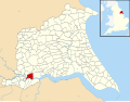 Laxton, East Riding of Yorkshire UK parish locator map.svg 1,425 × 1,107; 1.68 MB
-
 Laxton, East Riding of Yorkshire.jpg 2,524 × 2,557; 877 KB
-
 Laxton.jpg 640 × 480; 155 KB
-
 Little Reedness across the River Ouse - geograph.org.uk - 1873603.jpg 4,000 × 3,000; 2.93 MB
-

-

-
 Looking towards Bank House Farm - geograph.org.uk - 3700970.jpg 1,024 × 768; 222 KB
-
 Low Meatham Cottages entrance - geograph.org.uk - 6020350.jpg 1,024 × 768; 160 KB
-
 Low Metham Cottages - geograph.org.uk - 5050503.jpg 1,200 × 799; 442 KB
-
 Low Metham Cottages - geograph.org.uk - 5050504.jpg 1,200 × 799; 376 KB
-
 Low Metham Grange - geograph.org.uk - 5050505.jpg 1,200 × 799; 495 KB
-
 Magnolia House on Back Street, Laxton - geograph.org.uk - 5052081.jpg 1,200 × 799; 416 KB
-
 Main Street, Laxton - geograph.org.uk - 1333576.jpg 640 × 480; 70 KB
-
 Main Street, Saltmarshe - geograph.org.uk - 2290310.jpg 800 × 600; 216 KB
-
 Main Street, Saltmarshe - geograph.org.uk - 2290321.jpg 800 × 600; 218 KB
-
 Main Street, Saltmarshe - geograph.org.uk - 4223881.jpg 640 × 480; 114 KB
-
 Main Street, Saltmarshe - geograph.org.uk - 5610700.jpg 3,751 × 4,922; 4.89 MB
-
 Main Street, Saltmarshe - geograph.org.uk - 6020428.jpg 1,024 × 768; 129 KB
-
 Making repairs - geograph.org.uk - 3673029.jpg 1,024 × 768; 109 KB
-
 Manor Farm - geograph.org.uk - 5442706.jpg 800 × 600; 138 KB
-
 Manor House Farm on Trandy Lane, Laxton - geograph.org.uk - 5052099.jpg 1,200 × 799; 359 KB
-
 Manor House Farm on Trandy Lane, Laxton - geograph.org.uk - 5052104.jpg 1,200 × 799; 508 KB
-
 Manor House on Trandy Lane, Laxton - geograph.org.uk - 5052101.jpg 1,200 × 799; 423 KB
-
 Memorial near Saltmarshe - geograph.org.uk - 6020429.jpg 1,024 × 768; 314 KB
-

-
 Metham Lane - geograph.org.uk - 5442699.jpg 800 × 600; 198 KB
-
 Metham Lane - geograph.org.uk - 5442703.jpg 800 × 600; 132 KB
-
 Metham Lane heading east - geograph.org.uk - 2023724.jpg 640 × 480; 88 KB
-
 Metham Lane heading toward Laxton - geograph.org.uk - 6189502.jpg 4,440 × 3,220; 4.52 MB
-
 Metham Lane heading towards Laxton - geograph.org.uk - 5838793.jpg 4,000 × 3,000; 3.92 MB
-
 Metham Lane heading towards Metham Hall Farm - geograph.org.uk - 5838796.jpg 4,000 × 3,000; 3.56 MB
-
 Metham Lane toward Laxton - geograph.org.uk - 6189496.jpg 4,608 × 3,456; 4.06 MB
-
 Metham Lane towards Cotness Lane - geograph.org.uk - 2209097.jpg 800 × 600; 207 KB
-
 Mill Lane, Saltmarshe - geograph.org.uk - 2023678.jpg 640 × 480; 70 KB
-
 Minor road between Metham and Greenoak - geograph.org.uk - 5441888.jpg 800 × 600; 121 KB
-
 Minor road towards Saltmarshe - geograph.org.uk - 2023664.jpg 640 × 480; 63 KB
-
 Moorfields Lane entering Saltmarshe - geograph.org.uk - 5838782.jpg 4,000 × 3,000; 3.42 MB
-
 MS Pluto at Saltmarshe - geograph.org.uk - 3701993.jpg 1,024 × 768; 136 KB
-
 MS Pluto passing Saltmarshe - geograph.org.uk - 3700845.jpg 1,024 × 768; 119 KB
-
 Navigation aid by the River Ouse at Saltmarshe Hall Staith - geograph.org.uk - 5585848.jpg 5,376 × 3,024; 2.06 MB
-
 Navigation beacon 21, east of Bank House - geograph.org.uk - 3585330.jpg 1,024 × 768; 182 KB
-
 Navigation beacon on the River Ouse - geograph.org.uk - 3671792.jpg 1,024 × 768; 126 KB
-
 Navigation beacon west of Laxton Clough - geograph.org.uk - 3585388.jpg 1,024 × 768; 104 KB
-
 Navigation beacon, Groves Staith, River Ouse - geograph.org.uk - 3585366.jpg 1,024 × 768; 99 KB
-
 Navigation beacons at Bank House - geograph.org.uk - 3585323.jpg 1,024 × 615; 103 KB
-
 Navigation marker beside the River Ouse - geograph.org.uk - 6202014.jpg 480 × 640; 100 KB
-

-
 Near Drain - geograph.org.uk - 6020362.jpg 1,024 × 768; 331 KB
-
 New lake near Laxton - geograph.org.uk - 3715196.jpg 1,024 × 768; 122 KB
-
 New Lane approaching Laxcton - geograph.org.uk - 5838785.jpg 4,000 × 3,000; 2.82 MB
-
 North bank of the Ouse at Cotness Roads - geograph.org.uk - 3585379.jpg 1,024 × 768; 111 KB
-
 North bank of the Ouse, at Saltmarshe Hall - geograph.org.uk - 3585342.jpg 1,024 × 768; 144 KB
-
 North bank of the Ouse, near Bank House - geograph.org.uk - 3570977.jpg 1,024 × 768; 68 KB
-
 North bank of the River Ouse - geograph.org.uk - 3585404.jpg 1,024 × 614; 63 KB
-
 North to Kilpin, East Yorkshire - geograph.org.uk - 2290063.jpg 800 × 600; 265 KB
-
 Northside Lane heading north - geograph.org.uk - 2023714.jpg 640 × 480; 64 KB
-
 Old signal box at Saltmarshe railway station - geograph.org.uk - 3132630.jpg 3,063 × 4,288; 2.95 MB
-
 On Fox Lane looking north to Laxton - geograph.org.uk - 5610707.jpg 4,807 × 3,378; 4.81 MB
-
 On the levee looking towards Saltmarshe - geograph.org.uk - 5585801.jpg 5,376 × 3,024; 2.79 MB
-
 Ordnance Survey Cut Mark - geograph.org.uk - 5839637.jpg 4,000 × 3,000; 3.53 MB
-
 Owl box and the Ouse flood bank - geograph.org.uk - 3673115.jpg 1,024 × 768; 128 KB
-
 Paradise Farm - geograph.org.uk - 3700974.jpg 1,024 × 768; 156 KB
-
 Path by Saltmarshe Hall - geograph.org.uk - 6020415.jpg 1,024 × 768; 315 KB
-
 Path leading to Carr Lane and Laxton - geograph.org.uk - 5051713.jpg 1,200 × 799; 422 KB
-
 Path leading to Carr Lane and Laxton - geograph.org.uk - 5051718.jpg 1,200 × 799; 366 KB
-
 Path leading to Low Metham Grange - geograph.org.uk - 5050500.jpg 1,200 × 799; 484 KB
-

-
 Permissive bridleway (2) - geograph.org.uk - 3701010.jpg 1,024 × 768; 177 KB
-
 Permissive bridleway - geograph.org.uk - 3700997.jpg 1,024 × 768; 137 KB
-
 Permissive bridleway - geograph.org.uk - 3701002.jpg 1,024 × 768; 200 KB
-
 Plank Bridge, near Yokefleet - geograph.org.uk - 5263592.jpg 640 × 480; 188 KB
-
 Plantation in a flat landscape - geograph.org.uk - 3715357.jpg 1,024 × 768; 96 KB
-
 Plenty of grazing here - geograph.org.uk - 6020409.jpg 1,024 × 768; 179 KB
-
 Pond at Low Metham Grange - geograph.org.uk - 6186425.jpg 4,608 × 3,456; 6.9 MB
-
 Public Right of Way towards Carr House Farm - geograph.org.uk - 5050679.jpg 1,200 × 799; 388 KB
-
 River Ouse at Reedness - geograph.org.uk - 2210492.jpg 2,000 × 1,500; 2.94 MB
-
 River Ouse from the Flood Bank - geograph.org.uk - 1876452.jpg 4,000 × 3,000; 2.31 MB
-
 River Ouse levee at Saltmarshe - geograph.org.uk - 5585809.jpg 5,376 × 3,024; 2.51 MB
-
 River Ouse navigation marker - geograph.org.uk - 5610685.jpg 4,861 × 3,396; 3.18 MB
-
 River Ouse near Bank House - geograph.org.uk - 6020410.jpg 1,024 × 768; 103 KB
-
 River Ouse near Saltmarshe - geograph.org.uk - 6020421.jpg 1,024 × 768; 162 KB
-
 Riverside building, north bank, River Ouse - geograph.org.uk - 3622655.jpg 1,024 × 768; 157 KB
-
 RMS Duisburg in Whitgift Roads - geograph.org.uk - 2016420.jpg 1,024 × 768; 122 KB
-
 RMS Tharsis - geograph.org.uk - 6203056.jpg 4,608 × 3,072; 2.63 MB
-
 Road to High Meatham - geograph.org.uk - 6020354.jpg 1,024 × 768; 257 KB
-
 Road to Metham Hall - geograph.org.uk - 6127774.jpg 1,024 × 768; 162 KB
-
 Saltmarshe Hall - geograph.org.uk - 2023666.jpg 640 × 480; 71 KB
-
 Saltmarshe Hall - geograph.org.uk - 3700894.jpg 1,024 × 768; 223 KB
-
 Saltmarshe Hall - geograph.org.uk - 3701050.jpg 1,024 × 768; 157 KB


_near_Saltmarshe_Hall_-_geograph.org.uk_-_2023671.jpg)


_-_geograph.org.uk_-_3701010.jpg)


