Category:Lechquellengebirge
Zur Navigation springen
Zur Suche springen
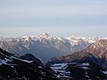
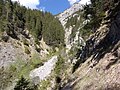
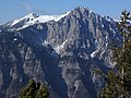
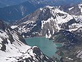
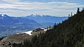
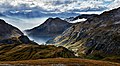
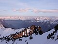
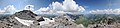
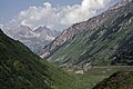
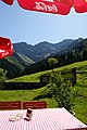
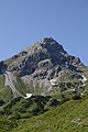
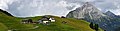
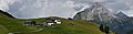
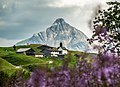
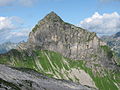
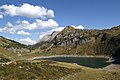
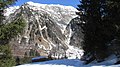
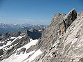
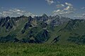
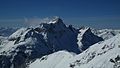
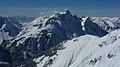
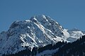
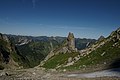
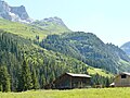
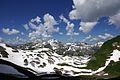
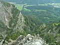
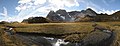
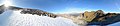
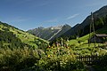
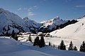
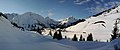
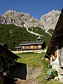
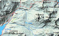
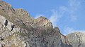
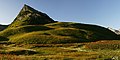
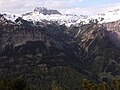
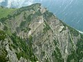
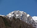
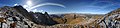
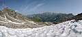
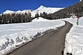
Deutsch: Das Lechquellengebirge ist eine Gebirgsgruppe der Nördlichen Kalkalpen in den Ostalpen. Das Gebirge befindet sich vollumfänglich im österreichischen Bundesland Vorarlberg.
Gebirgsgruppe der Alpen   | |||||
| Medium hochladen | |||||
| Ist ein(e) | |||||
|---|---|---|---|---|---|
| Material | |||||
| Ort | Vorarlberg, Österreich | ||||
| Gebirgszug | |||||
| Höchster Punkt | |||||
| Höhe über dem Meeresspiegel |
| ||||
 | |||||
Unterkategorien
Es werden 24 von insgesamt 24 Unterkategorien in dieser Kategorie angezeigt:
In Klammern die Anzahl der enthaltenen Kategorien (K), Seiten (S), Dateien (D)
A
- Alpsee (Dalaas) (5 D)
D
- Disnerbergalpe (7 D)
F
- Formaletsch (8 D)
- Formarinalpe (13 D)
- Formarinsee (47 D)
G
- Gadenalpe (3 D)
- Gipslöcher Oberlech (14 D)
K
- Klostertaler Bergwälder (2 D)
M
- Matonaalpe (13 D)
S
- Saloberkopf (8 D)
- Schadonapass (8 D)
- Steinernes Meer (Vorarlberg) (20 D)
T
- Thomas Praßler Weg (3 D)
W
- Weimarer Steig (10 D)
Z
- Zürsersee (26 D)
Medien in der Kategorie „Lechquellengebirge“
Folgende 177 Dateien sind in dieser Kategorie, von 177 insgesamt.
-
 02 Stierkopf, Burtschakopf links hinter ihm.jpg 3.264 × 1.832; 1,58 MB
-
 03 Braunarl vom Westgipfel, Madlochspitze links davor.jpg 3.648 × 2.736; 1,88 MB
-
 04 Lechquellengebirge.jpg 3.648 × 2.736; 1,89 MB
-
 10 Klostertal mit Roggelskopf, Braz, Verwall.jpg 3.648 × 2.736; 1,13 MB
-

-
 100 0997 Elsalptürme und Elsspitze.jpg 2.592 × 1.944; 786 KB
-
 100 0998 Mittlawaldtobel.jpg 2.592 × 1.944; 873 KB
-
 100 1000 Mittlawaldtobel.jpg 2.592 × 1.944; 886 KB
-
 100 1001 Nüziders aus Bereich Wasserhütte Schwende.jpg 2.592 × 1.944; 967 KB
-
 11 Roggelskopf.jpg 3.648 × 2.736; 1,52 MB
-
 12 Novakopf und Gamsfreiheit.jpg 3.648 × 2.736; 1,77 MB
-
 13 Wildgrube mit Muggengrat-Bergstation.jpg 3.648 × 2.736; 1,71 MB
-
 16 Roggelskopf.jpg 3.648 × 2.736; 1,64 MB
-
 16 Zoom auf See, darüber Plattnitzerjoch- und Glongspitze.jpg 4.608 × 3.456; 6,68 MB
-
 2 Frassenhaus.jpg 4.608 × 2.592; 2,02 MB
-
 2015 Spullersee im Lechquellengebirge.jpg 7.360 × 4.072; 29,04 MB
-
 23 Rote Wand.jpg 3.264 × 1.832; 946 KB
-
 24 Weißes Rößle.jpg 3.648 × 2.736; 1,62 MB
-
 26 Roggalspitze und Große Wildgrubenspitze.jpg 3.264 × 2.448; 2,3 MB
-
 30 Elsspitze.jpg 3.648 × 2.736; 1,41 MB
-
 300° Diedamskopf Panorama.jpg 9.559 × 1.362; 1,89 MB
-
 31 Klösterle mit der S 16.jpg 2.560 × 1.920; 1,68 MB
-
 35 Stierkopf, Hochjoch vom Elsfürkele.jpg 3.648 × 2.736; 1,75 MB
-
 360 Grad Wildgrubenspitzen.jpg 14.000 × 3.185; 26,36 MB
-
 360° Hochkünzelspitze 2397m.jpg 8.950 × 1.728; 3,69 MB
-
 360° Kanisfluh.jpg 8.767 × 1.712; 4,76 MB
-
 360° Mohnenfluh Oberlech Panorama.jpg 7.331 × 2.578; 12,33 MB
-
 360° Mohnenfluh Panorama.jpg 9.023 × 2.119; 11,97 MB
-
 360° Panorama Zitterklapfen 2.jpg 9.642 × 1.856; 4,84 MB
-
 360° Panorama Zitterklapfen.jpg 9.642 × 1.856; 4,89 MB
-
 360° Schadonapaß.jpg 11.061 × 1.582; 5,06 MB
-
 360° Schalzbachvorsäß Panorama 1.jpg 8.525 × 1.812; 9,5 MB
-
 360º Pano Auenfeld Hochtannberg.jpg 21.239 × 4.402; 29,45 MB
-
 40 Mohnenfluh und Juppenspitze.jpg 3.648 × 2.736; 1,72 MB
-
 Alpe Brazer Staffel 1961m vor dem Stierloch Joch, Panorama.jpg 8.472 × 2.094; 16,58 MB
-
 Alpe Spitzegga 1.JPG 4.161 × 2.773; 1,77 MB
-
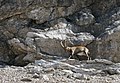 Alpensteinbock Butzenspitze.JPG 2.504 × 1.734; 3,09 MB
-
 An der Abbruchkante des Bratschenkopf im Disnergschröf.JPG 4.800 × 3.200; 9,25 MB
-
 Arlberg - panoramio (2).jpg 1.152 × 864; 527 KB
-
 Arlbergbahn talauswärts.jpg 4.608 × 2.592; 2,73 MB
-
 Au Holand Panorama.jpg 5.978 × 2.487; 1,48 MB
-
 Autriche-Tyrol-Vorarlberg -19920804.jpg 3.104 × 2.072; 2,05 MB
-
 Bahnhof Braz vom Hinterbirgweg.jpg 2.592 × 1.944; 1,1 MB
-
 Berbigenvorsäß 1.JPG 3.008 × 2.000; 1,53 MB
-
 Berbigenvorsäß 2.JPG 3.008 × 2.000; 1,41 MB
-
 Bergkristall Bodenvorsäß 2.JPG 4.272 × 2.848; 9,6 MB
-
 Bergkristall Bodenvorsäß 3.JPG 2.848 × 4.272; 8,2 MB
-
 Bettlerspitze 2272m Nordseite.JPG 3.200 × 4.800; 8,21 MB
-
 Bettlerspitze 2272m.JPG 4.272 × 2.848; 2,79 MB
-

-
 Blick vom Nordalpenweg auf die SO Bergkette.jpg 8.386 × 3.858; 10,98 MB
-
 Braz mit EC 164.jpg 3.648 × 2.736; 1,62 MB
-
 Bregenzerwaldgebirge Panorama.jpg 6.219 × 2.137; 1,55 MB
-
 Breithorn vom Rappaschrofaweg.jpg 2.592 × 1.944; 1,19 MB
-
 Breithorn, Elsalptürme, Elsspitze und Elsfürkele von Furklastraße.jpg 2.592 × 1.944; 855 KB
-
 Butzenspitze 2547m Panorama.jpg 4.729 × 2.328; 2,37 MB
-
 Bürstegg Biberkopf EDIT SK.jpg 8.376 × 2.174; 13,75 MB
-
 Bürstegg Biberkopf.JPG 4.816 × 3.415; 5,01 MB
-
 Bürstegg Biberkopf.jpg 8.376 × 2.174; 3,29 MB
-
 Bürstegg vor Bieberkopf 2020 Böhringer 01.JPG 6.390 × 4.615; 19,9 MB
-
 Bürstegg vor Bieberkopf 2020 Böhringer 02.JPG 5.971 × 4.312; 14,32 MB
-
 Bürstegg vor Bieberkopf 2020 Böhringer 03.JPG 6.441 × 4.652; 16,84 MB
-
 Bürstegg vor Bieberkopf 2020 Böhringer 04.jpg 5.439 × 3.928; 14,77 MB
-

-
 Compton, 1905, Elsspitze and Katzenköpfe von der Furklaalpe.jpg 1.001 × 714; 226 KB
-
 Die Wasserfälle über dem Rosengarten in Braz.jpg 4.608 × 2.592; 4,34 MB
-
 Diedamskopf 1.JPG 4.272 × 2.848; 1,35 MB
-
 Drei Türme unterhalb der Gamsfreiheit.jpg 3.264 × 1.832; 1,86 MB
-
 Dürrenbach Gletscher.jpg 4.017 × 2.396; 4,09 MB
-
 Eisvorhang oberhalb der Verbauungen im Mittlawaldtobel.jpg 3.648 × 2.736; 1,58 MB
-
 Enziane (27259911620).jpg 6.000 × 4.004; 4,56 MB
-
 Evtl. die Nadel 2685 m im Lechquellengebirge.jpg 2.272 × 1.704; 1.002 KB
-
 Faschina Fontanella Panorama.jpg 7.487 × 2.123; 3,32 MB
-
 Faschina Panorama.jpg 7.639 × 2.118; 2,06 MB
-
 Fernblick auf Hochlichtspitze und das Schutzhaus des Göppinger Alpenvereins.jpg 4.608 × 2.592; 2,23 MB
-
 Feuerstein Mountain.JPG 3.456 × 2.592; 4,95 MB
-
 Formarinsee1.JPG 3.008 × 2.000; 2,81 MB
-
 Gadental Großes Walsertal Hanno Thurnher Cinedoku Vorarlberg.jpg 5.661 × 912; 699 KB
-
 Gadner-Disnergschröf Panorama.jpg 8.273 × 2.726; 16,46 MB
-
 Galerie über Innerbraz.jpg 3.264 × 1.832; 2,41 MB
-
 Geislinger, Jäger Steig Panorama Schröcken.jpg 5.310 × 2.973; 3,28 MB
-
 Geislinger, Jäger Steig Panorama.jpg 7.237 × 2.299; 12,46 MB
-
 GletscherbrückeRoteWand 1.JPG 2.848 × 4.272; 7,88 MB
-
 GletscherbrückeRoteWand 2.JPG 2.848 × 4.272; 7,09 MB
-
 Grausames Äußeres Grubser Tobel vom Zacken 1888 m.jpg 4.032 × 3.024; 2,9 MB
-
 Großes Walsertal.jpg 1.278 × 720; 204 KB
-
 Großtobel bei Langen.jpg 4.608 × 2.592; 2,91 MB
-
 Grubser Tobel.jpg 3.648 × 2.736; 1,63 MB
-
 Grünes Gräshorn 2201m Annalper Stecken 2124m.JPG 3.008 × 2.000; 1,49 MB
-
 Göppinger Hütte.jpg 1.203 × 762; 1,12 MB
-
 Göppinger vom Hochlichtaufstieg.jpg 3.072 × 2.304; 1,58 MB
-
 Hahnenkopf Faschina.jpg 2.844 × 1.483; 887 KB
-
 Heilbronner Weg.JPG 3.264 × 2.448; 4,19 MB
-
 Heiterberg vom Baerenkopf.jpg 1.456 × 968; 223 KB
-
 Hills - panoramio (26).jpg 4.000 × 3.000; 3,71 MB
-
 Hl Maria in Schalzbachvorsäß.JPG 2.846 × 2.846; 1,98 MB
-
 Hochkünzelspitze from East.JPG 3.648 × 2.052; 1,63 MB
-
 Hochkünzelspitze from East02.JPG 2.256 × 1.269; 855 KB
-
 Hochkünzelspitze from Northeast.JPG 3.264 × 2.448; 2,63 MB
-
 Hochkünzelspitze from South.JPG 3.152 × 1.773; 1,44 MB
-
 Hochkünzelspitze Niedere Künzelspitze.JPG 4.272 × 2.848; 7,98 MB
-
 Hochlicht und Blasenka.jpg 4.000 × 3.000; 5,91 MB
-
 Hoher Fraßen.JPG 4.000 × 3.000; 2,11 MB
-
 Im Radonatobel. Typisch ist die ständige Erosion.jpg 4.608 × 2.592; 3,33 MB
-
 Jungfernspitze2212m.JPG 4.272 × 2.848; 2,33 MB
-
 Kanisfluh Antony Gormley Horizon Field.JPG 3.648 × 2.736; 2,63 MB
-
 Kar Laguz Alpe Madratsch.JPG 4.272 × 2.848; 2,91 MB
-
 Karsee-1.jpg 640 × 480; 80 KB
-
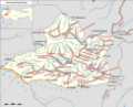 Karte Lechquellengebirge.png 4.167 × 3.372; 2,83 MB
-
 Kessanaschlucht Tafel.jpg 657 × 945; 195 KB
-
 KlesenzaAlpe Bettlerspitze.JPG 2.848 × 4.272; 3,23 MB
-
 Klesenzatal Hutlabach.JPG 4.272 × 2.848; 5,13 MB
-
 Kranzenzian, Gentianella.JPG 1.848 × 2.669; 2,56 MB
-
 KörberseeJuppenspitze.JPG 2.000 × 2.000; 882 KB
-
 Lech, Blick Richtung Südwest, Stierlochkopf - panoramio (3).jpg 3.072 × 2.304; 4,04 MB
-
 Lech-Omesberg-Blick zum Lechquellgebiet (Dalaas).jpg 4.592 × 2.576; 3,97 MB
-
 Lech.Alpy.JPG 2.304 × 1.728; 1,96 MB
-
 Lechquellengebirge-1.jpg 640 × 480; 109 KB
-
 Lechquellengebirge1.jpg 3.872 × 2.592; 5,82 MB
-
 Lechquellengebirge2.JPG 3.438 × 2.292; 4,83 MB
-
 Lechquellengebirge3.jpg 3.872 × 2.592; 6,22 MB
-
 Lechquellengebirge4.JPG 3.872 × 2.592; 3,37 MB
-
 Lechquellengebirge5.jpg 3.872 × 2.592; 6,85 MB
-
 Lechquellengebirge6.JPG 3.872 × 2.592; 2,45 MB
-
 Liaskalk der Roten Wand.jpg 4.608 × 2.592; 3,22 MB
-
 Liaskalk in Nordwestflanke der Roten Wand.jpg 4.608 × 2.592; 3,12 MB
-
 Links Radin rechts Stallehr vom Zacken 1888 m.jpg 4.032 × 3.024; 2,1 MB
-
 Madloch Panorama.jpg 5.504 × 2.103; 11,04 MB
-
 Madloch Zürs Panorama.jpg 8.757 × 3.385; 22,84 MB
-
 Madlochjoch Panorama.jpg 9.766 × 2.153; 15,9 MB
-
 Madratsch2287mSätteli1737m.JPG 4.272 × 2.848; 9,46 MB
-
 Map of Spullersee.JPG 4.320 × 3.240; 8,04 MB
-
 Marul Gamsfreiheit.JPG 4.272 × 2.848; 7,84 MB
-
 Marul von der Gamsfreiheit.jpg 4.608 × 2.592; 3,18 MB
-
 Masonfall von Stallehr.jpg 1.920 × 1.080; 487 KB
-
 Masonweg mit Roggelskopf.jpg 3.264 × 1.832; 2,06 MB
-
 Mindelheimer Huette from Kemptner Kopf.JPG 3.264 × 2.448; 4,21 MB
-
 Misthaufen mountain and Rote Wand glacier.jpg 11.636 × 3.866; 27,01 MB
-
 Misthaufen, Gadnerköpfe, Klesenzhörner, Bettlerspitze.jpg 3.966 × 2.096; 6,9 MB
-
 Mohnenfluhsattel Panorama.jpg 8.649 × 2.054; 13,84 MB
-
 Muttersberg vom Rappaschrofaweg.jpg 4.608 × 2.592; 3,74 MB
-
 Nesslegg Schadona Rothorn Hohe Künzelspitze.JPG 3.008 × 2.000; 2,07 MB
-
 Nesslegg, Schröcken 1.jpg 6.794 × 2.571; 10,33 MB
-
 Nesslegg, Schröcken 2.jpg 4.288 × 2.848; 1,09 MB
-
 Nesslegg, Schröcken 3.jpg 6.126 × 2.572; 9,09 MB
-
 Panorama Karhorn.jpg 25.207 × 2.378; 28,05 MB
-
 Panorama nach Westen vom Formaletsch.jpg 7.292 × 2.150; 11,47 MB
-
 Panorama von der Höferspitze.jpg 21.333 × 2.277; 46,76 MB
-
 Pfarrer Josef Kary 1953.JPG 2.846 × 3.794; 3,79 MB
-
 Raggal Gamsfreiheit.JPG 4.272 × 2.848; 8,67 MB
-
 Ravensburger Hütte, Roggalspitze, Spullersee, Wildgratspitze.jpg 819 × 495; 403 KB
-
 Rote Gesteinsader am Madratsch, Gestein an Bahnhöfen der Arlbergbahn eingebaut.jpg 4.608 × 2.592; 3,5 MB
-
 Rothorn 2239m Biberacher Hütte, Hochkünzelspitze 2397m.jpg 8.433 × 1.737; 4,21 MB
-
 Rothorn 2239m Biberacher Hütte.jpg 6.708 × 2.114; 4,04 MB
-
 Rothorn 2239m from Biberacher Hütte (cropped).jpg 3.986 × 1.983; 2,2 MB
-
 Rothorn Wasserkluppe.JPG 4.272 × 2.848; 6,78 MB
-
 Rundblättrige Glockenblume, Campanula rotundifolia 1.JPG 2.134 × 2.846; 3,1 MB
-
 Salober view.jpg 11.160 × 1.836; 4,96 MB
-
 Schalzbachvorsäß Panorama 2.jpg 6.445 × 1.577; 5,58 MB
-
 Schillernder Mohrenfalter, Erebia tyndarus.JPG 3.541 × 2.361; 4,21 MB
-
 Schmiedetobel.jpg 3.648 × 2.736; 1,48 MB
-
 Schwarzenberg Bersbuch Panorama 1.jpg 5.856 × 2.819; 1,85 MB
-
 Sonderdach 248.JPG 3.008 × 2.000; 1,9 MB
-
 Spullerschafberg, Mehlsack SE.JPG 4.092 × 2.916; 9,66 MB
-
 Stein Fontanella Faschina.JPG 4.272 × 2.848; 7,92 MB
-
 Stierkopf vom Zacken 1888 m, rechts unten Alfenzwerk-Stausee.jpg 4.032 × 3.024; 2,34 MB
-
 Thomas Praßler Weg Braunarlspitze.jpg 5.921 × 2.450; 5 MB
-
 Thomas Praßler Weg Butzenspitze.jpg 7.807 × 2.127; 4,29 MB
-
 Vandans St Anton im Montafon Panorama.jpg 7.654 × 1.904; 2,9 MB
-
 Volare Zuger Horn, Balmaalpe.jpg 3.000 × 1.995; 565 KB
-
 Weißes Rössle.jpg 4.608 × 3.456; 4,13 MB
-
 Westlicher Johanneskopf.jpg 3.256 × 1.842; 1,89 MB
-
 Wildgrubenspitzen Roggalspitze.jpg 12.000 × 2.798; 23,48 MB
-
 Zimba Panorama.jpg 4.531 × 1.983; 4,68 MB
-
 Zitterklapfenkette Südseite Panorama.jpg 7.207 × 3.259; 15,75 MB
-
 Zug, Arlberg Austria (34323057696).jpg 5.184 × 3.456; 5,52 MB
-
 Zuger Hochlicht from Mohnenfluhsattel.jpg 5.704 × 2.035; 8,67 MB


.jpg)


.jpg)


.jpg)


.jpg)
.jpg)


.jpg)


.jpg)