Category:Leeteinde 10, Broek in Waterland
Jump to navigation
Jump to search
| Object location | | View all coordinates using: OpenStreetMap |
|---|
 | |||||
| Upload media | |||||
| Instance of | |||||
|---|---|---|---|---|---|
| Location | Broek in Waterland, Broek in Waterland | ||||
| Street address |
| ||||
| Located on street |
| ||||
| Heritage designation |
| ||||
 | |||||
|
This is a category about rijksmonument number 11063
|
| Address |
|
Media in category "Leeteinde 10, Broek in Waterland"
The following 6 files are in this category, out of 6 total.
-
 Aanzicht - Broek in Waterland - 20043861 - RCE.jpg 1,200 × 807; 231 KB
-
 Exterieur - Broek in Waterland - 20043864 - RCE.jpg 1,200 × 951; 291 KB
-
 Exterieur - Broek in Waterland - 20043865 - RCE.jpg 1,200 × 950; 322 KB
-
 Exterieur OVERZICHT ACHTERZIJDE - Broek in Waterland - 20276170 - RCE.jpg 1,200 × 954; 398 KB
-
 Exterieur OVERZICHT VOORGEVEL - Broek in Waterland - 20276169 - RCE.jpg 1,200 × 952; 342 KB
-
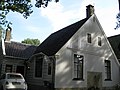 Leeteinde 10.JPG 2,592 × 1,944; 483 KB


