Category:Legeweg 1A, Dokkum
Jump to navigation
Jump to search
| Object location | | View all coordinates using: OpenStreetMap |
|---|
 | |||||
| Upload media | |||||
| Instance of |
| ||||
|---|---|---|---|---|---|
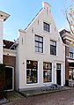
| Location | Dokkum, Noardeast-Fryslân, Friesland, Netherlands | ||||
| Located on street | |||||
| Heritage designation |
| ||||
 | |||||
|
This is a category about rijksmonument number 13147
|
| Address |
|
Media in category "Legeweg 1A, Dokkum"
The following 6 files are in this category, out of 6 total.
-
 Gevels - Dokkum - 20059037 - RCE.jpg 1,200 × 807; 209 KB
-
 Lege weg 1a Dokkum.jpg 1,252 × 1,780; 389 KB
-
 Legeweg 1, Dokkum.JPG 4,032 × 3,024; 2.71 MB
-
 Legeweg 1a, Dokkum.JPG 3,456 × 4,608; 2.97 MB
-
 Overzicht - Dokkum - 20059036 - RCE.jpg 1,200 × 964; 245 KB
-
 Woonhuis Legeweg 1a Dokkum..JPG 3,456 × 4,608; 1.7 MB


