Category:Leysiel
Jump to navigation
Jump to search
| Object location | | View all coordinates using: OpenStreetMap |
|---|
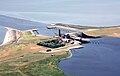
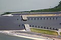
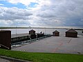
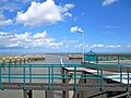
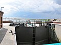
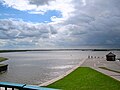
Deutsch: Das Leysiel ist ein kombiniertes Sperrwerk und Siel mit Schleuse nordwestlich von Greetsiel in der Gemeinde Krummhörn (Ostfriesland).
 | |||||
| Upload media | |||||
| Instance of |
| ||||
|---|---|---|---|---|---|
| Location | Krummhörn, Aurich, Lower Saxony, Germany | ||||
| Located in or next to body of water |
| ||||
 | |||||
Media in category "Leysiel"
The following 30 files are in this category, out of 30 total.
-
 Flug Pilsumer Leuchtturm nach Borkum 009.JPG 4,132 × 2,628; 7.46 MB
-
 Flug Pilsumer Leuchtturm nach Borkum 010.JPG 4,272 × 2,848; 8.58 MB
-
 Flug Pilsumer Leuchtturm nach Borkum 017.JPG 4,060 × 2,520; 6.95 MB
-
 Flug Pilsumer Leuchtturm nach Borkum 018.JPG 4,272 × 2,848; 8.09 MB
-
 Flug Pilsumer Leuchtturm nach Borkum 019.JPG 4,272 × 2,848; 8.58 MB
-
 Flug Pilsumer Leuchtturm nach Borkum 020.JPG 4,272 × 2,848; 8.15 MB
-
 Flug Pilsumer Leuchtturm nach Borkum 021.JPG 4,272 × 2,848; 8.33 MB
-
 Flug Pilsumer Leuchtturm nach Borkum 022.JPG 4,272 × 2,848; 7.75 MB
-
 Flug Pilsumer Leuchtturm nach Borkum 023.JPG 4,272 × 2,848; 7.83 MB
-
 Flug Pilsumer Leuchtturm nach Borkum 024.JPG 4,272 × 2,848; 8.32 MB
-
 Flug Pilsumer Leuchtturm nach Borkum 028.JPG 4,272 × 2,848; 7.99 MB
-
 Flug Pilsumer Leuchtturm nach Borkum 029.JPG 4,272 × 2,848; 6.96 MB
-
 Flug Pilsumer Leuchtturm nach Borkum 030.JPG 4,272 × 2,848; 7.23 MB
-
 Flug Pilsumer Leuchtturm nach Borkum 031.JPG 4,152 × 2,688; 6.45 MB
-
 Flug Pilsumer Leuchtturm nach Borkum 032.JPG 4,196 × 2,728; 7.73 MB
-
 Flug Pilsumer Leuchtturm nach Borkum 033.JPG 4,272 × 2,848; 6.26 MB
-
 Flug Pilsumer Leuchtturm nach Borkum 034.JPG 4,272 × 2,848; 6.99 MB
-
 J38 471 Schleuse und Schöpfwerk Leysiel.jpg 5,607 × 3,738; 6.23 MB
-
 Leysiel Deich und Siel.jpg 4,000 × 3,000; 8.26 MB
-
 Leysiel Maschinenhaus.jpg 4,000 × 3,000; 7.32 MB
-
 Leysiel obert.jpeg 4,000 × 6,000; 7.03 MB
-
 Leysiel Schleuse Binnenseite.JPG 4,752 × 3,168; 4.76 MB
-
 Leysiel Schleuse innen Richtung See.JPG 4,752 × 3,168; 4.8 MB
-
 Leysiel Schleuse und Speicherbecken.jpg 4,000 × 3,000; 5.23 MB
-
 Leysiel Schleusenausfahrt.jpg 4,000 × 3,000; 6.21 MB
-
 Leysiel Schleusentor.jpg 4,000 × 3,000; 5.19 MB
-
 Leysiel Sielanlage.jpg 4,000 × 3,000; 6.36 MB
-
 Leysiel Speicherbecken.jpg 4,000 × 3,000; 6.23 MB
-
 Leysiel Sperrwerk mit Schleuse.JPG 4,752 × 3,168; 5.31 MB
-
 Leysiel.jpg 2,373 × 1,582; 1.93 MB


