Category:Linde im Mittelstedter Feld
Jump to navigation
Jump to search
| Object location | | View all coordinates using: OpenStreetMap |
|---|
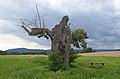
Deutsch: Die Linde im Mittelstedter Feld ist ein Naturdenkmal seit 1938. Sie steht im Feld von Oberursel kurz vor Bad Homburg. Weiteres findet sich hier: Mittelstedten
English: The Linde im Mittelstedter Feld (lime in the field of Mittelstedten) is a protected tree since 1938
Subcategories
This category has only the following subcategory.
Z
- Zeitenwandel am Lindenbäumchen (13 F)
Media in category "Linde im Mittelstedter Feld"
The following 12 files are in this category, out of 12 total.
-
 170326 Oberursel, Linde im Mittelstedter Feld 01.jpg 3,264 × 2,448; 3.3 MB
-
 170326 Oberursel, Linde im Mittelstedter Feld 02.jpg 3,264 × 2,448; 3.48 MB
-
 170326 Oberursel, Linde im Mittelstedter Feld 03.jpg 3,264 × 2,448; 2.88 MB
-
 170326 Oberursel, Linde im Mittelstedter Feld 04.jpg 2,448 × 2,448; 2 MB
-
 170326 Oberursel, Linde im Mittelstedter Feld 05.jpg 3,264 × 2,448; 2.39 MB
-
 170326 Oberursel, Linde im Mittelstedter Feld 06.jpg 3,264 × 2,448; 2.44 MB
-
 170326 Oberursel, Linde im Mittelstedter Feld 07.jpg 3,264 × 2,448; 2.54 MB
-
 170326 Oberursel, Linde im Mittelstedter Feld 08.jpg 2,448 × 3,264; 4.37 MB
-
 180113 Oberursel, Linde im Mittelstedter Feld, Baumschäden 1.jpg 2,448 × 3,264; 2.19 MB
-
 180113 Oberursel, Linde im Mittelstedter Feld, Baumschäden 2.jpg 2,448 × 3,264; 1.23 MB
-
 180113 Oberursel, Linde im Mittelstedter Feld, Baumschäden 3.jpg 2,448 × 3,264; 3.12 MB
-
 Oberursel, Linde im Mittelstedter Feld.jpg 4,928 × 3,264; 5.97 MB


