Category:Long Marston, North Yorkshire
Jump to navigation
Jump to search
village and civil parish in North Yorkshire, UK .JPG) | |||||
| Upload media | |||||
| Instance of | |||||
|---|---|---|---|---|---|
| Location | Harrogate, North Yorkshire, Yorkshire and the Humber, England | ||||
 | |||||
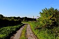
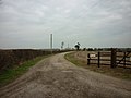
English: Long Marston is a village and civil parish in the Harrogate district of North Yorkshire, England. It is situated on the B1224 road from Wetherby to York, west of York.
Subcategories
This category has the following 9 subcategories, out of 9 total.
Media in category "Long Marston, North Yorkshire"
The following 200 files are in this category, out of 211 total.
(previous page) (next page)-
 412 Connexions Wetherby to York bus (12th June 2013).JPG 3,872 × 2,176; 1.19 MB
-
 A Bend on Seakel Lane - geograph.org.uk - 5026411.jpg 1,600 × 1,067; 582 KB
-
 A corner of Long Marston - geograph.org.uk - 3779303.jpg 1,024 × 768; 193 KB
-
 A plaque for the Battle of Marston Moor - geograph.org.uk - 2306171.jpg 800 × 600; 254 KB
-
 Access Lane to Marston Grange - geograph.org.uk - 5024933.jpg 1,600 × 1,067; 636 KB
-
 All Roads lead to Healaugh - geograph.org.uk - 330356.jpg 640 × 480; 111 KB
-
 Along Wetherby Road - geograph.org.uk - 5611260.jpg 640 × 427; 204 KB
-
 Angram - geograph.org.uk - 3779269.jpg 1,024 × 768; 161 KB
-
 Angram - geograph.org.uk - 5026403.jpg 1,600 × 1,067; 565 KB
-
 Angram Grange - geograph.org.uk - 2728190.jpg 640 × 480; 96 KB
-
 Angram Manor Farm - geograph.org.uk - 2728192.jpg 640 × 480; 78 KB
-
 Angram Road - geograph.org.uk - 4741000.jpg 640 × 480; 49 KB
-

-
 Angram Road, Long Marston (12th June 2013).JPG 3,872 × 2,176; 1.57 MB
-
 Angram Road, Long Marston - geograph.org.uk - 5025812.jpg 1,600 × 1,067; 525 KB
-
 Angram Village - geograph.org.uk - 5611148.jpg 640 × 427; 195 KB
-
 Angram village sign - geograph.org.uk - 4342696.jpg 1,024 × 768; 237 KB
-
 Approaching Fox Covert - geograph.org.uk - 290917.jpg 640 × 427; 71 KB
-
 Arriving at Angram from the east - geograph.org.uk - 5706500.jpg 1,600 × 1,200; 586 KB
-
 Atterwith Lane - geograph.org.uk - 2720831.jpg 640 × 480; 58 KB
-
 Atterwith Lane - geograph.org.uk - 3779317.jpg 1,024 × 768; 177 KB
-
 Atterwith Lane towards Long Marston - geograph.org.uk - 2720844.jpg 640 × 480; 56 KB
-
 Atterwith Lane, Long Marston - geograph.org.uk - 5706461.jpg 1,600 × 1,200; 522 KB
-
 B1224 towards Long Marston - geograph.org.uk - 2726577.jpg 640 × 480; 61 KB
-
 B1224, Long Marston (12th June 2013).JPG 3,872 × 2,176; 2.14 MB
-
 B1244 Wetherby Road near Bilton in Ainsty - geograph.org.uk - 4342748.jpg 1,024 × 768; 139 KB
-
 Barn off Ness Lane - geograph.org.uk - 290945.jpg 640 × 427; 89 KB
-
 Battlefield site, now a muddy field - geograph.org.uk - 6003553.jpg 1,500 × 841; 1.13 MB
-
 Bridge over The Foss, west of Hessay - geograph.org.uk - 5450557.jpg 1,600 × 1,200; 810 KB
-
 Bridleway to Rufforth - geograph.org.uk - 1907345.jpg 2,291 × 2,778; 1.75 MB
-
 Bridleway towards Rufforth - geograph.org.uk - 2728212.jpg 640 × 480; 83 KB
-
 Butt Hedge, Long Marston (12th June 2013).JPG 3,872 × 2,176; 3.38 MB
-
 Caution sign on Wetherby Road (geograph 4342718).jpg 1,024 × 768; 214 KB
-
 Cobit Belt farm track - geograph.org.uk - 4342708.jpg 1,024 × 768; 220 KB
-
 Corner of Tockwith Road and Atterwith Lane - geograph.org.uk - 3779307.jpg 1,024 × 768; 186 KB
-
 Corner on Speng Lane - geograph.org.uk - 5611162.jpg 640 × 427; 185 KB
-
 Country road - geograph.org.uk - 4741023.jpg 640 × 480; 63 KB
-
 Country track - geograph.org.uk - 3779285.jpg 1,024 × 768; 148 KB
-

-
 Dam Bridge - geograph.org.uk - 3779282.jpg 1,024 × 768; 216 KB
-
 Dam Hill towards Hutton Wendesley - geograph.org.uk - 2728204.jpg 640 × 480; 124 KB
-
 Dasysyrphus venustus - hilaris (female) - Flickr - S. Rae (1).jpg 615 × 500; 174 KB
-
 Dasysyrphus venustus - hilaris (female) - Flickr - S. Rae.jpg 701 × 509; 225 KB
-
 Derelict building, Angram Road, Long Marston (12th June 2013).JPG 3,872 × 2,176; 1.69 MB
-
 Edge of the village - geograph.org.uk - 290943.jpg 640 × 427; 64 KB
-
 Encore Direct Plc - geograph.org.uk - 290928.jpg 640 × 427; 103 KB
-
 Entrance to Angram - geograph.org.uk - 4741021.jpg 640 × 480; 52 KB
-
 Entrance to Maran Lakes - geograph.org.uk - 5706476.jpg 1,600 × 1,200; 540 KB
-
 Eumenid wasp sp. - Flickr - S. Rae (1).jpg 824 × 668; 238 KB
-
 Eumenid wasp sp. - Flickr - S. Rae.jpg 678 × 716; 253 KB
-
 Farm building, North End Farm - geograph.org.uk - 2728235.jpg 640 × 480; 52 KB
-
 Farm track along the north side of Cobit Belt - geograph.org.uk - 5268418.jpg 1,024 × 768; 267 KB
-
 Farm track and The Dam - geograph.org.uk - 2728200.jpg 640 × 480; 114 KB
-
 Farm track beside Cobit Belt - geograph.org.uk - 2728208.jpg 640 × 480; 102 KB
-
 Farm track over Marston Field - geograph.org.uk - 2728247.jpg 640 × 480; 69 KB
-
 Farmland between Cobit and Bustard Belts - geograph.org.uk - 5268410.jpg 1,024 × 768; 125 KB
-
 Farmland bordered by Healaugh Lane and the B1224 - geograph.org.uk - 5268446.jpg 1,024 × 768; 126 KB
-
 Farmland near Hutton Wandesley - geograph.org.uk - 2728220.jpg 640 × 480; 97 KB
-
 Farmland off Speng Lane - geograph.org.uk - 5611166.jpg 633 × 640; 332 KB
-
 Farmland off Tockwith Road - geograph.org.uk - 2728243.jpg 640 × 480; 60 KB
-
 Farmland off Wetherby Road - geograph.org.uk - 5611256.jpg 640 × 427; 245 KB
-
 Farmland south of Hutton Wandesley - geograph.org.uk - 2728209.jpg 640 × 480; 68 KB
-
 Farmland towards Round Hill - geograph.org.uk - 2728253.jpg 640 × 480; 96 KB
-
 Farmland, Holly House Farm - geograph.org.uk - 2720842.jpg 640 × 502; 52 KB
-
 Field beside Stubbing Gate - geograph.org.uk - 5548943.jpg 5,184 × 3,456; 6.15 MB
-
 Field boundary near Angram - geograph.org.uk - 5611146.jpg 640 × 427; 248 KB
-
 Field bounded by hedges - geograph.org.uk - 3789743.jpg 1,500 × 1,000; 1.26 MB
-
 Field Edge near Hutton Wandesley - geograph.org.uk - 1907383.jpg 3,200 × 2,400; 2.69 MB
-
 Field entrance off Atterwith Lane - geograph.org.uk - 2720837.jpg 640 × 516; 106 KB
-
 Field in Long Marston - geograph.org.uk - 5025804.jpg 1,600 × 1,067; 553 KB
-
 Field on Wilstrop Moor - geograph.org.uk - 5131313.jpg 1,600 × 1,067; 562 KB
-
 Field with footpath south-west of Long Marston - geograph.org.uk - 2593201.jpg 1,500 × 1,176; 1.7 MB
-
 Field with lone tree at Long Marston - geograph.org.uk - 3824114.jpg 1,500 × 1,125; 1.48 MB
-
 Field with straw bales - geograph.org.uk - 3824120.jpg 1,500 × 1,125; 1.33 MB
-
 Fields north of Angram - geograph.org.uk - 5611160.jpg 640 × 427; 229 KB
-
 Footpath leading to Long Marston - geograph.org.uk - 5547222.jpg 5,184 × 3,456; 7.77 MB
-
 Going through Angram - geograph.org.uk - 5026422.jpg 1,600 × 1,067; 719 KB
-
 Grass Track heading towards Nova Scotia Wood - geograph.org.uk - 5549487.jpg 5,184 × 3,456; 5.55 MB
-
 Harvesting on Marston Moor - geograph.org.uk - 4605247.jpg 640 × 427; 77 KB
-
 Hawthorn at Long Marston 1 April 2023 (1).jpg 3,024 × 4,032; 1.08 MB
-
 Hawthorn at Long Marston 1 April 2023 (2).jpg 3,024 × 4,032; 876 KB
-
 Heading south on Seakel Lane - geograph.org.uk - 3915987.jpg 4,000 × 3,000; 2.82 MB
-
 Healaugh Lane - geograph.org.uk - 5268438.jpg 1,024 × 768; 150 KB
-
 Healaugh Lane - geograph.org.uk - 5547216.jpg 5,184 × 3,456; 7.4 MB
-
 Healaugh Lane - geograph.org.uk - 5611257.jpg 640 × 427; 221 KB
-
 Healaugh Lane heading south - geograph.org.uk - 2728256.jpg 640 × 480; 72 KB
-
 Healaugh Lane near Church Field - geograph.org.uk - 5706466.jpg 1,600 × 1,200; 527 KB
-
 Healaugh Lane near Round Hill - geograph.org.uk - 5706470.jpg 1,600 × 1,200; 633 KB
-
 Hedgerow next to Obelisk - geograph.org.uk - 1343129.jpg 640 × 480; 134 KB
-
 Hillside Farm - geograph.org.uk - 2728249.jpg 640 × 480; 66 KB
-
 Hutton Thorn Woodland - geograph.org.uk - 2726574.jpg 640 × 480; 166 KB
-
 In need of a little TLC - geograph.org.uk - 703748.jpg 640 × 495; 92 KB
-
 Ings Dike from Seakel Lane - geograph.org.uk - 3915991.jpg 4,000 × 3,000; 3.56 MB
-
 Iron Age bracelets positioned roughly as found (FindID 741751).jpg 1,937 × 1,824; 822 KB
-
-
 Keeper's Cottage - geograph.org.uk - 5026031.jpg 1,600 × 1,067; 812 KB
-

-
 Lane to Marston Grange - geograph.org.uk - 290922.jpg 640 × 427; 64 KB
-
 Letterbox in Long Marston - geograph.org.uk - 5611186.jpg 640 × 427; 300 KB
-
 Lonely dust bin on Healaugh Lane - geograph.org.uk - 4342720.jpg 1,024 × 768; 160 KB
-
 Long Marston Post Office - geograph.org.uk - 703742.jpg 640 × 480; 99 KB
-
 Long Marston, North Yorkshire (12th June 2013) 001.JPG 3,872 × 2,176; 2.36 MB
-
 Looking North up Seakel Lane - geograph.org.uk - 5026428.jpg 1,600 × 1,067; 396 KB
-
 Malachius bipustulatus (Common Malachite beetle) - Flickr - S. Rae.jpg 702 × 612; 178 KB
-
 Malachius bipustulatus (Common Malachite Beetle) - Flickr - S. Rae.jpg 860 × 700; 191 KB
-
 Malachius bipustulatus (Malachite Beetle) - Flickr - S. Rae.jpg 1,028 × 874; 371 KB
-
 Marston Animal Supplies, Long Marston (12th June 2013).JPG 3,872 × 2,176; 2.17 MB
-
 Marston Field - geograph.org.uk - 2728246.jpg 640 × 480; 83 KB
-
 Marston Field - geograph.org.uk - 5024945.jpg 1,600 × 1,067; 631 KB
-
 Marston Grange Holiday Cottage - geograph.org.uk - 5706452.jpg 1,600 × 1,200; 558 KB
-
 Marston Moor - geograph.org.uk - 2431855.jpg 3,264 × 2,448; 1.59 MB
-
 Marston Moor - geograph.org.uk - 3779310.jpg 1,024 × 768; 232 KB
-
 Marston Moor Farm - geograph.org.uk - 2720828.jpg 640 × 371; 50 KB
-
 Marston Moor obelisk - geograph.org.uk - 2748648.jpg 2,352 × 2,874; 1.03 MB
-
 Marston Moor Obelisk - geograph.org.uk - 2941690.jpg 480 × 640; 98 KB
-
 Marston Moor Obelisk - geograph.org.uk - 4605243.jpg 640 × 427; 62 KB
-
 Marston Moor Obelisk - geograph.org.uk - 5024965.jpg 1,600 × 1,067; 340 KB
-
 Marston Moor Obelisk - geograph.org.uk - 5706456.jpg 1,600 × 1,200; 370 KB
-
 Melangyna labiatarum (female) - Flickr - S. Rae (15).jpg 724 × 566; 188 KB
-
 Melangyna labiatarum (female) - Flickr - S. Rae (16).jpg 792 × 610; 222 KB
-
 Minor road towards Hutton Wandesley - geograph.org.uk - 2728196.jpg 640 × 480; 76 KB
-
 Moor Drain or Old Cut - geograph.org.uk - 2726584.jpg 640 × 480; 140 KB
-
 Moor Lane (track) - geograph.org.uk - 2728241.jpg 640 × 480; 67 KB
-
 Moor Lane - geograph.org.uk - 3051855.jpg 1,024 × 768; 201 KB
-
 Moor Lane - geograph.org.uk - 5024971.jpg 1,600 × 1,067; 642 KB
-
 Narrow house in Angram - geograph.org.uk - 5611153.jpg 640 × 427; 243 KB
-
 New crop of beans - geograph.org.uk - 4741007.jpg 640 × 480; 147 KB
-
 New crop of beans - geograph.org.uk - 4741014.jpg 640 × 480; 92 KB
-
 New Lane Angram - geograph.org.uk - 4342701.jpg 1,024 × 768; 179 KB
-
 Nomada marshamella (Marsham's Nomad Bee) - Flickr - S. Rae (1).jpg 968 × 768; 319 KB
-
 Nomada marshamella (Marsham's Nomad Bee) - Flickr - S. Rae (2).jpg 1,212 × 892; 612 KB
-
 North End, Long Marston - geograph.org.uk - 290923.jpg 640 × 427; 84 KB
-
 Ochlodes sylvanus (Large Skipper) - Flickr - S. Rae (2).jpg 942 × 804; 340 KB
-
 Ochlodes sylvanus (Large Skipper) - Flickr - S. Rae (3).jpg 842 × 718; 286 KB
-
 Old Lane, Long Marston - geograph.org.uk - 5706482.jpg 1,600 × 1,200; 754 KB
-
 Panorpa communis - Flickr - S. Rae.jpg 1,596 × 1,228; 773 KB
-
 Parasyrphus punctulatus (female) - Flickr - S. Rae (1).jpg 780 × 630; 188 KB
-
 Parasyrphus punctulatus (female) - Flickr - S. Rae.jpg 964 × 864; 296 KB
-
 Parhelophilus sp. - Flickr - S. Rae (3).jpg 830 × 675; 278 KB
-
 Parhelophilus sp. - Flickr - S. Rae (4).jpg 716 × 644; 266 KB
-
 Pipiza sp. (female) - Flickr - S. Rae (2).jpg 906 × 780; 297 KB
-
 Pipiza sp. (female) - Flickr - S. Rae (3).jpg 740 × 642; 170 KB
-
 Pipiza sp. (female) - Flickr - S. Rae (4).jpg 588 × 504; 125 KB
-
 Platycheirus cf. scutatus (male) - Flickr - S. Rae.jpg 1,050 × 831; 305 KB
-
 Ploughed field with lone tree - geograph.org.uk - 3824124.jpg 1,500 × 1,125; 1.57 MB
-
 Poplar Farm - geograph.org.uk - 2728233.jpg 640 × 480; 71 KB
-
 Quad City Challenger II AN0417284.jpg 1,028 × 704; 377 KB
-
 Raj Hamsa X'Air 700 AN0458065.jpg 1,028 × 702; 378 KB
-
 Road junction near Angram - geograph.org.uk - 3779244.jpg 1,024 × 768; 187 KB
-
 Road junction near Holly House Farm - geograph.org.uk - 290916.jpg 640 × 427; 79 KB
-
 Road junction, Atterwith Lane with Marston Lane - geograph.org.uk - 3779326.jpg 1,024 × 768; 148 KB
-
 Saddlers Way, Long Marston (12th June 2013).JPG 3,872 × 2,176; 1.39 MB
-
 Seakel Lane near Askham Richard - geograph.org.uk - 4342689.jpg 768 × 1,024; 220 KB
-
 Small lake near Holly House Farm - geograph.org.uk - 5450562.jpg 1,600 × 1,200; 501 KB
-
-
 Spring Lane - geograph.org.uk - 5025827.jpg 1,600 × 1,067; 422 KB
-
 Spring Lane - geograph.org.uk - 5611172.jpg 640 × 427; 242 KB
-
 Stables, Marston Wyes - geograph.org.uk - 2728257.jpg 640 × 480; 75 KB
-
 Steam engines - geograph.org.uk - 2874507.jpg 640 × 480; 98 KB
-
 Swale's Rash - geograph.org.uk - 5130759.jpg 1,600 × 1,067; 549 KB
-
 The lane from Angram to Hutton Wandesley - geograph.org.uk - 5268406.jpg 1,024 × 768; 120 KB
-
 The pumping station at Angram Dam bridge - geograph.org.uk - 4342706.jpg 1,024 × 768; 311 KB
-
 The Sun Inn (white building) Long Marston - geograph.org.uk - 4342716.jpg 1,024 × 768; 100 KB
-
 The Sun Inn - geograph.org.uk - 5611190.jpg 640 × 427; 211 KB
-
 The way to Marston Grange, near Tockwith - geograph.org.uk - 2306182.jpg 800 × 600; 212 KB
-
 The Wyes - geograph.org.uk - 5547209.jpg 5,184 × 3,456; 7.15 MB
-
 Tockwith Road - geograph.org.uk - 4076528.jpg 640 × 427; 67 KB
-
 Tockwith Road heading west - geograph.org.uk - 2728236.jpg 640 × 480; 45 KB
-
 Tockwith Road heading west - geograph.org.uk - 2728245.jpg 640 × 480; 51 KB
-
 Towards Hillside Farm - geograph.org.uk - 5611253.jpg 640 × 427; 246 KB
-
 Track and stream near Dam Bridge, Angram - geograph.org.uk - 5706492.jpg 1,600 × 1,200; 787 KB
-
 Track beside Bustard Belt - geograph.org.uk - 5026020.jpg 1,600 × 1,067; 373 KB
-
 Track beside Corbit Belt - geograph.org.uk - 5706490.jpg 1,600 × 1,200; 631 KB
-
 Track beside Howcar Farm, Angram - geograph.org.uk - 5706497.jpg 1,600 × 1,200; 864 KB
-
 Track Heading away from Healaugh Lane - geograph.org.uk - 5548937.jpg 5,184 × 3,456; 6.59 MB
-
 Track leading to Healaugh Lane - geograph.org.uk - 5548926.jpg 5,184 × 3,456; 5.81 MB
-
 Track to Marston Wyes Trout Farm - geograph.org.uk - 2728270.jpg 640 × 480; 102 KB
-
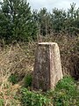 Trig point of Long Marston in shelter belt - geograph.org.uk - 2573502.jpg 1,125 × 1,500; 2.11 MB
-
 Tropidia scita (male) - Flickr - S. Rae (1).jpg 870 × 728; 327 KB
-
 Turn left for Angram - geograph.org.uk - 4342694.jpg 1,024 × 768; 194 KB
-
 Two trees south of Bustard Belt - geograph.org.uk - 5268423.jpg 1,024 × 768; 188 KB
-
 View towards Cromwell Clump - geograph.org.uk - 3051858.jpg 1,024 × 768; 232 KB
-
 View towards Eulic Wood - geograph.org.uk - 5026034.jpg 1,600 × 1,067; 506 KB
-
 View towards Mill Hill and Marston Field - geograph.org.uk - 5547205.jpg 5,184 × 3,456; 7.65 MB
-
 Volucella pellucens (male) - Great Pied Hoverfly - Flickr - S. Rae (1).jpg 1,008 × 909; 318 KB
-

-
 West from next to the Obelisk - geograph.org.uk - 2941695.jpg 640 × 480; 92 KB
-
 Wetherby Road (B1224) heading west - geograph.org.uk - 2728250.jpg 640 × 480; 57 KB
-
 Wide grass verge on the B1224 - geograph.org.uk - 5268464.jpg 1,024 × 768; 162 KB
-
 Woodland near Dam Bridge - geograph.org.uk - 2728201.jpg 640 × 480; 165 KB
-
 Yellow bicycle in Angram - geograph.org.uk - 4076526.jpg 640 × 427; 84 KB
-
 York House - geograph.org.uk - 5611259.jpg 640 × 427; 243 KB
-
 York Road (B1224) heading east - geograph.org.uk - 2728230.jpg 640 × 480; 67 KB
-
 Angram Dam Bridge - geograph.org.uk - 249141.jpg 479 × 640; 164 KB
-
 Atterwith Lane - geograph.org.uk - 177443.jpg 640 × 480; 84 KB
-
 Atterwith Lane - geograph.org.uk - 184520.jpg 640 × 479; 56 KB
-
 Barley - geograph.org.uk - 184522.jpg 640 × 479; 50 KB
-
 Bustard Belt - geograph.org.uk - 249139.jpg 640 × 479; 83 KB
-
 Corbit Belt - geograph.org.uk - 178827.jpg 600 × 450; 101 KB
-
 Cows - Long Marston - geograph.org.uk - 184526.jpg 640 × 479; 51 KB
.JPG)


.JPG)


.JPG)


.JPG)
.jpg)


_-_Flickr_-_S._Rae_(1).jpg)
_-_Flickr_-_S._Rae.jpg)
.JPG)


.jpg)


.jpg)
.jpg)


.jpg)
_-_geograph.org.uk_-_5268454.jpg)


_001.JPG)

_-_Flickr_-_S._Rae.jpg)
_-_Flickr_-_S._Rae.jpg)
_-_Flickr_-_S._Rae.jpg)
.JPG)


_-_Flickr_-_S._Rae_(15).jpg)
_-_Flickr_-_S._Rae_(16).jpg)


_-_geograph.org.uk_-_2728241.jpg)


_-_Flickr_-_S._Rae_(1).jpg)
_-_Flickr_-_S._Rae_(2).jpg)

_-_Flickr_-_S._Rae_(2).jpg)
_-_Flickr_-_S._Rae_(3).jpg)


_-_Flickr_-_S._Rae_(1).jpg)
_-_Flickr_-_S._Rae.jpg)
.jpg)
.jpg)
_-_Flickr_-_S._Rae_(2).jpg)
_-_Flickr_-_S._Rae_(3).jpg)
_-_Flickr_-_S._Rae_(4).jpg)
_-_Flickr_-_S._Rae.jpg)


.JPG)


_Long_Marston_-_geograph.org.uk_-_4342716.jpg)


_-_Flickr_-_S._Rae_(1).jpg)


_-_Great_Pied_Hoverfly_-_Flickr_-_S._Rae_(1).jpg)
_-_Great_Pied_Hoverfly_-_Flickr_-_S._Rae_(2).jpg)

_heading_west_-_geograph.org.uk_-_2728250.jpg)


_heading_east_-_geograph.org.uk_-_2728230.jpg)


