<nowiki>Märkische Höhe; Märkische Höhe; Märkische Höhe; Märkische Höhe; Märkische Höhe; Märkische Höhe; Меркише-Хоьэ; مرکیشه هوهه; 梅尔基舍赫黑; Märkische Höhe; Märkische Höhe; 梅爾基舍赫黑; Märkische Höhe; Меркіше-Гее; Меркише-Хёэ; 梅爾基舍赫黑; Märkische Höhe; Märkische Höhe; Меркише Хее; Märkische Höhe; Märkische Höhe; Märkische Höhe; Märkische Höhe; Меркише Хее; Märkische Höhe; Märkische Höhe; Меркише Хее; Märkische Höhe; Märkische Höhe; Märkische Höhe; Märkische Höhe; Märkische Höhe; Merkiše Hee; Меркише-Хёэ; Märkische Höhe; メルキッシェ・ヘーエ; Märkische Höhe; Märkische Höhe; 梅尔基舍赫黑; Մերկիշ Հոհե; comune tedesco; commune allemande; municipality of Germany; Gemeinde in Deutschland; komunë në Gjermani; 德国勃兰登堡州市镇; Şaredariyeke Almanyayê; kumun alaman; kommune i Tyskland; gemeente in Brandenburg; громада в Німеччині, федеральна земля Бранденбург; municipio de Alemania; بلدية في ألمانيا; település Németországban; municipality of Germany; komunumo en Brandenburgio, Germanio; obec v zemském okresu Märkisch-Oderland v Německu; gmejna w Braniborskej; Markische Hohe; Märkische Höhe; Мäркисче Ҳöҳе; Merkishe-Xyoe; Меркише-Хёэ; Markische Hohe; Merkishe Xyoe; Maerkische Hoehe; Markische Hohe; Maerkische Hoehe; Меркише-Хеэ; Markische Hohe; Maerkische Hoehe</nowiki>
Subcategories
This category has the following 7 subcategories, out of 7 total.


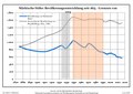 Bevölkerungsentwicklung Märkische Höhe.pdf 1,752 × 1,239; 119 KB
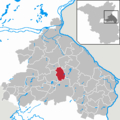 Märkische Höhe in MOL.png 299 × 299; 6 KB