Category:Maarland Noordzijde 17, Brielle
Jump to navigation
Jump to search
| Object location | | View all coordinates using: OpenStreetMap |
|---|
 | |||||
| Upload media | |||||
| Instance of |
| ||||
|---|---|---|---|---|---|
| Location | Brielle, Voorne aan Zee, South Holland, Netherlands | ||||
| Street address |
| ||||
| Located on street | |||||
| Heritage designation |
| ||||
 | |||||
|
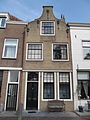
This is a category about rijksmonument number 10712
|
| Address |
|
Media in category "Maarland Noordzijde 17, Brielle"
The following 6 files are in this category, out of 6 total.
-
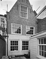 Achterzijde - Brielle - 20042978 - RCE.jpg 951 × 1,200; 243 KB
-
 Overzicht - Brielle - 20042968 - RCE.jpg 1,200 × 959; 232 KB
-
 Overzicht - Brielle - 20042998 - RCE.jpg 1,200 × 804; 195 KB
-
 RM10712 Brielle - Maarland Noordzijde 17.jpg 1,944 × 2,592; 1.4 MB
-
 Voorgevel - Brielle - 20042979 - RCE.jpg 959 × 1,200; 217 KB
-
 Voorgevels - Brielle - 20042977 - RCE.jpg 1,200 × 959; 223 KB


