Category:Maarland Noordzijde 40, Brielle
Jump to navigation
Jump to search
| Object location | | View all coordinates using: OpenStreetMap |
|---|
 | |||||
| Upload media | |||||
| Instance of |
| ||||
|---|---|---|---|---|---|
| Location | Brielle, Voorne aan Zee, South Holland, Netherlands | ||||
| Street address |
| ||||
| Located on street | |||||
| Heritage designation |
| ||||
 | |||||
|
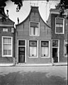
This is a category about rijksmonument number 10725
|
| Address |
|
Media in category "Maarland Noordzijde 40, Brielle"
The following 4 files are in this category, out of 4 total.
-
 Exterieur STEEN BOVEN VOORDEUR - Brielle - 20316299 - RCE.jpg 1,200 × 788; 317 KB
-
 Overzicht - Brielle - 20043017 - RCE.jpg 1,200 × 804; 208 KB
-
 RM10725 Brielle - Maarland Noordzijde 40.jpg 1,944 × 2,592; 1.29 MB
-
 Voorgevel - Brielle - 20043009 - RCE.jpg 959 × 1,200; 221 KB


