Category:Maarland Noordzijde 68, Brielle
Jump to navigation
Jump to search
| Object location | | View all coordinates using: OpenStreetMap |
|---|
 | |||||
| Upload media | |||||
| Instance of |
| ||||
|---|---|---|---|---|---|
| Location | Brielle, Voorne aan Zee, South Holland, Netherlands | ||||
| Street address |
| ||||
| Located on street | |||||
| Heritage designation |
| ||||
 | |||||
|
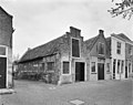
This is a category about rijksmonument number 10739
|
| Address |
|
Media in category "Maarland Noordzijde 68, Brielle"
The following 6 files are in this category, out of 6 total.
-
 Brielle - panoramio (1).jpg 4,928 × 3,264; 12.56 MB
-
 Brielle - panoramio (2).jpg 3,264 × 4,928; 12.29 MB
-
 Brielle - panoramio (4).jpg 4,928 × 3,264; 14.8 MB
-
 RM10739 Brielle - Maarland Noordzijde 68.jpg 1,944 × 2,592; 1.15 MB
-
 Voorgevels - Brielle - 20043022 - RCE.jpg 1,200 × 946; 228 KB
-
 Voorgevels - Brielle - 20043023 - RCE.jpg 1,200 × 944; 232 KB
.jpg)
.jpg)
.jpg)

