Category:Mackworth, Amber Valley
Jump to navigation
Jump to search
village and civil parish in Amber Valley district, Derbyshire, England  | |||||
| Upload media | |||||
| Instance of | |||||
|---|---|---|---|---|---|
| Location | Amber Valley, Derbyshire, East Midlands, England | ||||
| Different from | |||||
 | |||||
Subcategories
This category has the following 2 subcategories, out of 2 total.
A
- All Saints, Mackworth (15 F)
M
- Mackworth Castle (4 F)
Media in category "Mackworth, Amber Valley"
The following 149 files are in this category, out of 149 total.
-
 A view towards Derby from Meynell Langley - geograph.org.uk - 5366156.jpg 2,000 × 1,333; 1.59 MB
-
 A52 at Mackworth - geograph.org.uk - 4602090.jpg 1,280 × 960; 351 KB
-
 A52 towards Mackworth - geograph.org.uk - 3882930.jpg 3,088 × 2,056; 2.35 MB
-
 All Saints Church, Mackworth Village - geograph.org.uk - 4580195.jpg 640 × 480; 51 KB
-
 All Saints, Mackworth with Markeaton - geograph.org.uk - 4601775.jpg 1,280 × 960; 309 KB
-
 All Saints, Mackworth with Markeaton - geograph.org.uk - 4601785.jpg 1,280 × 922; 337 KB
-

-
 Ashbourne Road (A52) - geograph.org.uk - 4580171.jpg 640 × 480; 68 KB
-
 Ashbourne Road (A52) - geograph.org.uk - 4580174.jpg 640 × 480; 71 KB
-
 Ashbourne Road (A52) - geograph.org.uk - 4580180.jpg 640 × 374; 67 KB
-
 Ashbourne Road (A52) - geograph.org.uk - 4580189.jpg 640 × 480; 52 KB
-
 Ashbourne Road (A52), Mackworth - geograph.org.uk - 4580183.jpg 640 × 480; 68 KB
-
 Ashbourne Road - geograph.org.uk - 1837320.jpg 640 × 480; 59 KB
-
 Ashbourne Road at Mackworth - geograph.org.uk - 1837324.jpg 640 × 480; 51 KB
-
 Ashbourne Road at Mackworth - geograph.org.uk - 1837326.jpg 640 × 480; 79 KB
-
 Ashbourne Road at Mackworth - geograph.org.uk - 1837328.jpg 640 × 480; 64 KB
-
 Autumn colour - geograph.org.uk - 5350532.jpg 2,832 × 2,128; 4.82 MB
-
 Autumnal colour - geograph.org.uk - 5350533.jpg 1,503 × 2,000; 3.27 MB
-
 Boggy field - geograph.org.uk - 6240716.jpg 1,280 × 960; 476 KB
-
 Bowbridge Fields Farm - geograph.org.uk - 2251228.jpg 3,648 × 2,736; 5.49 MB
-

-
 Bowbridge Services - geograph.org.uk - 3172178.jpg 1,024 × 768; 210 KB
-

-
 Bridleway Bordering Kedleston Park - geograph.org.uk - 3581371.jpg 4,000 × 3,000; 2.66 MB
-
 Bridleway near Markeaton Stones Farm - geograph.org.uk - 3581342.jpg 4,000 × 3,000; 2.48 MB
-
 Bridleway to the West of Allestree - geograph.org.uk - 3581345.jpg 4,000 × 3,000; 2.67 MB
-
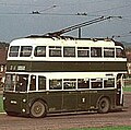 British Trolleybuses - Derby DYK.jpg 194 × 193; 17 KB
-
 Brun Lane - geograph.org.uk - 4580181.jpg 640 × 480; 81 KB
-
 Brun Lane - geograph.org.uk - 4602097.jpg 1,280 × 960; 442 KB
-
 Brun Lane near Bowbridge Woods - geograph.org.uk - 5046744.jpg 4,000 × 3,000; 3.43 MB
-
 Brun Lane near Derby - geograph.org.uk - 5386617.jpg 2,000 × 1,333; 2.71 MB
-
 Bus stop on Ashbourne Road (A52) - geograph.org.uk - 4580187.jpg 640 × 480; 63 KB
-
 Castle Gate - geograph.org.uk - 5341056.jpg 1,333 × 2,000; 3.2 MB
-
 Cereal crop near Mackworth - geograph.org.uk - 4602030.jpg 1,280 × 960; 328 KB
-
 Churchyard gateway, Mackworth - geograph.org.uk - 4601788.jpg 960 × 1,280; 324 KB
-
 Cottages on Lower Road - geograph.org.uk - 4601795.jpg 1,280 × 960; 301 KB
-
 Croydon Walk, Mackworth - geograph.org.uk - 6236601.jpg 1,024 × 768; 129 KB
-
 Cutting the corner - geograph.org.uk - 6240709.jpg 1,280 × 960; 519 KB
-
 Derby Van Sales - geograph.org.uk - 4602101.jpg 1,280 × 960; 259 KB
-
 Derbyshire UK parish map highlighting Mackworth.svg 888 × 1,308; 2.34 MB
-
 East end of Ladbroke Gardens, Mackworth - geograph.org.uk - 6236609.jpg 1,024 × 768; 114 KB
-
 Eat, clean and fill up - geograph.org.uk - 2251237.jpg 3,648 × 2,736; 5.26 MB
-
 Edgware Road, Mackworth - geograph.org.uk - 6236613.jpg 1,024 × 768; 168 KB
-
 Farm buildings at Home Farm, Mackworth - geograph.org.uk - 4602078.jpg 1,280 × 813; 330 KB
-
 Farmyard at Mackworth House Farm - geograph.org.uk - 4602054.jpg 1,280 × 908; 327 KB
-
 Field below Mackworth village - geograph.org.uk - 4601828.jpg 1,280 × 869; 256 KB
-

-
 Field of wheat under an ominous sky - geograph.org.uk - 6242134.jpg 1,280 × 960; 370 KB
-
 Fields at Mackworth - geograph.org.uk - 2251288.jpg 3,648 × 2,736; 4.7 MB
-
 Fields by Meynell Langley - geograph.org.uk - 2250467.jpg 3,648 × 2,736; 5.55 MB
-

-
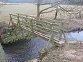
 Footbridge over the Mackworth Brook - geograph.org.uk - 4602026.jpg 1,280 × 824; 535 KB
-
 Footpath and Fields near Lower Vicarwood - geograph.org.uk - 4273382.jpg 4,000 × 3,000; 2.47 MB
-
 Footpath near Bowbridge Fields Cottage - geograph.org.uk - 6401590.jpg 4,032 × 3,024; 3.2 MB
-
 Footpath to Quarndon - geograph.org.uk - 6240720.jpg 1,280 × 960; 524 KB
-
 Footpath towards Lower Vicarwood - geograph.org.uk - 4602029.jpg 1,280 × 871; 292 KB
-
 Footpath with kissing gate - geograph.org.uk - 4601780.jpg 1,280 × 960; 460 KB
-
 Former filling station at Mackworth - geograph.org.uk - 4602096.jpg 1,280 × 927; 317 KB
-
 Free Range - geograph.org.uk - 2250462.jpg 1,600 × 1,136; 692 KB
-
 From Vicar Wood towards Kedleston Hall - geograph.org.uk - 4211566.jpg 3,986 × 2,222; 4.56 MB
-
 Garage on the Ashbourne Road - geograph.org.uk - 1837332.jpg 640 × 480; 53 KB
-
 Gate into a field, Markeaton Lane - geograph.org.uk - 2263205.jpg 3,648 × 2,736; 5.14 MB
-
 Gold Lane - geograph.org.uk - 4602127.jpg 1,280 × 960; 597 KB
-
 Gold Lane, Mackworth - geograph.org.uk - 2251277.jpg 3,648 × 2,736; 4.59 MB
-
 Grazing near Mackworth - geograph.org.uk - 4580178.jpg 640 × 480; 63 KB
-
 Grazing off Ashbourne Road (A52) - geograph.org.uk - 4580173.jpg 640 × 480; 68 KB
-
 Grazing, Mackworth - geograph.org.uk - 4580185.jpg 640 × 480; 78 KB
-
 Home Farm farmyard - geograph.org.uk - 4602088.jpg 1,280 × 940; 309 KB
-
 Home Farm, Mackworth - geograph.org.uk - 4535213.jpg 640 × 480; 83 KB
-
 Home Farm, with Araucaria araucana - geograph.org.uk - 2251259.jpg 3,648 × 2,736; 5.06 MB
-
 Home Farmhouse, Mackworth.jpg 1,280 × 961; 432 KB
-
 Horses grazing in a ridge and furrow field - geograph.org.uk - 6242138.jpg 1,280 × 960; 412 KB
-
 Houses for sale - geograph.org.uk - 6108565.jpg 2,000 × 1,333; 1.91 MB
-
 Houses off Westbourne Park, Mackworth - geograph.org.uk - 6236595.jpg 1,024 × 768; 105 KB
-
 Ivy Cottage, Mackworth - geograph.org.uk - 4602042.jpg 1,280 × 889; 338 KB
-
 Jarvey's Lane - geograph.org.uk - 5341054.jpg 2,000 × 1,336; 1.71 MB
-
 Jarvey's Lane. Mackworth - geograph.org.uk - 4602094.jpg 1,280 × 960; 479 KB
-
 Kedleston Hall and Park - geograph.org.uk - 3182220.jpg 3,264 × 2,448; 3.12 MB
-
 Kedleston Hall, aerial 2014 - geograph.org.uk - 3926242.jpg 1,024 × 683; 122 KB
-
 Lane passing Markeaton Stones - geograph.org.uk - 6297944.jpg 1,024 × 768; 258 KB
-
 Langley Country Park Phase 2 - geograph.org.uk - 5621557.jpg 1,280 × 960; 305 KB
-
 Looking across fields - geograph.org.uk - 5403076.jpg 2,000 × 1,333; 3.01 MB
-
 Low rise flats on Finchley Avenue, Mackworth - geograph.org.uk - 6236617.jpg 1,024 × 768; 117 KB
-
 Lower House Farm, Mackworth - geograph.org.uk - 4602050.jpg 1,280 × 865; 281 KB
-
 Lower Lane, Mackworth - geograph.org.uk - 4601776.jpg 1,280 × 960; 374 KB
-
 Lower Road in Mackworth - geograph.org.uk - 3502257.jpg 4,000 × 3,000; 2.8 MB
-
 Lower Vicarwood - geograph.org.uk - 4273390.jpg 4,000 × 3,000; 2.15 MB
-
 Lower Vicarwood Farm - geograph.org.uk - 1808405.jpg 1,728 × 1,152; 177 KB
-
 Lower Vicarwood Farm - geograph.org.uk - 291103.jpg 640 × 480; 78 KB
-
 Lower Vicarwood Farm, Mackworth-Kedleston, Derbyshire - geograph.org.uk - 1811135.jpg 1,600 × 1,200; 318 KB
-
 Mackworth Church - geograph.org.uk - 5318600.jpg 4,181 × 3,142; 1.31 MB
-
 Mackworth House Farmhouse - geograph.org.uk - 4602061.jpg 1,280 × 882; 348 KB
-
 Mackworth postbox ref DE 297 - geograph.org.uk - 4602046.jpg 1,280 × 960; 461 KB
-
 Mackworth village - geograph.org.uk - 4602130.jpg 1,280 × 960; 325 KB
-
 Mackworth Village, Derbyshire - geograph.org.uk - 1659923.jpg 640 × 480; 54 KB
-
 Mackworth Water Tower - geograph.org.uk - 77562.jpg 640 × 480; 15 KB
-
 Mackworth, All Saints - geograph.org.uk - 6360746.jpg 4,000 × 3,000; 4.68 MB
-

-

-
 Markeaton Stones - geograph.org.uk - 2263217.jpg 3,648 × 2,736; 5.25 MB
-
 Markeaton Stones, Markeaton, Derbyshire - geograph.org.uk - 1807062.jpg 1,200 × 1,600; 341 KB
-
 Mundy Arms, Mackworth - geograph.org.uk - 4602104.jpg 1,280 × 1,280; 475 KB
-
 Mundy Arms, Mackworth - geograph.org.uk - 4602108.jpg 1,280 × 960; 268 KB
-
 Mundy Arms, Mackworth - geograph.org.uk - 4602123.jpg 1,280 × 960; 315 KB
-
 Mundy Tomb, Mackworth - geograph.org.uk - 4601790.jpg 960 × 1,280; 390 KB
-
 Near Home Farm - geograph.org.uk - 5519674.jpg 2,000 × 1,333; 2.47 MB
-
 New houses on the edge of Derby - geograph.org.uk - 6108564.jpg 2,000 × 1,333; 1.94 MB
-
 Old School House - geograph.org.uk - 81016.jpg 640 × 387; 93 KB
-
 On a farm access lane - geograph.org.uk - 2250448.jpg 3,648 × 2,736; 5 MB
-
 On the Bonnie Prince Charlie Walk - geograph.org.uk - 2251298.jpg 3,648 × 2,736; 5.57 MB
-
 Paddock north of Markeaton Stones - geograph.org.uk - 6297941.jpg 1,024 × 768; 180 KB
-
 Path through the trees at Kedleston Hall - geograph.org.uk - 2653459.jpg 683 × 1,024; 316 KB
-
 Pillbox in a field - geograph.org.uk - 6240727.jpg 1,280 × 960; 512 KB
-
 Pond with willows near Mackworth - geograph.org.uk - 6019629.jpg 1,280 × 960; 544 KB
-
 Prospect of Derby - geograph.org.uk - 2250452.jpg 3,648 × 2,736; 4.74 MB
-

-
-
 Public Footpath, Derbyshire - geograph.org.uk - 1818357.jpg 1,200 × 1,600; 514 KB
-
 Public Footpath, Derbyshire - geograph.org.uk - 1818362.jpg 1,600 × 1,200; 444 KB
-
 Rape stubble near Mackworth - geograph.org.uk - 4601777.jpg 1,280 × 910; 323 KB
-
 Recreation ground in Langley Country Park - geograph.org.uk - 5621583.jpg 1,280 × 960; 370 KB
-
 Reinforcing Skitteridge's Wood - geograph.org.uk - 6019621.jpg 1,280 × 960; 651 KB
-
 Ridge and furrow field at Mackworth - geograph.org.uk - 6019626.jpg 1,280 × 960; 529 KB
-
 Road junction, A52 - geograph.org.uk - 2251252.jpg 3,648 × 2,736; 5.88 MB
-

-

-

-
 Showroom and Housing Development in Mackworth - geograph.org.uk - 4285635.jpg 4,000 × 3,000; 1.85 MB
-
 Skitteridge Wood - geograph.org.uk - 356929.jpg 640 × 480; 130 KB
-
 Specimen oak tree - geograph.org.uk - 6240713.jpg 1,280 × 960; 532 KB
-
 Start of a path to Meynell Langley - geograph.org.uk - 6237252.jpg 1,280 × 960; 757 KB
-
 Summer Countryside viewed from Brun Lane - geograph.org.uk - 3501907.jpg 4,000 × 3,000; 2.96 MB
-
 Sunrise - Summer Solstice 2010 - geograph.org.uk - 1932217.jpg 3,008 × 2,000; 2.45 MB
-
 The Back Grounds at Kedleston Hall - geograph.org.uk - 2653456.jpg 1,024 × 683; 154 KB
-
 The bridle way to Vicarwood - geograph.org.uk - 5403103.jpg 2,000 × 1,333; 2.59 MB
-
 The Thatched Cottage, Mackworth.jpg 1,280 × 839; 280 KB
-
 The view from the A52 - geograph.org.uk - 5403080.jpg 2,000 × 1,333; 2.84 MB
-
 Track north of Markeaton Stones - geograph.org.uk - 6297938.jpg 1,024 × 768; 247 KB
-
 Upper Vicarwood - geograph.org.uk - 2250458.jpg 3,648 × 2,736; 5.38 MB
-
 Upper Vicarwood - geograph.org.uk - 3581349.jpg 3,866 × 2,812; 2.43 MB
-
 Upper Vicarwood Farm near Quarndon, Derbyshire - geograph.org.uk - 1807083.jpg 1,600 × 1,200; 359 KB
-
 View through the gatehouse - geograph.org.uk - 4602072.jpg 936 × 1,280; 342 KB
-
 Water Tower at Mackworth - geograph.org.uk - 2263227.jpg 3,648 × 2,736; 5.55 MB
-
 Water Tower, Mackworth - geograph.org.uk - 6248373.jpg 5,472 × 3,648; 3.85 MB
-
 Weir and splash pool in Kedleston Park - geograph.org.uk - 4211562.jpg 3,974 × 2,200; 6.71 MB
-
 Westbourne Park, Mackworth - geograph.org.uk - 6236596.jpg 1,024 × 768; 100 KB
-

-

-
 A52 at Mackworth - geograph.org.uk - 291110.jpg 640 × 480; 49 KB


_-_geograph.org.uk_-_4580171.jpg)
_-_geograph.org.uk_-_4580174.jpg)
_-_geograph.org.uk_-_4580180.jpg)
_-_geograph.org.uk_-_4580189.jpg)
,_Mackworth_-_geograph.org.uk_-_4580183.jpg)


_-_geograph.org.uk_-_4580187.jpg)


_-_geograph.org.uk_-_4535220.jpg)


_-_geograph.org.uk_-_4580173.jpg)


_-_geograph.org.uk_-_4535202.jpg)


,_aerial_2014_-_geograph.org.uk_-_3926035.jpg)
,_aerial_2014_-_geograph.org.uk_-_3926037.jpg)
