Category:Macquarie Island
Sari la navigare
Sari la căutare
|
Acest loc face parte din Patrimoniul Mondial al UNESCO, listed as
Macquarie Island.
|
English: Macquarie Island is a Sub-Antarctic island that is located at 54°37′S 158°51′E. Macquarie Island is the southern-most part of Australia.
sub-Antarctic island of Australia  Остров Маккуори | |||||
| Încarcă multimedia | |||||
| Este un/o | |||||
|---|---|---|---|---|---|
| Numit(ă) după | |||||
| Locul actual |
| ||||
| Localizat pe malul | |||||
| Descoperit(ă) de |
| ||||
| Statut al patrimoniului |
| ||||
| Data descoperirii sau inventării |
| ||||
| Lățime |
| ||||
| Lungime |
| ||||
| Cel mai înalt punct |
| ||||
| Populație |
| ||||
| Suprafață |
| ||||
| Altitudine deasupra nivelului mării |
| ||||
| Diferit(ă) de | |||||
 | |||||
Subcategorii
Această categorie conține următoarele 4 subcategorii, dintr-un total de 4.
Fișiere media din categoria „Macquarie Island”
Următoarele 32 fișiere se află în această categorie, dintr-un total de 32.
-
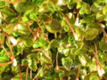
 Acaena minor Stevage.jpg 2.124x1.355; 607 KB
-

-
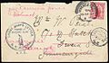 Antarctic Mail 1911.jpg 1.100x644; 239 KB
-
AudioElleSeals.oga 8,1 s; 70 KB
-
AudioRoyalPenguins.oga 18 s; 185 KB
-
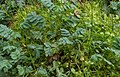
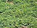
 Azorella macquariensis.jpg 900x671; 691 KB
-
 Eudyptes schlegeli distribution (nesting).png 592x470; 42 KB
-

-
 Galium antarcticum.jpg 1.000x749; 381 KB
-
King Penguin Rookery Audio.oga 29 s; 291 KB
-
 M 5.9 - West of Macquarie Island, 20170309.png 1.302x948; 2,04 MB
-
 Macquarie - Landsat OLI 79.png 2.500x2.500; 1,41 MB
-
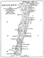 Macquarie Island Map Mawson.png 620x821; 468 KB
-
 Macquarie Island STS092.JPG 1.181x886; 172 KB
-

-
 Macquarie Island, Australia (ASTER).jpg 718x2.376; 155 KB
-
Macquarie Island, Australia (Part 2).webm 1 min 5 s, 3.840 × 2.160; 99,96 MB
-
 Macquarie station, Macquarie Island.JPG 4.608x3.456; 2,89 MB
-
 Macquarieisland oli2 2022039 lrg.jpg 1.957x1.305; 367 KB
-
 MacquarieIsland2.JPG 3.072x2.304; 1,54 MB
-
 MacquarieIsland3.JPG 3.072x2.304; 1,38 MB
-
 MacquarieIsland4.JPG 3.072x2.304; 1,63 MB
-
 MacquarieIsland5.JPG 3.072x2.304; 3,2 MB
-
 MacquarieIsland6.JPG 3.072x2.304; 2,38 MB
-
 Orthographic projection over Macquarie Island.png 488x487; 21 KB
-
 Plerophyllum-hookeri-in-flower-Mac-Hamilton.png 772x602; 816 KB
-
 Pleurophyllum hookeri Macquarie Island.jpg 1.224x816; 1 MB
-
 QSL VK0KH (1980).jpg 1.090x707; 76 KB
-
 Ship-wave-shaped wave clouds induced by Macquarie Island (MODIS 2018-03-05).jpg 2.600x2.000; 851 KB
-
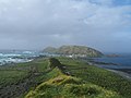
 Wild west coast of Macquarie Island.jpg 1.024x782; 189 KB
-
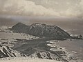
 Wireless Hill from the south.JPG 590x442; 51 KB
-
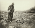
 Wireless Hill, Macquarie Island, Australia - 1911-1914.jpg 4.485x3.349; 1,8 MB


.png)
.jpg)


.jpg)


.jpg)
.jpg)


.jpg)